


OCEANSIDE, NETARTS WEATHER | SKY CAMS | TIDES | WAVE FORECASTS | ALERTS | OREGON COAST
Updated Constantly: Oceanside Oregon to Tillamook Oregon Coast Weather | Cams | Tides | Alerts - Current conditions, forecasts, tides, weather, live radar weather cams, North Coast Range travel, storm alerts | Buoy reports and reports from passing ships | Live Radar
OCEANSIDE - NETARTS OREGON 7-DAY FORECAST
7-Day Forecast
Detailed Forecast
NETARTS WEATHER
7-Day Forecast
Detailed Forecast
OCEANSIDE + NETARTS WAVES FORECAST
Wave Forecast
Small Craft Advisory issued June 19 at 1:11AM PDT until June 19 at 5:00AM PDT by NWS Portland OR
19 Jun 2026 at 2:11am
* WHAT...Seas 6 to 9 ft at 9 seconds and north winds 5 to 15 kt.
* WHERE...Inner Coastal Waters from Cape Shoalwater to Florence
out 10 NM.
* WHEN...Until 5 AM PDT early this morning.
* IMPACTS...Conditions will be hazardous to small craft.
Small Craft Advisory issued June 18 at 1:16PM PDT until June 19 at 5:00AM PDT by NWS Portland OR
18 Jun 2026 at 2:16pm
* WHAT...Seas 6 to 9 ft at 9 seconds and north winds 10 to 20 kt
with gusts up to 25 kt.
* WHERE...Inner Coastal Waters from Cape Shoalwater to Florence
out 10 NM.
* WHEN...Until 5 AM PDT Friday.
* IMPACTS...Conditions will be hazardous to small craft.
Small Craft Advisory issued June 18 at 9:58AM PDT until June 19 at 5:00AM PDT by NWS Portland OR
18 Jun 2026 at 10:58am
* WHAT...Seas 6 to 9 ft at 9 seconds and north winds 10 to 20 kt
with gusts up to 25 kt.
* WHERE...Inner Coastal Waters from Cape Shoalwater to Florence
out 10 NM.
* WHEN...Until 5 AM PDT Friday.
* IMPACTS...Conditions will be hazardous to small craft.
![]()
NDBC - Station 46089 - TILLAMOOK, OR - 85 NM WNW of Tillamook, OR Observations
This feed shows recent marine weather observations from Station 46089.
Station 46089 - TILLAMOOK, OR - 85 NM WNW of Tillamook, OR
22 Jun 2026 at 10:40pm
June 22, 2026 9:10 pm PDT
Location: 45.928N 125.815W
Wind Direction: NNW (340°)
Wind Speed: 15.6 knots
Wind Gust: 17.5 knots
Average Period: 5.3 sec
Mean Wave Direction: NNW (328°)
Atmospheric Pressure: 30.06 in (1017.8 mb)
Water Temperature: 59.7°F (15.4°C)
Oregon Coast Highway, Coast Range Passes Traffic, Road Conditions - | - Portland, Oregon Highway Traffic, Road Conditions - Traffic Cams: I-5 - I-205 - I-405 - Hwy 217 - I-84 - | - List of Oregon Coast Webcams - Weather Cams
NORTH OREGON COAST RANGE - if empty then no alerts


OCEANSIDE WEB CAMS

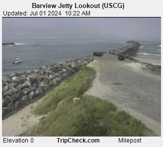
Oceanside-Area Web Cam (nearby at Barview click here to explore)

N. Oregon Coast Live Weather Radar
Oceanside Area Buoy Live Cam - West of the Bay
Oceanside and Three Capes, Oregon Coast Lodging, Hotels, Motels, Restaurants, Inns, Vacation Rentals
Pacific City, Oceanside, Netarts, Oregon, Neskowin, Three Capes Loop Lodging,...
Find places to stay in Pacific City, Oceanside, Netarts, Neskowin Oregon, Three Capes Loop; places to eat, dine in Pacific City, Oceanside
Kiwanda Coastal Properties
Large variety of vacation rentals around Pacific City
Idyllic Beach Houses
Two lovely pet friendly vacation rental homes, close to beach; Tierra Del Mar
Ocean Front Cabins, Oceanside
Historic inn with loads of charm
Sheltered Nook at Tillamook Bay
Vacation rentals at Bay City, tiny homes, very eco-friendly
Vacation Rentals in Pacific City
Includes rentals not listed anywhere else
Oceanfront Cottages, Rentals at Oceanside
Rental cottages above ocean, soaking tub, large deck
Lodging, Rentals in Neskowin
Vacation rentals and lodging in Neskowin, as well as Pacific City, Oceanside
Dining, Restaurants, Menus in Pacific City, Oceanside, Netarts, Tillamook Bay
Latest Three Capes Lodging News, Oceanside, Netarts, Tierra Del Mar, P City
Specials, updates from places to stay along the Three Capes Route, North Oregon coast, Travel tips

BUOY REPORTS - SHIP OBSERVATIONS
![]()
NDBC - Station Observations near 45.93N 125.82W
This feed shows recent marine weather observations from NDBC and its partners within 100 nautical miles of 45.93N 125.82W.
Station 46029 - COLUMBIA RIVER BAR - 20NM WEST OF COLUMBIA RIVER MOUTH
22 Jun 2026 at 10:48pm
June 22, 2026 8:20 pm PST
Location: 46.148N 124.508W or 56 nautical miles ENE of search location of 45.93N 125.82W.
Wind Direction: NNW (340°)
Wind Speed: 14 knots
Wind Gust: 17 knots
Significant Wave Height: 5 ft
Dominant Wave Period: 8 sec
Average Period: 5.2 sec
Mean Wave Direction: NW (322°)
Atmospheric Pressure: 30.02 in (1016.5 mb)
Air Temperature: 55°F (12.7°C)
Water Temperature: 57°F (14.0°C)
Station 46089 - TILLAMOOK, OR - 85 NM WNW OF TILLAMOOK, OR
22 Jun 2026 at 10:48pm
June 22, 2026 8:20 pm PST
Location: 45.928N 125.815W or 0 nautical miles ESE of search location of 45.93N 125.82W.
Wind Direction: N (350°)
Wind Speed: 16 knots
Wind Gust: 19 knots
Significant Wave Height: 5 ft
Dominant Wave Period: 6 sec
Average Period: 5.3 sec
Mean Wave Direction: NNW (328°)
Atmospheric Pressure: 30.06 in (1017.8 mb)
Water Temperature: 60°F (15.4°C)
Station ASTO3 - 9439040 - ASTORIA, OR
22 Jun 2026 at 10:48pm
June 22, 2026 8:18 pm PST
Location: 46.207N 123.768W or 87 nautical miles ENE of search location of 45.93N 125.82W.
Wind Direction: NW (310°)
Wind Speed: 9 knots
Wind Gust: 11 knots
Station WPTW1 - 9441102 - WESTPORT, WA
22 Jun 2026 at 10:48pm
June 22, 2026 7:36 pm PST
Location: 46.904N 124.105W or 92 nautical miles NE of search location of 45.93N 125.82W.
Wind Direction: NW (320°)
Wind Speed: 8 knots
Wind Gust: 9 knots
Atmospheric Pressure: 30.01 in (1016.3 mb)
Air Temperature: 52°F (10.9°C)
Water Temperature: 53°F (11.4°C)
Station 46278 - TILLAMOOK BAY SOUTH JETTY, OR (270)
22 Jun 2026 at 10:48pm
June 22, 2026 8:30 pm PST
Location: 45.559N 123.991W or 80 nautical miles ESE of search location of 45.93N 125.82W.
Significant Wave Height: 5 ft
Dominant Wave Period: 8 sec
Average Period: 5.4 sec
Mean Wave Direction: NW (320°)
Air Temperature: 51°F (10.5°C)
Water Temperature: 50°F (10.2°C)
Station 46243 - CLATSOP SPIT, OR (162)
22 Jun 2026 at 10:48pm
June 22, 2026 8:30 pm PST
Location: 46.215N 124.129W or 72 nautical miles ENE of search location of 45.93N 125.82W.
Significant Wave Height: 4 ft
Dominant Wave Period: 8 sec
Average Period: 4.6 sec
Mean Wave Direction: WNW (299°)
Air Temperature: 53°F (11.8°C)
Water Temperature: 58°F (14.4°C)
SHIP
22 Jun 2026 at 10:48pm
June 23, 2026 04:00 UTC
Location: 44.4N 125.7W or 92 nautical miles S of search location of 45.93N 125.82W.
Atmospheric Pressure: 30.01 in (1016.1 mb)
Pressure Tendency: +0.01 in (+0.5 mb)
Air Temperature: 56°F (13.6°C)
Dew Point: 56°F (13.6°C)
Station 46211 - GRAYS HARBOR, WA (036)
22 Jun 2026 at 10:48pm
June 22, 2026 8:26 pm PST
Location: 46.857N 124.243W or 86 nautical miles NE of search location of 45.93N 125.82W.
Significant Wave Height: 4 ft
Dominant Wave Period: 8 sec
Average Period: 5.5 sec
Mean Wave Direction: NW (308°)
Water Temperature: 55°F (12.5°C)
Station 46050 - STONEWALL BANK - 20NM WEST OF NEWPORT, OR
22 Jun 2026 at 10:48pm
June 22, 2026 8:20 pm PST
Location: 44.679N 124.535W or 93 nautical miles SE of search location of 45.93N 125.82W.
Wind Direction: N (350°)
Wind Speed: 14 knots
Wind Gust: 19 knots
Significant Wave Height: 6 ft
Dominant Wave Period: 7 sec
Average Period: 5.5 sec
Mean Wave Direction: NNW (334°)
Atmospheric Pressure: 30.03 in (1017.1 mb)
Station TOKW1 - 9440910 - TOKE POINT, WA
22 Jun 2026 at 10:48pm
June 22, 2026 8:18 pm PST
Location: 46.707N 123.967W or 90 nautical miles ENE of search location of 45.93N 125.82W.
Wind Direction: W (270°)
Wind Speed: 4 knots
Wind Gust: 5 knots
Atmospheric Pressure: 30.02 in (1016.5 mb)
Station 46248 - ASTORIA CANYON, OR (179)
22 Jun 2026 at 10:48pm
June 22, 2026 7:56 pm PST
Location: 46.133N 124.64W or 51 nautical miles ENE of search location of 45.93N 125.82W.
Significant Wave Height: 6 ft
Dominant Wave Period: 8 sec
Average Period: 5.5 sec
Mean Wave Direction: NW (320°)
Water Temperature: 57°F (13.7°C)
Station 46041 - CAPE ELIZABETH - 45NM NW OF ABERDEEN, WA
22 Jun 2026 at 10:48pm
June 22, 2026 8:30 pm PST
Location: 47.352N 124.739W or 96 nautical miles NNE of search location of 45.93N 125.82W.
Wind Direction: NNW (330°)
Wind Speed: 16 knots
Wind Gust: 19 knots
Atmospheric Pressure: 30.02 in (1016.7 mb)
Air Temperature: 57°F (14.1°C)
Dew Point: 55°F (12.6°C)
![]()
NDBC - Station 46278 - Tillamook Bay South Jetty, OR (270) Observations
This feed shows recent marine weather observations from Station 46278.
Station 46278 - Tillamook Bay South Jetty, OR (270)
22 Jun 2026 at 10:15pm
June 22, 2026 9:00 pm PDT
Location: 45.559N 123.991W
Significant Wave Height: 4.9 ft
Dominant Wave Period: 8 sec
Average Period: 5.3 sec
Mean Wave Direction: NW (318°)
Air Temperature: 50.9°F (10.5°C)
Water Temperature: 50.4°F (10.2°C)
Latest Weather / Travel Articles from Oceanside
Oregon Man Visits the Sun - Well, At Least Photographically. Video Results Ar...
21 Jun 2026 at 6:37pm
Closeups of the sun taken from Portland, what they show. Astronomy, weather, sciences, Portland, Salem, Seaside, Warrenton
Burns Oregon Weather - Forecast | Alerts | Temps | Cams - Eastern Oregon
21 Jun 2026 at 6:37pm
Harney County alerts, forecasts, temps: eastern Oregon and Burns Oregon
100 Degrees Coming for Portland, Valley, Gorge, SW Washington
20 Jun 2026 at 11:06pm
Expanded advisories: Oregon coast may reach 80s; alerts for valley, Portland, Gorge, Washington, Seattle, Salem, Medford. Weather
Absolute Complete Guide to Oregon Coast Fourth of July, 2026: All Towns
19 Jun 2026 at 9:06am
Astoria events, Seaside events, Cannon Beach events, Manzanita events, Rockaway Beach events, Tillamook events, Oceanside events, Pacific City events, Lincoln City events, Depoe Bay events, Newport events, Waldport events, Yachats events, Florence events, Reedsport events, North Bend events, Coos Bay events, Charleston events, Bandon events, Port Orford events, Gold Beach events, Brookings events. Weather
Science of Summer Solstice: How It Changes Around Oregon, Washington, the Coast
19 Jun 2026 at 9:06am
The 45th parallel can dictate a few things in this region. Sciences, weather, astronomy
Pacific Northwest Weather | Oregon, Washington, Coastlines - Live View from S...
19 Jun 2026 at 9:06am
See the region live from space. Gateway to Oregon coast, Washington coast, inland Oregon weather, warnings, alerts
Current Conditions in Oregon, Washington, Coastlines - Current Temps
19 Jun 2026 at 9:06am
Updated by Minute: Washington coast and all of Oregon current temperatures, conditions. Weather, sciences
Ontario Eastern Oregon Weather - Forecasts, Sky Cams, Alerts, Current Conditions
15 Jun 2026 at 8:54am
Weather forecasts, sky cams, alerts and current conditions for Ontario in eastern Oregon
OCEANSIDE, Oregon Coast Updates
Absolute Complete Guide to Oregon Coast Fourth of July, 2026: All Towns
19 Jun 2026 at 9:06am
Astoria events, Seaside events, Cannon Beach events, Manzanita events, Rockaway Beach events, Tillamook events, Oceanside events, Pacific City ...
N. Oregon Coast: Oceanside Videos and Reels
8 Jun 2026 at 12:09am
Oceanside's tunnel, history, vibes, even weird stuff and odd sounds. Travel tips
Rescue of Paraglider After She Was Caught on North Oregon Coast Cliff
8 Jun 2026 at 12:09am
The hang glider was stuck at Oceanside's Maxwell Point. Rescue, US Coast Guard
As Oregon Coast Tides Reach Lows, Three Days of Guided Tidepool Walks in Ocea...
4 Jun 2026 at 8:29am
June 16, 17 and 18 in Oceanside. Netarts / Oceanside events, Tillamook events
Astoria / Warrenton Weather
Seaside Weather
Cannon Beach
Manzanita
Nehalem Bay / Wheeler
Rockaway
Oceanside/Tillamook
Pacific City
Lincoln City
Depoe Bay Weather
Newport
Yachats
Florence
Reedsport - Winchester Bay Weather
Coos Bay - North Bend - Charleston
Bandon Weather
Port Orford Weather
Gold Beach Weather
Brookings Weather

Three Cape Loop - Oceanside, Netarts, Pacific City
The hidden secret of the coast: Cape Meares, a lighthouse, Tierra Del Mar, Oceanside, Netarts and Pacific City
Oregon Inland Weather
- McMinnville, Oregon Weather
-- Salem Oregon Weather
-- Portland / Beaverton Oregon Weather
-- Eugene / Springfield Weather
-- Bend Central Oregon Weather
-- Medford Oregon Weather
-- Government Camp / Mt Hood Weather
-- West Columbia River Gorge / Cascade Locks, Oregon Weather
-- Pendleton / Eastern Gorge Weather
-- Corvallis / Albany Oregon Weather
-- Ontario Oregon Weather


Search
over 9,500 Pages for Oregon coast subjects, articles or lodging...
Back to Oregon Coast
Contact Advertise on BeachConnection.net
All Content, unless otherwise attributed, copyright BeachConnection.net Unauthorized use or publication is not permitted
Follow us on


South Coast Hotels
Oregon
Coast Hotels Astoria/Warrenton Hotels
Seaside
Cannon
Beach Lodging
Nehalem Bay Lodgings
Manzanita Hotels, Lodging
Rockaway Beach Hotels
Three Capes Lodging
Pacific City Hotels, Lodging
Lincoln
City Lodging
Depoe
Bay Lodging
Newport Lodging
Waldport Lodging
Yachats
Lodging
Florence Hotels
Reedsport Hotels
Coos Bay Hotels
Bandon Hotels
Port Orford Hotels
Gold Beach Hotels
Brookings Hotels
Oregon
Coast Vacation Rentals
Oregon
Coast Lodging Specials
Oregon Coast Luxury Hotels
Oregon Coast Pet Friendly Hotels/Rentals
Oregon
Coast Bed and Breakfasts / B&Bs
Cannon Beach Vacation Rentals
Pacific City Vacation Rentals
Newport, Depoe Bay Vacation Rentals
Oregon Coast Restaurant, Dining
Guide
Seaside
Cannon
Beach Dining
Manzanita,
Rockaway, Wheeler Dining
Pacific
City, Oceanside, Netarts, Tierra Del Mar Restaurants
Tillamook
Bay Restaurants, Dining
Lincoln
City Dining, Restaurants
Depoe
Bay Restaurants, Dining
Newport Restaurants, Dining
Waldport,
Yachats Restaurants, Dining
Florence Restaurants, Dining
Restaurant
Reviews
Coast
Events Calendar
Astoria
Seaside,
Cannon Beach Calendar
Manzanita,
Rockaway Events
Tillamook,
Pacific City Calendar
Lincoln
City Events Calendar
Newport,
Depoe Bay Events Calendar
Yachats Events Calendar
Oregon Coast Weather
Astoria, Warrenton Weather
Seaside Weather
Cannon Beach
Manzanita
Nehalem Bay / Wheeler
Rockaway
Oceanside/Tillamook
Pacific City
Lincoln City
Depoe Bay Weather
Newport
Yachats
Florence
Reedsport - Winchester Bay Weather
Coos Bay - North Bend - Charleston
Bandon Weather
Port Orford Weather
Gold Beach Weather
Brookings Weather
Search for Oregon Coast Subjects, Articles
Explore Every Beach Spot

Astoria
Where the Columbia meets the Pacific, Land of Lewis & Clark and loads of atmosphere & history

Seaside
The Promenade, Tillamook Head, family fun & broad, sandy beaches

Cannon Beach
A mysterious lighthouse, upscale yet earthy, a huge monolith, fine eateries & an art mecca

Nehalem Bay - Manzanita, Rockaway, Wheeler
Manzanita's beaches, Nehalem and Wheeler's quirky beauty; laid back Rockaway

Tillamook Bay
Garibaldi, Barview, Bay City, Tillamook & an oceanfront ghost town
Three Cape Loop - Oceanside, Netarts, Pacific City
The hidden secret of the coast: Cape Meares, a lighthouse, Oceanside, Netarts and Pacific City

Lincoln City & the Corridor of Mystery
Miles & miles of unbroken beaches, Cascade Head, Neskowin and manmade attractions

Depoe Bay
A spouting horn downtown, freaky hidden cliffs and whales, whales, whales

Newport
Two lighthouses, timeless Nye Beach, bustling bayfront, regal bridge

Waldport, Seal Rock
Sands and dunes, craggy Seal Rock, semi-secret beaches

Yachats
Constantly dramatic wave action, a mix of the rugged & upscale

Upper Lane County
25 miles of deserted beaches & oodles of wonders

Florence
A lighthouse, ancient bayfront and miles and miles of fluffy dunes
South Oregon Coast Travel
News Headlines from All Over Oregon Need to scan Oregon headlines? Constantly updated news from all over Oregon: a comprehensive, up-to-the-minute display of news headlines from a variety of media
Oregon Coast Oceanfront Lodging, Hotels, Rentals