


DEPOE BAY WEATHER | 7-DAY FORECAST | WEATHER CAMS | TIDES | ALERTS | OREGON COAST | LIVE RADAR
DEPOE BAY, OREGON 7-DAY FORECAST
7-Day Forecast
Detailed Forecast
OTTER ROCK / DEVIL'S PUNCHBOWL WEATHER
7-Day Forecast
Detailed Forecast
DEPOE BAY-AREA WAVE FORECAST
Wave Forecast

The Heat Advisory has been cancelled.
15 Jun 2026 at 10:52pm
The Heat Advisory has been cancelled and is no longer in effect.
Heat Advisory issued June 15 at 7:40AM PDT until June 16 at 12:00AM PDT by NW...
15 Jun 2026 at 8:40am
* WHAT...Temperatures of 93 to 98 degrees F expected.
* WHERE...Central and Southern Willamette Valley, Northern and
Central Coast Range Valleys and Mountains of Oregon, Foothills of
the Northern and Central Oregon Cascades, Central Columbia River
Gorge and the Hood River Valley, Willapa Hills and Adjacent River
Valleys of Pacific and Wahkiakum Counties, Lower Columbia River
and Cowlitz River Valleys, Outer Southeast Portland Metro, West
Columbia River Gorge of Oregon above 500 ft, North Clark County
Lowlands, and South Washington Cascade Foothills.
* WHEN...Until midnight PDT tonight.
* IMPACTS...Hot temperatures may cause heat illnesses.
* ADDITIONAL DETAILS...Today will be the hottest day of the week
with temperatures cooling down on Tuesday.
Heat Advisory issued June 14 at 9:41PM PDT until June 16 at 11:00PM PDT by NW...
14 Jun 2026 at 10:41pm
* WHAT...Temperatures of 93 to 98 degrees F expected.
* WHERE...Central and Southern Willamette Valley, Northern and
Central Coast Range Valleys and Mountains of Oregon, Foothills of
the Northern and Central Oregon Cascades, Central Columbia River
Gorge and the Hood River Valley, Willapa Hills and Adjacent River
Valleys of Pacific and Wahkiakum Counties, Lower Columbia River
and Cowlitz River Valleys, Outer Southeast Portland Metro, West
Columbia River Gorge of Oregon above 500 ft, North Clark County
Lowlands, and South Washington Cascade Foothills.
* WHEN...Until 11 PM PDT Tuesday.
* IMPACTS...Hot temperatures may cause heat illnesses.
* ADDITIONAL DETAILS...Monday will be the hottest day of the week
with temperatures cooling down on Tuesday. Overnight temperatures
will remain elevated tonight into Monday morning, and Monday night
into Tuesday morning. Night time temperatures ranging from 60 to
65 degrees F will lead to limited overnight relief. There is
currently a 10-20% chance that night time temperatures remain
above 70 degrees F tonight into Monday morning across the Coast
Range and westernmost parts of the Central and Southern Willamette
Valley which would lead to poor overnight relief.
19 Jun 2026 at 2:11am
* WHAT...Seas 6 to 9 ft at 9 seconds and north winds 5 to 15 kt. * WHERE...Inner Coastal Waters from Cape Shoalwater to Florence out 10 NM. * WHEN...Until 5 AM PDT early this morning. * IMPACTS...Conditions will be hazardous to small craft.
Small Craft Advisory issued June 18 at 1:16PM PDT until June 19 at 5:00AM PDT by NWS Portland OR
18 Jun 2026 at 2:16pm
* WHAT...Seas 6 to 9 ft at 9 seconds and north winds 10 to 20 kt with gusts up to 25 kt. * WHERE...Inner Coastal Waters from Cape Shoalwater to Florence out 10 NM. * WHEN...Until 5 AM PDT Friday. * IMPACTS...Conditions will be hazardous to small craft.
Small Craft Advisory issued June 18 at 9:58AM PDT until June 19 at 5:00AM PDT by NWS Portland OR
18 Jun 2026 at 10:58am
* WHAT...Seas 6 to 9 ft at 9 seconds and north winds 10 to 20 kt with gusts up to 25 kt. * WHERE...Inner Coastal Waters from Cape Shoalwater to Florence out 10 NM. * WHEN...Until 5 AM PDT Friday. * IMPACTS...Conditions will be hazardous to small craft.
Small Craft Advisory issued June 18 at 4:58AM PDT until June 19 at 5:00AM PDT by NWS Portland OR
18 Jun 2026 at 5:58am
* WHAT...Seas 6 to 9 ft at 9 seconds and north winds 10 to 20 kt with gusts up to 25 kt. * WHERE...Inner Coastal Waters from Cape Shoalwater to Florence out 10 NM. * WHEN...Until 5 AM PDT Friday. * IMPACTS...Conditions will be hazardous to small craft.
Small Craft Advisory issued June 18 at 1:16AM PDT until June 19 at 5:00AM PDT by NWS Portland OR
18 Jun 2026 at 2:16am
* WHAT...Seas 6 to 9 ft at 9 seconds and north winds 10 to 20 kt with gusts up to 25 kt. * WHERE...Inner Coastal Waters from Cape Shoalwater to Florence out 10 NM. * WHEN...Until 5 AM PDT Friday. * IMPACTS...Conditions will be hazardous to small craft.
Depoe Bay Tide Tables - | - General Oregon Weather - | - Washington Coast Weather
Oregon Coast Highway, Coast Range Passes Traffic, Road Conditions - | - Portland, Oregon Highway Traffic, Road Conditions - Traffic Cams: I-5 - I-205 - I-405 - Hwy 217 - I-84 - | - List of Oregon Coast Webcams - Weather Cams
CENTRAL OREGON COAST RANGE - if empty then no alerts
Heat Advisory issued June 20 at 11:25AM PDT until June 23 at 11:00PM PDT by N...
20 Jun 2026 at 12:25pm
* WHAT...Temperatures up to 93 to 98 expected.
* WHERE...Lower Columbia River and Cowlitz River Valleys, Portland
West Hills and Chehalem Mountain, North Clark County Lowlands, and
South Washington Cascade Foothills.
* WHEN...From 11 AM Monday to 11 PM PDT Tuesday.
* IMPACTS...Hot temperatures may cause heat illnesses.
The Heat Advisory has been cancelled.
15 Jun 2026 at 10:52pm
The Heat Advisory has been cancelled and is no longer in effect.
Heat Advisory issued June 15 at 7:40AM PDT until June 16 at 12:00AM PDT by NW...
15 Jun 2026 at 8:40am
* WHAT...Temperatures of 93 to 98 degrees F expected.
* WHERE...Central and Southern Willamette Valley, Northern and
Central Coast Range Valleys and Mountains of Oregon, Foothills of
the Northern and Central Oregon Cascades, Central Columbia River
Gorge and the Hood River Valley, Willapa Hills and Adjacent River
Valleys of Pacific and Wahkiakum Counties, Lower Columbia River
and Cowlitz River Valleys, Outer Southeast Portland Metro, West
Columbia River Gorge of Oregon above 500 ft, North Clark County
Lowlands, and South Washington Cascade Foothills.
* WHEN...Until midnight PDT tonight.
* IMPACTS...Hot temperatures may cause heat illnesses.
* ADDITIONAL DETAILS...Today will be the hottest day of the week
with temperatures cooling down on Tuesday.

DEPOE BAY WEB CAMS - Live Radar
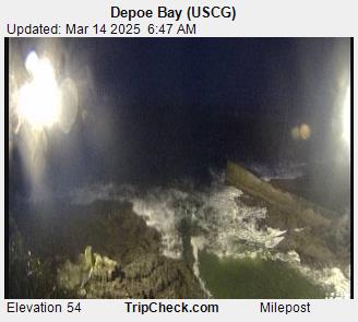
Depoe Bay Channel Weather Cam - mouth of the Bay
CLICK HERE FOR
Buoy Cam - West of Newport
Also see OREGON COAST SKY CAMS / WEB CAMS


CENTRAL OREGON COAST LIVE RADAR
Depoe Bay, Oregon Coast Lodging, Hotels, Motels, Restaurants, Inns, Vacation Rentals
Depoe Bay, Oregon Lodging, Hotels, Motels, Restaurants, Inns, Vacation Rentals
Find places to stay in Depoe Bay; places to eat, dine in Depoe Bay
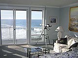
Keystone Vacation Rentals
Oceanfront vacation rental condos in Lincoln City, Depoe Bay
An Ocean Paradise Whales Rendezvous, Depoe Bay
Choose the BnB package or vacation rental package; 50 ft above the ocean
Oregon Coast Inn / Rental With Killer Views, Deep Depoe Bay Vibes
Snuggle Inn is a two-story charmer with two vacation rentals inside
BeachCombersNW.com
Single biggest resource for vacation rentals along the coasts of Washington and Oregon
Ocean House BnB, Newport
Each window ocean view, each room completely different
Restaurant: Tidal Raves
Upscale yet casual, extraordinary seafood, more; for all budgets, tastes
Sirens Oceanfront Restaurant, Depoe Bay / Lincoln City
Renowned breakfast, lunch, dinner with ocean view
Restaurant: Baywalk Cafe
Famed homemade chowder, ocean view, burgers, ice cream
Depoe Bay Restaurants, Dining
Places to eat, Depoe Bay menus, restaurants, dining
BUOY REPORTS Near Depoe Bay
![]()
NDBC - Station NWPO3 - Newport, OR Observations
This feed shows recent marine weather observations from Station NWPO3.
Station NWPO3 - Newport, OR
20 Jun 2026 at 8:05pm
June 20, 2026 7:00 pm PDT
Location: 44.613N 124.067W
Wind Direction: NNW (330°)
Wind Speed: 5.1 knots
Wind Gust: 5.1 knots
Air Temperature: 54.5°F (12.5°C)
![]()
NDBC - Station Observations near 44.61N 124.07W
This feed shows recent marine weather observations from NDBC and its partners within 100 nautical miles of 44.61N 124.07W.
Station NWPO3 - NEWPORT, OR
20 Jun 2026 at 9:03pm
June 20, 2026 6:00 pm PST
Location: 44.613N 124.067W or 0 nautical miles NE of search location of 44.61N 124.07W.
Wind Direction: NNW (330°)
Wind Speed: 5 knots
Wind Gust: 5 knots
Air Temperature: 55°F (12.5°C)
Station SBEO3 - 9435380 - SOUTH BEACH, OR
20 Jun 2026 at 9:03pm
June 20, 2026 6:30 pm PST
Location: 44.625N 124.045W or 1 nautical miles NE of search location of 44.61N 124.07W.
Atmospheric Pressure: 30.09 in (1018.9 mb)
Station 46283 - YAQUINA CHANNEL SW, OR (280)
20 Jun 2026 at 9:03pm
June 20, 2026 6:26 pm PST
Location: 44.567N 124.237W or 8 nautical miles WSW of search location of 44.61N 124.07W.
Significant Wave Height: 8 ft
Dominant Wave Period: 11 sec
Average Period: 8.0 sec
Mean Wave Direction: NNW (337°)
Station 46050 - STONEWALL BANK - 20NM WEST OF NEWPORT, OR
20 Jun 2026 at 9:03pm
June 20, 2026 6:40 pm PST
Location: 44.679N 124.535W or 20 nautical miles WNW of search location of 44.61N 124.07W.
Wind Direction: NNW (340°)
Wind Speed: 12 knots
Wind Gust: 17 knots
Atmospheric Pressure: 30.09 in (1018.9 mb)
Station 46278 - TILLAMOOK BAY SOUTH JETTY, OR (270)
20 Jun 2026 at 9:03pm
June 20, 2026 6:30 pm PST
Location: 45.559N 123.991W or 57 nautical miles N of search location of 44.61N 124.07W.
Significant Wave Height: 7 ft
Dominant Wave Period: 10 sec
Average Period: 7.7 sec
Mean Wave Direction: NW (312°)
Air Temperature: 59°F (15.0°C)
Water Temperature: 58°F (14.6°C)
Station CHAO3 - 9432780 - CHARLESTON, OR
20 Jun 2026 at 9:03pm
June 20, 2026 6:30 pm PST
Location: 43.351N 124.337W or 76 nautical miles S of search location of 44.61N 124.07W.
Wind Direction: NNW (330°)
Wind Speed: 6 knots
Wind Gust: 8 knots
Atmospheric Pressure: 30.08 in (1018.5 mb)
SHIP
20 Jun 2026 at 9:03pm
June 21, 2026 02:00 UTC
Location: 45.5N 122.7W or 79 nautical miles NE of search location of 44.61N 124.07W.
Atmospheric Pressure: 29.97 in (1014.8 mb)
Pressure Tendency: -0.01 in (-0.3 mb)
Air Temperature: 97°F (36.0°C)
Dew Point: 71°F (21.4°C)
Station SNTO3 - TOM'S CREEK, SOUTH SLOUGH RESERVE, OR
20 Jun 2026 at 9:03pm
June 20, 2026 6:30 pm PST
Location: 43.279N 124.318W or 81 nautical miles S of search location of 44.61N 124.07W.
Wind Direction: N (10°)
Wind Speed: 4 knots
Atmospheric Pressure: 30.09 in (1019.0 mb)
Air Temperature: 57°F (14.1°C)
Dew Point: 51°F (10.6°C)
Station 46029 - COLUMBIA RIVER BAR - 20NM WEST OF COLUMBIA RIVER MOUTH
20 Jun 2026 at 9:03pm
June 20, 2026 6:40 pm PST
Location: 46.148N 124.508W or 94 nautical miles N of search location of 44.61N 124.07W.
Wind Direction: WNW (290°)
Wind Speed: 8 knots
Wind Gust: 10 knots
Atmospheric Pressure: 30.07 in (1018.2 mb)
Air Temperature: 58°F (14.2°C)
Dew Point: 55°F (12.8°C)
Water Temperature: 58°F (14.4°C)
Station 46248 - ASTORIA CANYON, OR (179)
20 Jun 2026 at 9:03pm
June 20, 2026 6:26 pm PST
Location: 46.133N 124.64W or 94 nautical miles NNW of search location of 44.61N 124.07W.
Significant Wave Height: 9 ft
Dominant Wave Period: 9 sec
Average Period: 7.5 sec
Mean Wave Direction: NW (320°)
Water Temperature: 58°F (14.7°C)
Station 46243 - CLATSOP SPIT, OR (162)
20 Jun 2026 at 9:03pm
June 20, 2026 6:30 pm PST
Location: 46.215N 124.129W or 96 nautical miles N of search location of 44.61N 124.07W.
Significant Wave Height: 8 ft
Dominant Wave Period: 10 sec
Average Period: 6.9 sec
Mean Wave Direction: WNW (294°)
Air Temperature: 57°F (13.8°C)
Water Temperature: 56°F (13.5°C)
Station ASTO3 - 9439040 - ASTORIA, OR
20 Jun 2026 at 9:03pm
June 20, 2026 6:30 pm PST
Location: 46.207N 123.768W or 97 nautical miles N of search location of 44.61N 124.07W.
Wind Direction: NW (310°)
Wind Speed: 10 knots
Wind Gust: 12 knots
Air Temperature: 59°F (14.9°C)
Station KLMW1 - 9440357 - TEMCO KALAMA TERMINAL, WA
20 Jun 2026 at 9:03pm
June 20, 2026 6:30 pm PST
Location: 45.983N 122.835W or 97 nautical miles NNE of search location of 44.61N 124.07W.
Atmospheric Pressure: 30.01 in (1016.3 mb)
Latest Weather Articles from DEPOE BAY
100 Degrees Coming for Portland, Valley, Gorge, SW Washington
20 Jun 2026 at 4:06pm
Oregon coast may reach 80s; extreme heat watches for valley, Portland - Red Flag Warnings Until Tonight
Gnarly, Somewhat Gruesome Video of Killer Whale Attack on Oregon Coast
19 Jun 2026 at 9:06am
Unusual top-down footage of them hunting a harbor seal. Marine sciences, Seal Rock, Depoe Bay, Newport, Yachats
Absolute Complete Guide to Oregon Coast Fourth of July, 2026: All Towns
19 Jun 2026 at 9:06am
Astoria events, Seaside events, Cannon Beach events, Manzanita events, Rockaway Beach events, Tillamook events, Oceanside events, Pacific City events, Lincoln City events, Depoe Bay events, Newport events, Waldport events, Yachats events, Florence events, Reedsport events, North Bend events, Coos Bay events, Charleston events, Bandon events, Port Orford events, Gold Beach events, Brookings events
Science of Summer Solstice: How It Changes Around Oregon, Washington, the Coast
19 Jun 2026 at 9:06am
The 45th parallel can dictate a few things in this region. Sciences, weather, astronomy
Pacific Northwest Weather | Oregon, Washington, Coastlines - Live View from S...
19 Jun 2026 at 9:06am
See the region live from space. Gateway to Oregon coast, Washington coast, inland Oregon weather, warnings, alerts
Current Conditions in Oregon, Washington, Coastlines - Current Temps
19 Jun 2026 at 9:06am
Updated by Minute: Washington coast and all of Oregon current temperatures, conditions. Weather, sciences
Ontario Eastern Oregon Weather - Forecasts, Sky Cams, Alerts, Current Conditions
15 Jun 2026 at 8:54am
Weather forecasts, sky cams, alerts and current conditions for Ontario in eastern Oregon
Heat Warnings, Advisories Around Oregon, Washington Now Include Coast - Some ...
13 Jun 2026 at 9:54pm
90 to 100 degrees in many areas. Coast sees unusual 80s. Weather, sciences
Astoria / Warrenton Weather
Seaside Weather
Cannon Beach
Manzanita
Nehalem Bay / Wheeler
Rockaway
Oceanside/Tillamook
Pacific City
Lincoln City
Depoe Bay Weather
Newport
Yachats
Florence
Reedsport - Winchester Bay Weather
Coos Bay - North Bend - Charleston
Bandon Weather
Port Orford Weather
Gold Beach Weather
Brookings Weather

Depoe Bay Virtual Tour
A spouting horn downtown, freaky hidden cliffs and whales, whales, whales
Oregon Inland Weather
-- Salem Oregon Weather
-- Portland / Beaverton Oregon Weather
-- Eugene / Springfield Weather
-- Bend Central Oregon Weather
-- Medford Oregon Weather
-- Government Camp / Mt Hood Weather
-- West Columbia River Gorge / Cascade Locks, Oregon Weather
-- Corvallis / Albany Oregon Weather


Search
over 7,5000 Pages for Oregon coast subjects, articles or lodging...
Back to Oregon Coast
Contact Advertise on BeachConnection.net
All Content, unless otherwise attributed, copyright BeachConnection.net Unauthorized use or publication is not permitted
Follow us on


South Coast Hotels
Oregon
Coast Hotels
Astoria/Warrenton Hotels
Seaside
Cannon
Beach Lodging
Nehalem Bay Lodgings
Manzanita Hotels, Lodging
Rockaway Beach Hotels
Three Capes Lodging
Pacific City Hotels, Lodging
Lincoln
City Lodging
Depoe
Bay Lodging
Newport Lodging
Waldport Lodging
Yachats
Lodging
Oregon
Coast Vacation Rentals
Oregon
Coast Lodging Specials
Oregon Coast Luxury Hotels
Oregon Coast Pet Friendly Hotels/Rentals
Oregon
Coast Bed and Breakfasts / B&Bs
Cannon Beach Vacation Rentals
Pacific City Vacation Rentals
Newport, Depoe Bay Vacation Rentals
Oregon Coast Restaurant, Dining
Guide
Seaside
Cannon
Beach Dining
Manzanita,
Rockaway, Wheeler Dining
Pacific
City, Oceanside, Netarts, Tierra Del Mar Restaurants
Tillamook
Bay Restaurants, Dining
Lincoln
City Dining, Restaurants
Depoe
Bay Restaurants, Dining
Newport Restaurants, Dining
Waldport,
Yachats Restaurants, Dining
Florence Restaurants, Dining
Restaurant
Reviews
Coast
Events Calendar
Astoria
Seaside,
Cannon Beach Calendar
Manzanita,
Rockaway Events
Tillamook,
Pacific City Calendar
Lincoln
City Events Calendar
Newport,
Depoe Bay Events Calendar
Yachats Events Calendar
Oregon Coast Weather
Astoria, Warrenton Weather
Seaside Weather
Cannon Beach
Manzanita
Nehalem Bay / Wheeler
Rockaway
Oceanside/Tillamook
Pacific City
Lincoln City
Depoe Bay Weather
Newport
Yachats
Florence
Reedsport - Winchester Bay Weather
Coos Bay - North Bend - Charleston
Bandon Weather
Port Orford Weather
Gold Beach Weather
Brookings Weather
Search for Oregon Coast Subjects, Articles
Explore Every Beach Spot

Astoria
Where the Columbia meets the Pacific, Land of Lewis & Clark and loads of atmosphere & history

Seaside
The Promenade, Tillamook Head, family fun & broad, sandy beaches

Cannon Beach
A mysterious lighthouse, upscale yet earthy, a huge monolith, fine eateries & an art mecca

Nehalem Bay - Manzanita, Rockaway, Wheeler
Manzanita's beaches, Nehalem and Wheeler's quirky beauty; laid back Rockaway

Tillamook Bay
Garibaldi, Barview, Bay City, Tillamook & an oceanfront ghost town

Three Cape Loop - Oceanside, Netarts, Pacific City
The hidden secret of the coast: Cape Meares, a lighthouse, Oceanside, Netarts and Pacific City

Lincoln City & the Corridor of Mystery
Miles & miles of unbroken beaches, Cascade Head, Neskowin and manmade attractions
Depoe Bay
A spouting horn downtown, freaky hidden cliffs and whales, whales, whales

Newport
Two lighthouses, timeless Nye Beach, bustling bayfront, regal bridge

Waldport, Seal Rock
Sands and dunes, craggy Seal Rock, semi-secret beaches

Yachats
Constantly dramatic wave action, a mix of the rugged & upscale

Upper Lane County
25 miles of deserted beaches & oodles of wonders

Florence
A lighthouse, ancient bayfront and miles and miles of fluffy dunes
South Oregon Coast Travel
News Headlines from All Over Oregon Need to scan Oregon headlines? Constantly updated news from all over Oregon: a comprehensive, up-to-the-minute display of news headlines from a variety of media
Oregon Coast Oceanfront Lodging, Hotels, Rentals