Atmospheric River Across Oregon, Washington - Chances of Flooding Seattle to Eugene
Published 12/07/25 at 7:55 a.m.
By Oregon Coast Beach Connection Staff

(Eugene, Oregon) - [UPDATE: Wind advisories in many areas of coast, Gorge, Portland, Pendleton. WORST OF WINDS AND RAIN EXPECTED TONIGHT. Power outages may occur because of saturated ground causing trees to fall, but by and large just an extra-long, wet annoyance. ]
--- From Seattle down to Portland and Eugene, and from the Cascades to the coastlines of Oregon and Washington, an atmospheric river is going to bring an extended period of wet, soggy conditions. It's expected to last all week. (Photo courtesy Lincoln County Sheriff's - file photo from a past incident near Otis)
Includes exclusive listings; some specials in winter
In Cannon Beach:
Includes rentals not listed anywhere else
In Manzanita, Wheeler, Rockaway Beach:
Some specials for winter
In Pacific City, Oceanside:
Some specials for winter
In Lincoln City:
Some specials for winter
In Depoe Bay, Gleneden Beach:
Some specials for winter
In Newport:
Look for some specials
In Waldport
Some specials for winter
In Yachats, Florence
Some specials for winter
Southern Oregon Coast Hotels / Lodgings
Reedsport to Brookings, places to stay; winter deals
Talk about raining on your parade: the Space Weather Prediction Center is also predicting some heavy solar wind activity, which may well result in aurora borealis sightings as far south as Oregon on Tuesday. It's doubtful anyone gets to see that.
The National Weather Service (NWS) offices in Seattle, Portland and Medford have all issued similar statements about the coming soaker. A flood watch is in effect from Sunday through late Thursday for much of the Pacific Northwest, including all of western Washington and most of western Oregon. River and urban flooding caused by excessive rainfall is possible. Landslides may occur in areas of steep terrain, and debris flows are possible over recently burned ground.
In Oregon, the watch covers Clatsop, Columbia, Tillamook, Washington, Multnomah, Hood River, Yamhill, Clackamas, Polk, Marion, Lincoln, Benton, Linn, and Lane counties. In Washington, it includes Pacific, King, Wahkiakum, Cowlitz, Skamania, and Clark counties.
The heaviest rains happen Sunday through Wednesday, with lighter amounts on Thursday. Rivers draining the coastal mountains and several Willamette tributaries have the highest chance of flooding, estimated at 40 to 80 percent. Flooding along the Willamette mainstem remains unlikely, with chances around 10 percent. See all Oregon Inland Weather
"Rainfall amounts up to 10" are possible within the Olympics, Cascades, and coastal ranges," the NWS said.

Courtesy NWS
Widespread impacts are not expected through Sunday, the NWS said. However, if rainfall rates hold steady around 0.2 to 0.3 inches per hour for several hours, smaller and more responsive basins in Washington State - such as the Grays at Rosburg and the Willapa River - could rise quickly. Inland gusts will generally be in the 30 - 40 mph range, strongest along exposed coastal areas and higher terrain. This system sets the stage for a more active stretch in the days ahead, when several inches of rain may fall across northwest Oregon and southwest Washington, raising the risk of both river flooding and localized urban flooding.
Rivers are most likely to rise in the Washington Cascades, the NWS said.
Beach Towns
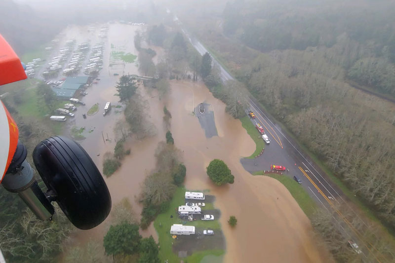
Photo USCG - file photo from a past incident at Neskowin
Sizably high seas are likely coming to the Oregon and Washington coast, which could spell more dangers on the beaches. However, weather will be gnarly enough you'll likely want to stick to watching the show from a hotel room.
“There is a 70% chance for stronger Gale Force winds to materialize across the waters Monday,” the NWS said. “This will push seas into the mid teens Monday afternoon with a 10-20% chance of seas climbing to at least 17-18 by 4pm Monday.”
Seas stand a far less chance of getting really high later in the week, in spite of otherwise stormy conditions.
Southern Oregon and Coast
This persistent storm track will bring periods of rain to Coos and Douglas counties Sunday through Wednesday, with the heaviest rainfall expected Monday night into Wednesday. Impact may not be as harsh as farther north.
Totals of 2 to 4 inches are likely, especially across northern Coos and Douglas near the Lane County border, while lesser amounts fall south of Roseburg. Rivers remain unusually low for this time of year, and flooding is not forecast. Still, water levels could rise quickly midweek, the NWS said, and those in areas such as Reedsport, Bandon or Medford should keep an eye on weather reports. See Oregon Coast Weather
Aurora Chances
Meanwhile, above it all there is predicted to be some amount of northern lights activity, with a geomagnetic storm category G3 predicted sometime Tuesday.
“Aurora may be seen as low as Pennsylvania to Iowa to Oregon,” the SWPC said.
Timing is as yet unclear.
For full weather forecasts as well as wave forecasts for each area:
Astoria / Warrenton Weather
Seaside Weather
Cannon Beach
Manzanita Weather / Waves
Nehalem Bay / Wheeler
Rockaway Beach Waves, Weather
Oceanside/Tillamook
Pacific City Weather, Waves
Lincoln City Waves, Weather
Depoe Bay Weather
Newport Waves, Weather
Yachats
Florence
Coos Bay - North Bend - Charleston
Bandon Weather
Port Orford Weather
Gold Beach Weather
Brookings Weather
Oregon Coast Hotels for this event - South Coast Hotels - Oregon Coast Vacation Rentals - Where to eat - Maps - Virtual Tours


Oregon Coast Vacation Rentals
Oregon Coast Lodging Specials


OREGON COAST HOTEL REVIEWS (hit refresh to see different reviews)
Multiple, Killer Oregon Coast Balcony Views at a Mere Two of Newport's Hotspots
A slice of infnity at one and a charming mansion in dense woods. Newport hotel reviews
April Gets Even Cheaper Midweek at Depoe Bay, Lincoln City: Oregon Coast Deals
Off-season rates plus more at Keystone Vacation Rentals. Depoe Bay lodging specials, Lincoln City hotel reviews, Newport hotel reviews
South Oregon Coast Hotels
S. Coast Hotels: Reedsport, Winchester Bay, Coos Bay, Bandon, Gold Beach, Brookings. S Coast Hotel Reviews
Newport Hotels - Nye Beach, South Beach
Newport Hotel reviews, Newport vacation rentals
More About Oregon Coast hotels, lodging.....
More About Oregon Coast Restaurants, Dining.....
 |
 |
 |
Washington Coast / Oregon Coast Articles (stories are random: hit reload to see different articles)
Video: Orcas Bouncing, Jumping Out of the Surf in Spectacular Oregon Coast Display19 Jun 2026 at 9:06am
Seal Rock was the site of wild jumps, tail slaps. Marine sciences. Whale
N. Oregon Coast: Oceanside Videos and Reels
8 Jun 2026 at 12:09am
Oceanside's tunnel, history, vibes, even weird stuff and odd sounds. Travel tips
NASA Soon to Announce More Plans of Missions to the Moon, Gamma Ray Research
22 May 2026 at 9:34pm
Announcements day after Memorial Day; more on robotic LINK satellite coming. Astronomy, sciences
First Weekend in June is Free Fishing for Washington Lakes, Rivers, the Coast
1 Jun 2026 at 10:05pm
Giving residents a chance to fish for many species without purchasing a license. Washington coast events
Stuck on Oregon Coast Cliff, Easily-Spooked Dog Makes Rescue Tense for Cannon Beach Responders
8 Jun 2026 at 12:09am
The husky was stuck on a steep cliff at Ecola State Park. Rescue, safety
Tragic Crash Near Oregon Coast Range; Washington County K-9 Nabs Thief
16 May 2026 at 8:00am
A Lincoln City man died in a wreck in Yamhill County. Crime, traffic, safety
Still Some Summer Lodging Deals on Oregon Coast
10 Jun 2026 at 1:01pm
Found in Manzanita and Lincoln City - where to look for more. Lincoln City hotel specials, Manzanita hotel specials. Ocean Inn, A1 Beach Rentals. Lincoln City reviews, Manzanita reviews
Lincoln City's Travel Officials: How to Keep Safe on Oregon's Coast
24 May 2026 at 9:27pm
From the obvious to the easy-to-overlook. Safety, traffic
Back to Oregon Coast
Contact Advertise on Oregon Coast Beach Connection
All Content, unless otherwise attributed, copyright © Oregon Coast Beach Connection. Unauthorized use or publication is not permitted

Oregon
Coast Hotels
S. Coast Hotels
Astoria/Warrenton Hotels
Seaside Hotels
Cannon
Beach Hotels
Nehalem Bay Lodgings
Manzanita Hotels, Lodging
Rockaway Beach Hotels
Three Capes Lodging
Pacific City Hotels, Lodging
Lincoln
City Lodging
Depoe
Bay Hotels
Newport Hotels
Waldport Lodging
Yachats
Hotels
Florence Hotels
Reedsport Hotels
Coos Bay Hotels
Bandon Hotels
Port Orford Hotels
Gold Beach Hotels
Brookings Hotels
Oregon
Coast Vacation Rentals
Oregon
Coast Lodging Specials
South Coast Hotels
Dining
Guide
Seaside
Cannon
Beach Dining
Manzanita,
Rockaway, Wheeler Dining
Pacific
City, Oceanside, Netarts, Tierra Del Mar Restaurants
Tillamook
Bay Restaurants, Dining
Lincoln
City Dining, Restaurants
Depoe
Bay Restaurants, Dining
Newport Restaurants, Dining
Waldport,
Yachats Restaurants, Dining
Florence Restaurants, Dining
Restaurant
Reviews
Coast
Events Calendar
Astoria
Seaside,
Cannon Beach Calendar
Manzanita,
Rockaway Events
Tillamook,
Pacific City Calendar
Lincoln
City Events Calendar
Newport,
Depoe Bay Events Calendar
Yachats Events Calendar
Oregon Coast Complete Guides every beach access, attraction
Search for Oregon Coast Subjects, Articles
Explore Every Beach Spot


News Headlines from All Over Oregon Need to scan Oregon headlines? Constantly updated news from all over Oregon: a comprehensive, up-to-the-minute display of news headlines from a variety of media
Oregon Coast Oceanfront Lodging, Hotels, Rentals