Snow Continues Through Thurs for Oregon, Washington, Cascades, Coast Range and Beaches
Published 02/18/26 at 8:55 p.m.
By Oregon Coast Beach Connection Staff
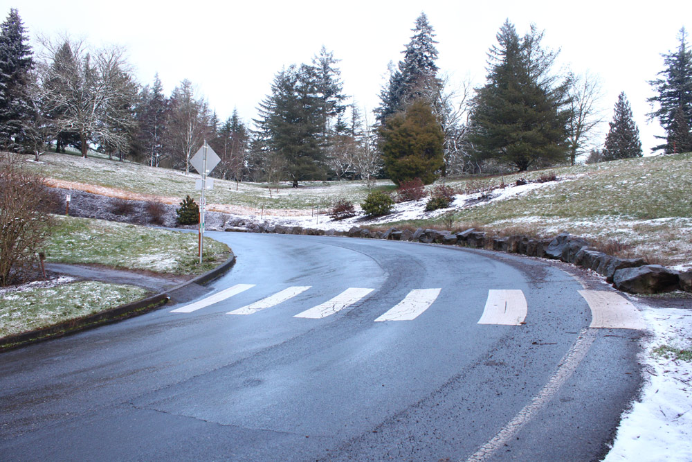
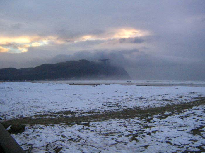
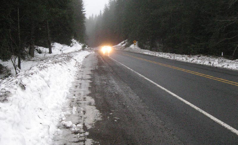
(Portland, Oregon) - After a day and night of widespread snowfall across Oregon and Washington - including the coast, higher elevations around Portland, Vancouver, and the Cascades - forecasters say more winter weather is on the way. (Photos Oregon Coast Beach Connection. Above: Portland in the snow)
Includes exclusive listings; some specials in winter
In Cannon Beach:
Includes rentals not listed anywhere else
In Manzanita, Wheeler, Rockaway Beach:
Some specials for winter
In Pacific City, Oceanside:
Some specials for winter
In Lincoln City:
Some specials for winter
In Depoe Bay, Gleneden Beach:
Some specials for winter
In Newport:
Look for some specials
In Waldport
Some specials for winter
In Yachats, Florence
Some specials for winter
Southern Oregon Coast Hotels / Lodgings
Reedsport to Brookings, places to stay; winter deals
However, no major issues are expected for lower elevations, where any snow will melt soon.
LATEST FROM NWS: Forecasters now expect the surface low to track toward the north Oregon coast, a shift that favors little to no snow accumulation below 500 feet in the Willamette Valley, the Portland metro area, and along the coast. Southerly winds are expected to hold temperatures above freezing in lower elevations, limiting snow potential.
Higher terrain tells a different story. Elevations above 500 feet are expected to see accumulating snow with travel impacts likely. One exception remains for lower elevations: a dusting to one inch of wet snow is still possible in localized areas where heavier showers develop, though any impacts would likely be brief.
Areas most favored to see at least some accumulating snow - including spots below 500 feet - include Longview, Kelso, Ridgefield, Scappoose, St. Helens, Banks, Timber, the West Hills of Portland, and the Chehalem region.
A winter weather advisory remains in effect until 4 a.m. Friday for the Foothills of the Northern and Central Oregon Cascades, the North and Central Coast Range Mountains of Oregon, the Willapa Hills, and the South Washington Cascade Foothills. Roads - especially bridges and overpasses - are expected to become slick and hazardous.
Oregon Coast Weather -- See Oregon Coast Highway 101 / Coast Range Traffic
“We are very confident (85-90% chance) that freezing rain and/or very gusty winds will not occur with this system, no matter the track the low takes,” the NWS said. “Also, no matter the track, snow accumulations for the Cascades and Coast Ranges look to be on track as hazardous travel conditions are expected to continue through the work week. We are expecting additional snow accumulations of 2 to 7 inches through Wednesday night and another 1 to 3 inches of snow Thursday morning through Thursday night for the Foothills of the Northern and Central Oregon Cascades, North and Central Coast Range Mountains of Oregon, Willapa Hills, and South Washington Cascade Foothills.”
Some 4 to 9 inches will hit the south Washington Cascades and northern and central Cascades of Oregon on Wednesday, with more snow Thursday. After that a steady warming period kicks in.
Also see
Oregon Inland Weather- McMinnville, Oregon Weather
-- Salem Oregon Weather
-- Portland / Beaverton Oregon Weather
-- Eugene / Springfield Weather
-- Bend Central Oregon Weather
-- Medford Oregon Weather
-- Government Camp / Mt Hood Weather
-- West Columbia River Gorge / Cascade Locks, Oregon Weather
-- Corvallis / Albany Oregon Weather
Oregon Coast Hotels for this event - South Coast Hotels - Oregon Coast Vacation Rentals - Where to eat - Maps - Virtual Tours


OREGON COAST HOTEL REVIEWS (hit refresh to see different reviews)
Nye Beach's Waves Hotel Keeps Making Waves: an Oregon Coast Classic
Less expensive than many, an innovative Newport boutique hotel. Newport lodging reviews
Kiwanda Coastal Properties - Pacific City Hotel Reviews
Rates rock bottom now, but for an extra 10 perc use code 'BEACHCONNECT'. Click to see
Exquisite Spring Break Hangouts on Oregon Coast with New Discoveries
The wows of Lincoln City and Cannon Beach, including the beginning of a ghost forest. Lincoln City hotel reviews, Cannon Beach hotel reviews, specials, Seaside hotel reviews
New to Oregon Coast Vacation Home Scene: Latest Finds in Neskowin, Pacific City
Four new vacation rentals in Neskowin and Pacific City. Pacific City hotel reviews, Neskowin hotel reviews
More About Oregon Coast hotels, lodging.....
More About Oregon Coast Restaurants, Dining.....
 |
 |
 |
Washington Coast / Oregon Coast Articles (stories are random: hit reload to see different articles)
Bloom Newport Brings Live Music and Food to Central Oregon Coast Town in MayNewport Performing Arts Center on May 16, 2026, going from 3 to 7 p.m. Newport events
Densely Layered Acoustic Pop: Antonelli Hits Oregon Coast's Bandon and Astoria
10 Jun 2026 at 7:01am
Bandon June 13, Astoria?s Xanadu June 29. Astoria events, Bandon events
Oregon Coast This Weekend: Wildfire, Oil Spill, DUII on the Dunes, Fatal Crash
1 Jun 2026 at 10:05pm
Incidents in Astoria, Winchester Bay, Dune City, Cloverdale, Tillamook. Traffic, crime, US Coast Guard
Nighttime Traffic Delays Coming to North Oregon Coast's Youngs Bay Bridge
30 May 2026 at 7:01am
Also part of the Oregon 42: U.S. 101 to Cedar Point Road project. Astoria, Coos Bay
Tragic Crash Near Oregon Coast Range; Washington County K-9 Nabs Thief
16 May 2026 at 8:00am
A Lincoln City man died in a wreck in Yamhill County. Crime, traffic, safety
2026 Elections: Oregon's Measure 120 Goes Down Fast - At Least So Far
20 May 2026 at 12:34am
Controversial gas tax is out, says Associated Press. Traffic
World's Largest Creature: Skeleton Assembled and Now Open at Oregon Coast's Hatfield Marine Life Center
22 May 2026 at 9:34pm
New landmark rising in Newport: the fully assembled skeleton of a 70-foot blue whale. Newport events
Super Moon, Blue Moon, Micro Moon and Meteor Shower - All Above Oregon / Washington Coast
Why we'll be getting extreme large and minus tides, plus meteors and more. Astronomy, weather. Brookings events, Gold Beach events, Port Orford events, Coos Bay events, Bandon events, Florence events, Yachats events, Newport events, Lincoln City events, Rockaway Beach events, Manzanita events, Cannon Beach events, Seaside events, Astoria events
Back to Oregon Coast
Contact Advertise on Oregon Coast Beach Connection
All Content, unless otherwise attributed, copyright © Oregon Coast Beach Connection. Unauthorized use or publication is not permitted

Oregon
Coast Hotels
S. Coast Hotels
Astoria/Warrenton Hotels
Seaside Hotels
Cannon
Beach Hotels
Nehalem Bay Lodgings
Manzanita Hotels, Lodging
Rockaway Beach Hotels
Three Capes Lodging
Pacific City Hotels, Lodging
Lincoln
City Lodging
Depoe
Bay Hotels
Newport Hotels
Waldport Lodging
Yachats
Hotels
Florence Hotels
Reedsport Hotels
Coos Bay Hotels
Bandon Hotels
Port Orford Hotels
Gold Beach Hotels
Brookings Hotels
Oregon
Coast Vacation Rentals
Oregon
Coast Lodging Specials
South Coast Hotels
Dining
Guide
Seaside
Cannon
Beach Dining
Manzanita,
Rockaway, Wheeler Dining
Pacific
City, Oceanside, Netarts, Tierra Del Mar Restaurants
Tillamook
Bay Restaurants, Dining
Lincoln
City Dining, Restaurants
Depoe
Bay Restaurants, Dining
Newport Restaurants, Dining
Waldport,
Yachats Restaurants, Dining
Florence Restaurants, Dining
Restaurant
Reviews
Coast
Events Calendar
Astoria
Seaside,
Cannon Beach Calendar
Manzanita,
Rockaway Events
Tillamook,
Pacific City Calendar
Lincoln
City Events Calendar
Newport,
Depoe Bay Events Calendar
Yachats Events Calendar
Oregon Coast Complete Guides every beach access, attraction
Search for Oregon Coast Subjects, Articles
Explore Every Beach Spot


News Headlines from All Over Oregon Need to scan Oregon headlines? Constantly updated news from all over Oregon: a comprehensive, up-to-the-minute display of news headlines from a variety of media
Oregon Coast Oceanfront Lodging, Hotels, Rentals