Weather Will Be a Handful for Northern Oregon, South Washington: Flood Watches, Winds
Published 03/12/26 at 12:55 a.m.
By Oregon Coast Beach Connection Staff

(Portland, Oregon) – There's a boatload of flood, wind and even snow alerts for various parts of Oregon and Washington, as an atmospheric river already moving across the region will drive impacts over the next several days. Look for periods of moderate to heavy rain, breezy conditions, and mountain snow focused mainly on the Washington Cascades. The overall risk of general river flooding remains low, but there are various watches, according to the National Weather Service (NWS). (Above: St. John's Bridge in Portland - Oregon Coast Beach Connection)
Includes exclusive listings; some specials in winter
In Cannon Beach:
Includes rentals not listed anywhere else
In Manzanita, Wheeler, Rockaway Beach:
Some specials for winter
In Pacific City, Oceanside:
Some specials for winter
In Lincoln City:
Some specials for winter
In Depoe Bay, Gleneden Beach:
Some specials for winter
In Newport:
Look for some specials
In Waldport
Some specials for winter
In Yachats, Florence
Some specials for winter
Southern Oregon Coast Hotels / Lodgings
Reedsport to Brookings, places to stay; winter deals
Even sim there's a dose of spring coming with temps possibly getting into the upper '60s next week.
There are no watches or warnings south of Albany or Madras. Here are the watches and warnings issued by the NWS.
Winter Weather Advisory for the North Oregon Cascades
A Winter Weather Advisory remains in effect until 11 p.m. Thursday for the North Oregon Cascades. Wet snow will vary sharply by elevation, with three to twelve inches expected between 3,000 and 5,000 feet. Locations above 5,500 feet could see several feet of heavy, wet snow. Roads, bridges, and overpasses are likely to become slick and hazardous. See all warnings for Oregon.
A Flood Watch is in effect through early Saturday morning for the Wilson and Trask Rivers near Tillamook. The Trask River is expected to rise rapidly, with minor flooding beginning above 16.5 feet. Dairy farms, buildings, and a few residences near Highway 101 may be threatened. The river measured 10.2 feet Wednesday afternoon, and forecasters say it may reach flood stage late Wednesday night.
Widespread Flood Watch for Northwest Oregon and Southwest Washington:
A broader Flood Watch covers much of northwest Oregon and southwest Washington from Wednesday evening through Friday night. That includes the Washington coast and north Oregon coast. Excessive rainfall may cause flooding of rivers, creeks, and urban areas. Landslides and debris flows are possible, especially near steep slopes and canyon mouths. The watch includes Clackamas County Cascade Foothills, Clatsop County Coast, East Central Willamette Valley, East Portland Metro, Inner Portland Metro, Lower Columbia River, North Oregon Coast Range, North Oregon Coast Range Lowlands, Outer Southeast Portland Metro, Portland West Hills and Chehalem Mountain, Tillamook County Coast, Tualatin Valley, West Central Willamette Valley, West Columbia River Gorge I-84 Corridor and West Columbia River Gorge of Oregon above 500 ft and southwest Washington, including the following areas, Cowlitz County Lowlands, East Clark County Lowlands, Inner Vancouver Metro, North Clark County Lowlands, South Washington Cascade Foothills, West Columbia River Gorge SR 14 Corridor, Willapa Hills and Willapa and Wahkiakum Lowlands.
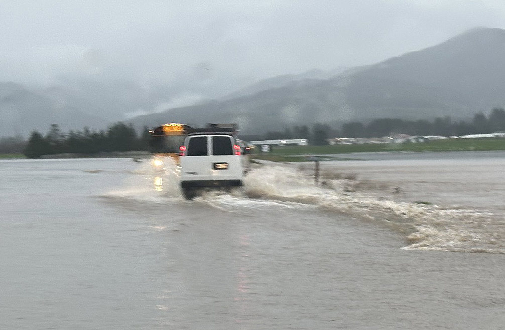
Near Tillamook last year - courtesy Tillamook County Sheriff's Office
A Flood Watch continues for Johnson Creek at Sycamore from Thursday morning through early Saturday. Minor flooding begins at 11.0 feet, affecting areas between SE 92nd and SE 122nd and between Johnson Creek and SE Harold Street. The creek stood at 3.2 feet late Wednesday morning, with forecasts indicating a rise to flood stage Thursday.
A separate Flood Watch remains in effect for the Pudding River at Aurora from Saturday evening through late Monday. Minor flooding begins above 22.0 feet, affecting low-lying agricultural land and access roads. The river was at 10.0 feet Wednesday morning and is expected to rise toward flood stage over the weekend.
High Wind Warning for Eastern Oregon and Washington:
A High Wind Warning is in effect from 5 p.m. Wednesday through 11 a.m. Thursday for the Foothills of the Blue Mountains, the Lower Columbia Basin, and North Central Oregon. Southwest winds of 25 to 35 mph with gusts up to 60 mph may bring down trees and power lines. Travel may be difficult for high-profile vehicles, and blowing dust could reduce visibility in exposed areas.
There are a variety of other snow and inclement weather alerts for Oregon and Washington. See them at the Oregon Coast Weather page or the Full Oregon Weather: North, Central, Eastern Southern page.
Oregon Coast Hotels for this event - South Coast Hotels - Oregon Coast Vacation Rentals - Where to eat - Maps - Virtual Tours


OREGON COAST HOTEL REVIEWS (hit refresh to see different reviews)
Three Distinctive, Unique Places to Spend the Night in Pacific City - N. Oreg...
One in Neskowin, two rentals homes in town. Lodging reviews, hotel reviews
Making the Ordinary a Special Occasion at Lincoln City's Inn at Wecoma - Cent...
The inn features standout special packages and is pup friendly. Lincoln City hotel reviews, specials
A1 Beach Rentals - Reviews of Lincoln City
Not far from Neskowin or Depoe Bay: amazing oceanfront option or near the ocean. Often the least expensive rental agency in the region
Central Oregon Coast's Summerlike Sept and Oct Getting Booked Up - Some Renta...
Lincoln City's Keystone: brief rental openings in Sept, slightly more Oct. Lincoln City hotel reviews. Depoe Bay hotel reviews
More About Oregon Coast hotels, lodging.....
More About Oregon Coast Restaurants, Dining.....
 |
 |
 |
Washington Coast / Oregon Coast Articles (stories are random: hit reload to see different articles)
Tuesday Night30 Jun 2026 at 7:00pm
39°F - Mostly Clear
Wednesday Night
1 Jul 2026 at 7:00pm
41°F - Mostly Clear
Wednesday
1 Jul 2026 at 7:00am
72°F - Sunny
Tuesday
30 Jun 2026 at 7:00am
72°F - Sunny
Today
29 Jun 2026 at 7:00am
70°F - Partly Sunny
Tonight
29 Jun 2026 at 7:00pm
43°F - Partly Cloudy
Back to Oregon Coast
Contact Advertise on Oregon Coast Beach Connection
All Content, unless otherwise attributed, copyright © Oregon Coast Beach Connection. Unauthorized use or publication is not permitted

Oregon
Coast Hotels
S. Coast Hotels
Astoria/Warrenton Hotels
Seaside Hotels
Cannon
Beach Hotels
Nehalem Bay Lodgings
Manzanita Hotels, Lodging
Rockaway Beach Hotels
Three Capes Lodging
Pacific City Hotels, Lodging
Lincoln
City Lodging
Depoe
Bay Hotels
Newport Hotels
Waldport Lodging
Yachats
Hotels
Florence Hotels
Reedsport Hotels
Coos Bay Hotels
Bandon Hotels
Port Orford Hotels
Gold Beach Hotels
Brookings Hotels
Oregon
Coast Vacation Rentals
Oregon
Coast Lodging Specials
South Coast Hotels
Dining
Guide
Seaside
Cannon
Beach Dining
Manzanita,
Rockaway, Wheeler Dining
Pacific
City, Oceanside, Netarts, Tierra Del Mar Restaurants
Tillamook
Bay Restaurants, Dining
Lincoln
City Dining, Restaurants
Depoe
Bay Restaurants, Dining
Newport Restaurants, Dining
Waldport,
Yachats Restaurants, Dining
Florence Restaurants, Dining
Restaurant
Reviews
Coast
Events Calendar
Astoria
Seaside,
Cannon Beach Calendar
Manzanita,
Rockaway Events
Tillamook,
Pacific City Calendar
Lincoln
City Events Calendar
Newport,
Depoe Bay Events Calendar
Yachats Events Calendar
Oregon Coast Complete Guides every beach access, attraction
Search for Oregon Coast Subjects, Articles
Explore Every Beach Spot


News Headlines from All Over Oregon Need to scan Oregon headlines? Constantly updated news from all over Oregon: a comprehensive, up-to-the-minute display of news headlines from a variety of media
Oregon Coast Oceanfront Lodging, Hotels, Rentals