Extreme Sneaker Wave Danger on S. Oregon Coast, Yet All of Coast Sunny, Near 70 This Week
Published 10/17/23 at 4:52 a.m.
By Oregon Coast Beach Connection staff
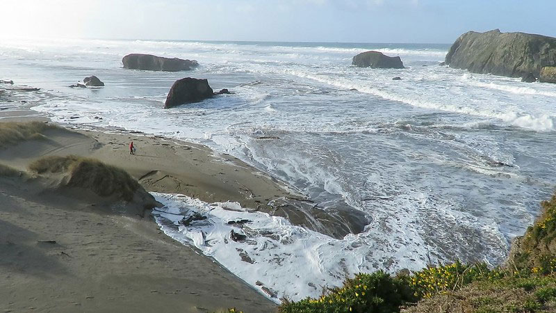
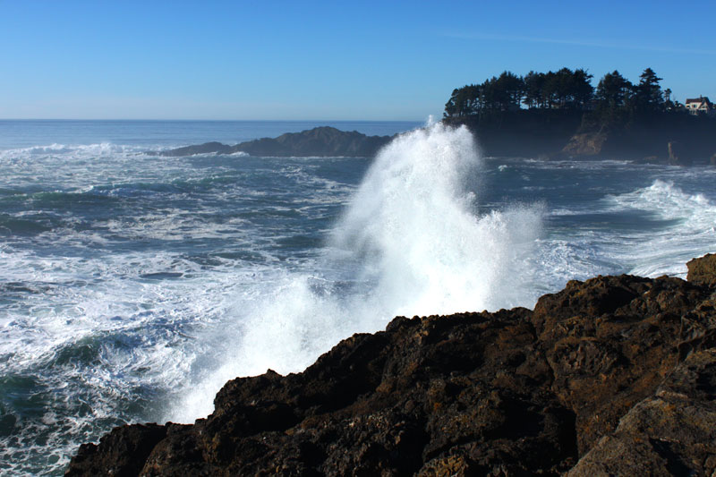
(Coos Bay, Oregon) – From Reedsport down through Brookings, there will be “an extreme sneaker wave threat” for the entire south Oregon coast, with the National Weather Service (NWS) saying not to go on beaches Tuesday night through Wednesday evening. While the northern half of the shoreline won't be quite as unruly, wave height is falling just below warning levels. (Photo courtesy Gleneda Borton / King Tides: Bandon at extreme tides)
Ironically, all this will be happening as the entire Oregon coast gets really sunny for the next few days, with unseasonably warm temps, especially down south where it will get as high as the mid 70s. There's a good run all along the coast of sunny conditions for Tuesday through Friday, even though sneaker waves in the south will make the beaches too dangerous.
Includes exclusive listings; some specials in winter
In Cannon Beach:
Includes rentals not listed anywhere else
In Manzanita, Wheeler, Rockaway Beach:
Some specials for winter
In Pacific City, Oceanside:
Some specials for winter
In Lincoln City:
Some specials for winter
In Depoe Bay, Gleneden Beach:
Some specials for winter
In Newport:
Look for some specials
In Waldport
Some specials for winter
In Yachats, Florence
Some specials for winter
Southern Oregon Coast Hotels / Lodgings
Reedsport to Brookings, places to stay; winter deals
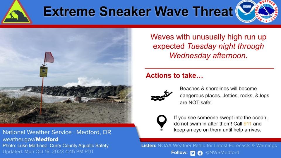
The NWS said on social: “Tuesday night through Wednesday afternoon will NOT be a good time to be walking the beach.”
They also issued a special weather statement – which is just shy of a warning.
“Waves can run up significantly farther on a beach than normal, including over rocks and jetties,” the NWS said. “These sneaker waves can suddenly knock people off of their feet and quickly pull them into the cold ocean waters, resulting in serious injury or death.”
The culprit is a big swell from the west with a high period timing of 20 seconds coming in on Wednesday, according to the NWS. This refers to the timing between waves. If that timing is the mid teens or higher, waves can build up considerable power by bunching together into one much larger wave. Hence, a sneaker wave.
20 seconds is an extreme number for timing – rather unusual. The timing and wave height are considerable on the north Oregon coast as well, but just below the sneaker wave statement threshold, even though timing is at a whopping 24 seconds sometimes.
However, for now, the NWS is concentrating its warnings for the southern beaches in a statement made at 2 a.m. on Tuesday.
“While tonight there will be a high risk for sneaker waves, the risk increases to extreme around 5 AM PDT Wednesday and lasts into the afternoon,” the NWS said. “We are anticipating the sneaker wave risk to decrease later Wednesday evening as the period decreases and an overlapping swell 'merges' into one wave group by Thursday.”
Basic Forecast:
Tuesday: sunny with highs in low to mid 70s on south coast, upper 60s on north coast.
Wednesday: forecast is nearly identical.
Thursday: Same.
Friday: Mostly sunny with highs more in the 60s for both areas.
With such warm temps close to the mid 70s and sunny skies, it will be tempting to wander the beaches of the south coast. Do not do so. Stay on high ground and watch the spectacle.
Suggestion: Shore Acres by Coos Bay should be nearly maniacal.
Even up north, be prepared for sneaker waves in areas like Florence, Newport or Seaside. The NWS is looking at some rather extraordinary wave patterns.
“We continue to monitor the progress of a large swell train associated with a strong Aleutian low that will move into the Gulf of Alaska Tuesday,” the NWS said of the north coast. “While there are no ship reports nearby as ships are wisely avoiding this storm, wave heights on the order of 40-50 feet were modeled for swell generation region of this storm. While wave heights will be nowhere near that by the time these waves arrive at the coast, they will likely only decay to around 13-16 ft by the time they reach the US West Coast.
See Washington Coast Weather - Oregon Coast Weather
“Forerunner swells on the order of 5-8 ft with dominant periods of 20-24 seconds are currently forecast for the coast Wednesday, which will result in a highly elevated threat of sneaker waves during a period of nice warm and sunny beach weather.”
On Wednesday, conditions up north get a little more dicey.
“Wednesday night into Thursday, periods decrease to 16-19 seconds, but swell height increases to 13-16 ft. While this remains below High Surf Advisory criteria, the concurrence with some of the higher tides of the month could lead to significant runup and potentially minor beach erosion as these waves reach shore.”
In short, from Florence northward it is a time of caution on the beaches as well. This may well turn into beach hazard warnings for that area too.
Oregon Coast Hotels for this event - South Coast Hotels - Where to eat - Maps - Virtual Tours


Cannon Beach Lodging
Nehalem Bay Lodgings
Manzanita Hotels, Lodging
Three Capes Lodging
Pacific City Hotels, Lodging
Lincoln City Lodging
Depoe Bay Lodging
Newport Lodging
Waldport Lodging
Yachats Lodging
Oregon Coast Vacation Rentals
Oregon Coast Lodging Specials


More About Oregon Coast hotels, lodging.....
More About Oregon Coast Restaurants, Dining.....


 Andre' GW Hagestedt is editor, owner and primary photographer / videographer of Oregon Coast Beach Connection, an online publication that sees over 1 million pageviews per month. He is also author of several books about the coast.
LATEST Related Oregon Coast Articles
27 Jun 2026 at 11:23pm
The man was taken to a burn center in Portland. Video of lightning by satellite. Molalla, Clackamas County, Marion County, Wilsonville
Oregon Coast Jazz Party Announces Lineup in Newport - October
27 Jun 2026 at 11:23pm
October 2 - 4 in Nye Beach, Newport. Newport events
Oregon Officials Advice on Fireworks, Leave Them At Home If Heading to State ...
27 Jun 2026 at 11:23pm
Fireworks are banned in all state parks; Sheriffs urge caution. Safety. Astoria events, Seaside events, Cannon Beach events, Manzanita events, Rockaway Beach events, Tillamook events, Oceanside events, Pacific City events, Lincoln City events, Depoe Bay events, Newport events, Waldport events, Yachats events, Florence events, Reedsport events, North Bend events, Coos Bay events, Charleston events, Bandon events, Port Orford events, Gold Beach events, Brookings events. Weather
Absolute Complete Guide to Oregon Coast Fourth of July, 2026: All Towns
26 Jun 2026 at 6:51am
Astoria events, Seaside events, Cannon Beach events, Manzanita events, Rockaway Beach events, Tillamook events, Oceanside events, Pacific City events, Lincoln City events, Depoe Bay events, Newport events, Waldport events, Yachats events, Florence events, Reedsport events, North Bend events, Coos Bay events, Charleston events, Bandon events, Port Orford events, Gold Beach events, Brookings events. Weather
Pirate Invasion, Curry County Fair and Wild Mushrooms Dot S. Oregon Coast Lan...
26 Jun 2026 at 6:51am
Fair in Gold Beach July 23 - 26; Pirates of Pacific Fest Aug 7 - 9; Wild Rivers Mushroom Fest Nov 7 - 8. Brookings events, Gold Beach events
Manzanita in July: History of Oregon Coast's 101 and Pirate-Themed Scavenger ...
26 Jun 2026 at 6:51am
July 9: Scavenger Hunt. July 11: History of Highway. Manzanita events, Nehalem events, Cannon Beach events, Tillamook events
Oregon Coast News Roundup: Dead Whale, Fatal Vehicle Wreck, Arrests
26 Jun 2026 at 6:51am
19th deceased whale this year; fatal collision Yamhill County. Seaside, marine sciences, Gearhart, Newberg, traffic, true crime
Famous Orcas from Alaskan Rescue Effort Pop Up on Oregon Coast, Blowing Up So...
26 Jun 2026 at 6:51am
The pair were stuck in a lake in 2023 and freed by elaborate means. Marine sciences, Newport
Back to Oregon Coast
Contact Advertise on Oregon Coast Beach Connection
All Content, unless otherwise attributed, copyright Oregon Coast Beach Connection. Unauthorized use or publication is not permitted

Oregon
Coast Hotels
S. Coast Hotels
Astoria/Warrenton Hotels
Seaside Hotels
Cannon
Beach Hotels
Nehalem Bay Lodgings
Manzanita Hotels, Lodging
Rockaway Beach Hotels
Three Capes Lodging
Pacific City Hotels, Lodging
Lincoln
City Lodging
Depoe
Bay Hotels
Newport Hotels
Waldport Lodging
Yachats
Lodging
Oregon
Coast Vacation Rentals
Oregon
Coast Lodging Specials
South Coast Hotels
Dining
Guide
Seaside
Cannon
Beach Dining
Manzanita,
Rockaway, Wheeler Dining
Pacific
City, Oceanside, Netarts, Tierra Del Mar Restaurants
Tillamook
Bay Restaurants, Dining
Lincoln
City Dining, Restaurants
Depoe
Bay Restaurants, Dining
Newport Restaurants, Dining
Waldport,
Yachats Restaurants, Dining
Florence Restaurants, Dining
Restaurant
Reviews
Coast
Events Calendar
Astoria
Seaside,
Cannon Beach Calendar
Manzanita,
Rockaway Events
Tillamook,
Pacific City Calendar
Lincoln
City Events Calendar
Newport,
Depoe Bay Events Calendar
Yachats Events Calendar
Oregon Coast Complete Guides every beach access, attraction
Search for Oregon Coast Subjects, Articles
Explore Every Beach Spot


News Headlines from All Over Oregon Need to scan Oregon headlines? Constantly updated news from all over Oregon: a comprehensive, up-to-the-minute display of news headlines from a variety of media
Oregon Coast Oceanfront Lodging, Hotels, Rentals
Book Coastal Lodging Now
Booking.com