Why Shore Acres Waves Are So Big: Height Measurement, Geology | S. Oregon Coast
Published 02/26/21 at 6:26 PM PDT
By Oregon Coast Beach Connection staff
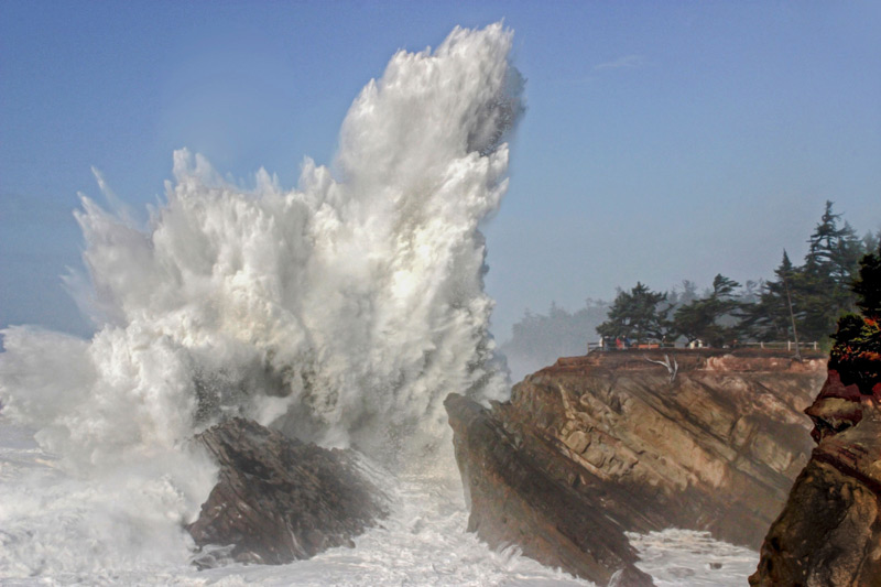
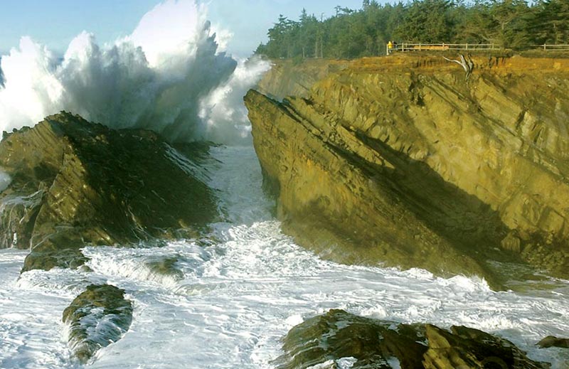
(Coos Bay, Oregon) – The mighty Pacific Ocean of the Oregon coast really lives up to that title at one spot on the south coast: Shore Acres State Park near Charleston / Coos Bay. It’s known as the number one spot for oceanic fireworks and watery pyrotechnics, with waves that explode into the air well over 100 feet. All it takes is the average heavy surf day, and maybe not necessarily one of those surf advisories from the National Weather Service. (Photo courtesy Oregon's Adventure Coast / Steven Michael Photography)
Those waves get larger than you think. Some of them tower at 200 feet, even 300 feet high in some cases.
Includes exclusive listings; some specials in winter
In Cannon Beach:
Includes rentals not listed anywhere else
In Manzanita, Wheeler, Rockaway Beach:
Some specials for winter
In Pacific City, Oceanside:
Some specials for winter
In Lincoln City:
Some specials for winter
In Depoe Bay, Gleneden Beach:
Some specials for winter
In Newport:
Look for some specials
In Waldport
Some specials for winter
In Yachats, Florence
Some specials for winter
Southern Oregon Coast Hotels / Lodgings
Reedsport to Brookings, places to stay; winter deals
What causes this? What is it that’s different about Shore Acres State Park that makes breakers go so bonkers? All this also begs the question: how do they measure these?
The explanation quickly tossed out for the big waves at Shore Acres is that it’s the tilted angle of the rock formation in front of the cliffs, and that the waves have nowhere to go than up. That’s true, but there’s more to the story than that – it’s not that simple. Some of these deeper details are known by scientists and some are still a mystery.
As two regional geologists told Oregon Coast Beach Connection, it’s a combination of what seems to be a deeper ocean depth, an incline that goes down towards the east, and the fact those waves hit a surface so suddenly. They also don’t have much time between when they’ve turned into larger waves offshore and when they smack into in an object.
Ron Metzger is a geologist and geology professor at Southwestern Oregon Community College in Coos Bay. He said the biggest difference here is the incline of the area underneath. Most other Oregon coast spots have some kind of reef or slope that forms a ramp of sorts, a ramp that gets higher as you go towards shore. Here, everything is titled at a 40-degree angle but the opposite direction.
“If it was tilting west the wave energy would come in and it would just wash up that ramp,” Metzger said. “Here, it’s the opposite of that.”
In other words, things around here – certainly the tilted rock in front of the cliff – are pointed downwards to the east. Then the wave energy does not have a chance to dissipate on an upwards incline.
Yet something about all this seems to be compressing the wave energy as well, a bit like a spouting horn (like at Yachats or Depoe Bay) squeezes the wave power into one place. Metzger admitted he didn’t really know the full physics of the waves here, nor was he certain of what exactly lay beneath the waves.
Some parts of this were also a mystery to University of Oregon geologist and senior instructor Marli Miller, who is also the author of major books like Roadside Geology of Oregon. Yet she had some interesting insights.
According to Miller and Metzger, there is a larger formation under here called a syncline – a kind of massive dip in a V shape that surrounds the headland of Shore Acres. It’s part of the faultline system, as Shore Acres is the product of a lot of folding and moving around because of the two continental plates offshore. This syncline may add to the action at Shore Acres.
More likely, it simply has to do with the depth of the ocean around Shore Acres.
“I suspect there’s deeper water closer to Shore Acres than other parts of the coast,” she said. “There’s a good chance it’s deeper because it gets down to a depth of 400 feet at a lesser distance from Shore Acres than anywhere else.”
Miller said there’s an area out at sea where everything drops to about 400 feet, in and around the two plate boundaries that meet off this part of the coast. This low depth spot is closer to Shore Acres than any other spot on the Oregon coast. In other areas such as Brookings, Yachats or Seaside, those kinds of depths are much farther out.
So part of why the waves are so big is all that space underneath, along with what seems to be a dip downwards. Miller wasn’t sure of the depth right around this Coos Bay attraction, however, but it helps explain more of the wave physics here.
She explained further:
“Waves have a short period of time where they’re deep ocean waves, and then they’re suddenly growing, and they grow to really large sizes as they get closer to the coastline,” she said. “They don’t really break early or anything like that. There’s a shorter distance over which they grow and break and I think that allows them to be bigger waves.
“I think it has something to do with the depth of the water. The shelf is narrower here, so there’s some reason to believe that.”
Miller said with a combo of elements like these, it likely wouldn’t take the waves to be very big before they become “spectacularly so.”
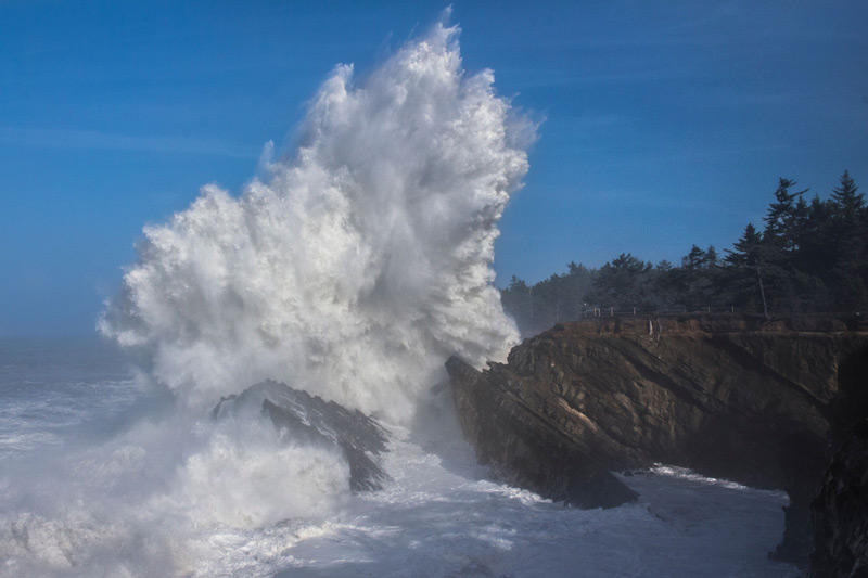
So how do these waves get measured at Shore Acres?
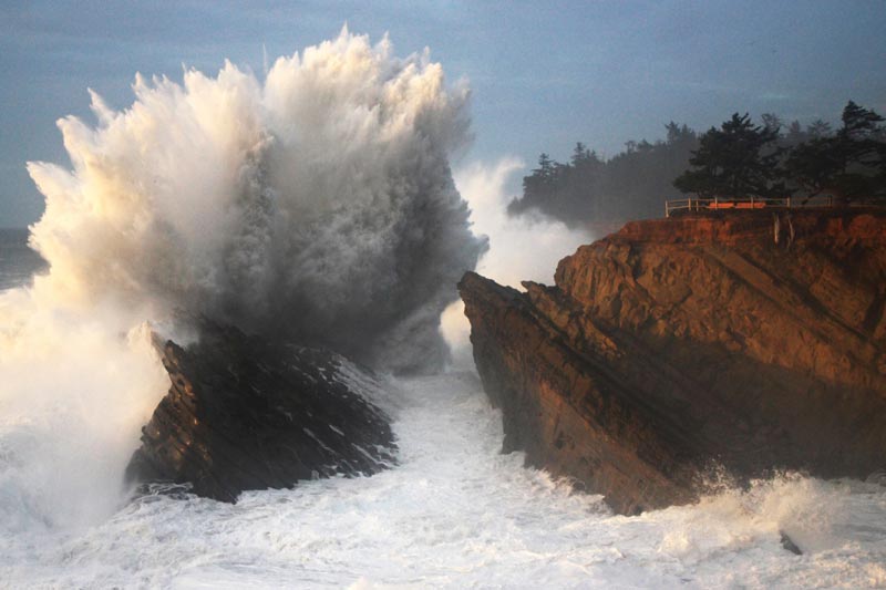
(Photo courtesy Oregon's Adventure Coast / Steven Michael Photography)
Steven Michael is a local resident who is a photographer that documents all this and he’s largely the one that’s been measuring these for years.
“A small group of us photographers came up with the process,” Michael said. “And I have just kept it going. All measurements have been based on images I have taken. Some people have sent me their images and asked to see how high it is.”
First, the measurements utilize the fact the cliff itself is about 75 feet high, but it’s still an approximation.
“The height is determined by the comparison of the cliff,” Michael said.
He then points to a sampling of his own photos and notes all this depends on the angle and where a photo was taken from. In a photo editing program, you have to separate the wave from the scene and move it around in relation to the cliff.
“If you take the cliff and stack it, you get approximately 150 feet,” he said. There are some other calculations that go into it as well.
Coos Bay, Charleston, North Bend Complete Guide: Southern Oregon Coast Travel
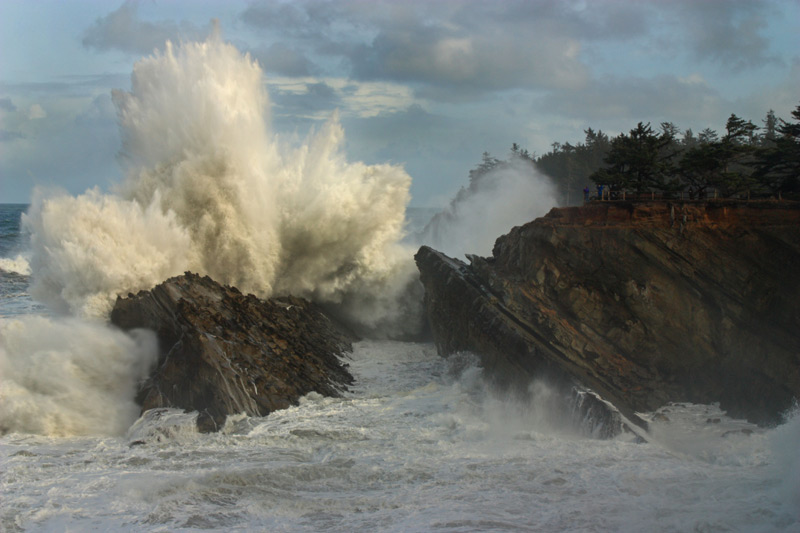
“To find out which wave is higher than another it is quite simple. We lay one photo on top the other, fade one out by 40%, line up the cliff and either increase or decrease the faded image in order to match up the point on the cliff. Then it is easy to determine which one is taller.”
Most waves seem to clock in at 100 to 150 feet. Some reach much higher though, and this past season has been pretty incredible, Michael said.
“The current record holder is from March 2016 at approximately 320 feet,” he said. MORE PHOTOS BELOW
WARNING: stay off the lower ledges of Shore Acres State Park, especially during high wave events. People have died here. The viewing area at top is outstanding and safe.
South Coast Hotels - Where to eat - Maps - Virtual Tours


Cannon Beach Lodging
Nehalem Bay Lodgings
Manzanita Hotels, Lodging
Three Capes Lodging
Pacific City Hotels, Lodging
Lincoln City Lodging
Depoe Bay Lodging
Newport Lodging
Waldport Lodging
Yachats Lodging
Oregon Coast Vacation Rentals
Oregon Coast Lodging Specials


(Photo courtesy Oregon's Adventure Coast / Steven Michael Photography. Same credit for photos below)
Also see
The Unheralded Ghost Forests of South Oregon Coast / Coos Bay in Photos The stumps at Sunset Bay at Coos Bay / Charleston are intricate, and their origin murky
More About Oregon Coast hotels, lodging.....
More About Oregon Coast Restaurants, Dining.....


LATEST Related Oregon Coast Articles
27 Jul 2026 at 8:35pm
One vehicle crossed the centerline and struck another near Seaside. Rescue, Cannon Beach, Astoria
Group of Five Rescued from Oregon Coast Surf After Repeated Warnings by Lifeg...
27 Jul 2026 at 8:35pm
As they were about to make their fourth warning, Cannon Beach lifeguards had to go into action. Seaside, Astoria, Manzanita
U.S. Astronaut from International Space Station Returns to Earth Along with T...
27 Jul 2026 at 8:35pm
Chris Williams from Maryland is back on Earth. Astronomy, Portland
Oregon Air Quality - Current Air Quality, Forecast
27 Jul 2026 at 8:35pm
See air quality issues throughout Oregon: forecasts, particle pollution issues, ozone measurements, smoke / haze. Weather. Portland, Madras, Bend, Salem, Eugene, Pendleton, The Dalles, Medford, Klamath Falls
Two Meteor Showers Now, Lunar Eclipse Coming: U.S., West Coast, Oregon / Wash...
27 Jul 2026 at 8:35pm
Delta Aquariids and Perseids now; eclipse later in August. Amazing fireballs now. Weather, astronomy, events
14 More Central Oregon Coast Firefighters Head East to Battle Blazes
26 Jul 2026 at 8:27am
Equipment and personnel from Lincoln City, Newport, Oceanside fighting the Akawa Butte. Rescue. weather
Today a Landmark Day for Oregon Coast's Yaquina Head Lighthouse - Newport His...
26 Jul 2026 at 8:28am
On this day in 1873 a telegram changed history
Sizzle on Central Oregon Coast with Grammy-nominated Guitarist Diego Figueiredo
26 Jul 2026 at 8:29am
Aug 1 and 2 in Newport at the NPAC. Newport events
Back to Oregon Coast
Contact Advertise on BeachConnection.net
All Content, unless otherwise attributed, copyright BeachConnection.net Unauthorized use or publication is not permitted

Oregon
Coast Hotels
Seaside Hotels
Cannon
Beach Hotels
Nehalem Bay Lodgings
Manzanita Hotels, Lodging
Rockaway Beach Hotels
Three Capes Lodging
Pacific City Hotels, Lodging
Lincoln
City Lodging
Depoe
Bay Hotels
Newport Hotels
Waldport Lodging
Yachats
Lodging
Oregon
Coast Vacation Rentals
Oregon
Coast Lodging Specials
South Coast Hotels
Dining
Guide
Seaside
Cannon
Beach Dining
Manzanita,
Rockaway, Wheeler Dining
Pacific
City, Oceanside, Netarts, Tierra Del Mar Restaurants
Tillamook
Bay Restaurants, Dining
Lincoln
City Dining, Restaurants
Depoe
Bay Restaurants, Dining
Newport Restaurants, Dining
Waldport,
Yachats Restaurants, Dining
Florence Restaurants, Dining
Restaurant
Reviews
Coast
Events Calendar
Astoria
Seaside,
Cannon Beach Calendar
Manzanita,
Rockaway Events
Tillamook,
Pacific City Calendar
Lincoln
City Events Calendar
Newport,
Depoe Bay Events Calendar
Yachats Events Calendar
Oregon Coast Complete Guides every beach access, attraction
Search for Oregon Coast Subjects, Articles
Explore Every Beach Spot


News Headlines from All Over Oregon Need to scan Oregon headlines? Constantly updated news from all over Oregon: a comprehensive, up-to-the-minute display of news headlines from a variety of media
Oregon Coast Oceanfront Lodging, Hotels, Rentals
Book Coastal Lodging Now
Booking.com