Updated Monthly
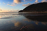
Complete Guide to Cannon Beach, on the Oregon
Coast - Every Beach Access
 (Cannon
Beach, Oregon) - It's home to many artists on the coast, and a few national
celebrities have cabins nearby as well. It's an arty vibe that shows,
partially in the city council’s rule that most buildings be dressed
up in cedar shingles, giving the whole town a sense of the rustic yet
refined. (Cannon
Beach, Oregon) - It's home to many artists on the coast, and a few national
celebrities have cabins nearby as well. It's an arty vibe that shows,
partially in the city council’s rule that most buildings be dressed
up in cedar shingles, giving the whole town a sense of the rustic yet
refined.
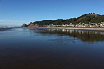
This artiness is also apparent in the abundance of quaint
businesses around Cannon Beach, from whimsical shops selling kites, clothes
and gifts, to its galleries, fine cuisine in a variety of price ranges
and the many flowerpots hanging everywhere. Some of the restaurants and
bars even have outdoor seating – a daring, if not very urban-thinking
move on the coast.

THIS PAGE IS UNDERGOING RECONSTRUCTION
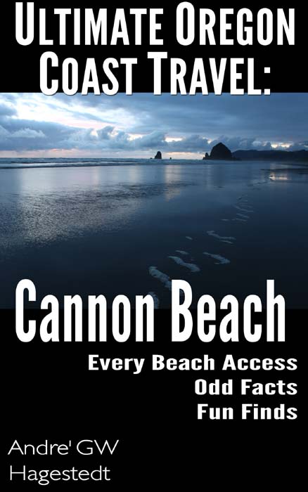
in the meantime, there is this complete guide to all things Cannon Beach available as an ebook and paperback from Amazon: Ultimate Oregon Coast Travel: Cannon Beach - Odd Facts, Fun Finds, Every Access.
A deeply detailed guide to Cannon Beach. Every beach access in the area, wild nature facts, history, geology, funky beach finds. Find oddities such as glowing sand, green flash at sunset, the surreal Red Towers, singing sands, and more. Full of photos and walk-throughs of each area. Perfect guide for those who are new to the area or for those looking for a deeper, more intense coastal experience. Comes with a Quick Guide to all beaches, then the mind-bending array of details. Purchase here for $4.99 - $12.99 for paperback.
The first in the Ultimate Oregon Coast Travel series.
Now Also Available: Lincoln City and Seaside books.
Cannon Beach, Oregon Lodging, Hotels, Motels, Restaurants, Inns, Vacation Rentals
Beachcomber Vacation Homes, Cannon Beach Rentals
Numerous vacation homes in the Cannon Beach area, including Arch Cape and Falcon Cove. Cannon Beach lodgings, kids
Schooner's Cove Inn
Oceanfront upscale w/ picnic lawn, decks, spa
The Wayside Inn
Ocean view rooms, pet friendly, S. end of Cannon Beach
Tolovana Inn
Views of Haystack; classic luxury with saltwater pool, spa, spacious rooms
Fultano's Pizza Cannon Beach
Gourmet Italian and a Family Price; deliveries, order online
MacGregor's Whiskey Bar, Cannon Beach
Exceptional cuisine in an upscale, innovative whiskey bar
Dining, Restaurants, Menus in Cannon Beach, Oregon.
Eateries in Cannon Beach
ATTRACTION: Seaside Aquarium
More than 70 years of letting you feed the seals
Near Cannon Beach: Seashore Inn, Seaside Hotel
Oceanfront, pet friendly, heated indoor pool, steps from beach attractions
Vacation Rentals in Astoria, Warrenton, Gearhart
Near Cannon Beach: Multi-bedroom houses, north Oregon coast luxury lodging to budget, including Seaside
|
Two-Car Collision Saturday on N. Oregon Coast Results in Serious Injuries, Li...
27 Jul 2026 at 8:35pm
One vehicle crossed the centerline and struck another near Seaside. Rescue, Cannon Beach, Astoria
Group of Five Rescued from Oregon Coast Surf After Repeated Warnings by Lifeg...
27 Jul 2026 at 8:35pm
As they were about to make their fourth warning, Cannon Beach lifeguards had to go into action. Seaside, Astoria, Manzanita
Missing Hiker and Second Missing Person Found in Two North Oregon Coast Rescues
23 Jul 2026 at 7:48pm
On Tillamook Head and Gnat Creek area. Seaside, Cannon Beach, Astoria
Seaside Beach Discovery Hits These North Oregon Coast Sands for Summer
10 Jul 2026 at 7:56pm
July and August on the beach, imparting awe. Seaside events, Gearhart events, Astoria, Cannon Beach
Prolific Clamming Area on N. Oregon Coast Closes Soon for Annual Conservation
9 Jul 2026 at 5:34pm
Starts in Seaside / Warrenton July 15 and continues through October 1. Cannon Beach, Manzanita, Gearhart, Astoria
N. Oregon Coast Emergencies: Cannon Beach FD Deals with Injured Hiker, Missin...
7 Jul 2026 at 7:59pm
Crashes, missing child, hiker at Ecola, Life Flight and traffic hazard. Rescue, Seaside, Arch Cape, Silver Point
Cannon Beach, Oregon Coast Virtual Tour - Maps, All Beaches, Attractions, Tr...
3 Jul 2026 at 2:36am
Every beach access, travel updates, mileposts, 100s of photos. Sciences, weather
Now Through July 4: Great Cannon Beach Puffin Watch on N. Oregon Coast
2 Jul 2026 at 6:43am
Offering morning viewing opportunities from 8 to 11 a.m. in front of Haystack Rock. Cannon Beach events
Oregon Officials Advice on Fireworks, Leave Them At Home If Heading to State ...
27 Jun 2026 at 11:23pm
Fireworks are banned in all state parks; Sheriffs urge caution. Safety. Astoria events, Seaside events, Cannon Beach events, Manzanita events, Rockaway Beach events, Tillamook events, Oceanside events, Pacific City events, Lincoln City events, Depoe Bay events, Newport events, Waldport events, Yachats events, Florence events, Reedsport events, North Bend events, Coos Bay events, Charleston events, Bandon events, Port Orford events, Gold Beach events, Brookings events. Weather
|
For
more details on Cannon Beach and tons of pictures, see the Cannon Beach
Virtual Tour, Map.
For tons of Cannon
Beach Lodging, click here.
|
|
|
Search
for Oregon Coast Subjects, Articles
Oregon
Coast Camping
|
OREGON
COAST VIRTUAL TOUR
Explore Every Beach Spot in Hundreds of
Oregon Coast Pictures |

Astoria
Where the Columbia meets the Pacific, Land of Lewis &
Clark and loads of atmosphere & history |

Seaside
The Promenade, Tillamook Head, family fun & broad, sandy
beaches |

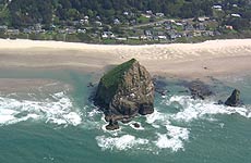
Cannon
Beach
A mysterious lighthouse, upscale yet earthy, a huge monolith,
fine eateries & an art mecca |
|

Tillamook Bay
Garibaldi, Barview, Bay City, Tillamook & an oceanfront
ghost town |
|
|

Depoe Bay
A spouting horn downtown, freaky hidden cliffs and whales,
whales, whales |

Newport
Time-tripping Nye Beach, a bustling bayfront, marine science-central
and two lighthouses |
|

Yachats
Constantly dramatic wave action, a mix of the rugged &
upscale |
|

Florence
A lighthouse, ancient bayfront and miles and miles of fluffy
dunes |
|


Oregon Coast Highway, Coast Range Passes Traffic, Road Conditions
For more about Cannon Beach....
CONTACT
/ ADVERTISE ON BEACH CONNECTION |