


Oregon, Coast Earthquake Updates - Live Data Oregon, Washington, California, Tsunamis
Live Earthquake Updates from Oregon, Washington. B.C., California, Alaska - Live Eartquake Data for West Coast: Oregon, Oregon coast, Washington, California, British Columbia
Return to this page periodically and see the information below to keep up on earthquake activity around the West Coast of the United States, streamed from the USGS, along with article posts from that agency and Pacific Northwest Seismic Network.
USGS All Earthquakes, Past Day
M 1.6 - 13 km NNE of Houston, Alaska
M 1.6 - 63 km NW of Tatitlek, Alaska
M 1.3 - 34 km S of Manley Hot Springs, Alaska
M 1.4 - 51 km WNW of Happy Valley, Alaska
M 1.1 - 87 km NW of Karluk, Alaska
M 4.0 - 112 km SSW of Nikolski, Alaska ShakeMap - II
M 0.7 - 35 km ESE of Nenana, Alaska
M 2.1 - 62 km ESE of Pedro Bay, Alaska
M 0.9 - 16 km W of Four Mile Road, Alaska
M 2.6 - 86 km ESE of Red Dog Mine, Alaska
M 3.7 - 103 km SSW of Nikolski, Alaska ShakeMap - I
M 0.7 - 7 km NW of Belfair, Washington
M 1.9 - 17 km W of Four Mile Road, Alaska
M 1.5 - 17 km W of Four Mile Road, Alaska
M 1.2 - 16 km W of Four Mile Road, Alaska
M 1.7 - 16 km W of Four Mile Road, Alaska
M 1.5 - 16 km W of Four Mile Road, Alaska
M 1.8 - 35 km W of Clear, Alaska
M 1.1 - 44 km SW of Beaver, Alaska
M 2.0 - 15 km W of Four Mile Road, Alaska DYFI? - II
M 1.5 - 20 km NW of Tatitlek, Alaska
M 2.3 - 44 km SE of Perryville, Alaska
M 1.6 - 10 km NW of Four Mile Road, Alaska
M 1.6 - 40 km N of Valdez, Alaska
M 1.6 - 17 km W of Four Mile Road, Alaska
M 1.9 - 88 km NNW of Aleneva, Alaska
M 1.8 - 24 km NNE of Willow, Alaska
M 1.7 - 56 km NNE of Petersville, Alaska
3 May 2024 at 12:39am
Time2024-05-03 00:37:50 UTC2024-05-03 00:37:50 UTC at epicenterLocation62.982°N 150.437°WDepth66.90 km (41.57 mi)
3 May 2024 at 12:35am
Time2024-05-03 00:33:34 UTC2024-05-03 00:33:34 UTC at epicenterLocation61.748°N 149.740°WDepth34.80 km (21.62 mi)
2 May 2024 at 11:41pm
Time2024-05-02 23:40:16 UTC2024-05-02 23:40:16 UTC at epicenterLocation61.223°N 147.586°WDepth4.80 km (2.98 mi)
2 May 2024 at 11:19pm
Time2024-05-02 23:17:39 UTC2024-05-02 23:17:39 UTC at epicenterLocation64.696°N 150.574°WDepth9.00 km (5.59 mi)
2 May 2024 at 9:37pm
Time2024-05-02 21:35:51 UTC2024-05-02 21:35:51 UTC at epicenterLocation60.130°N 152.577°WDepth85.00 km (52.82 mi)
2 May 2024 at 9:26pm
Time2024-05-02 21:23:33 UTC2024-05-02 21:23:33 UTC at epicenterLocation58.177°N 155.380°WDepth0.00 km (0.00 mi)
2 May 2024 at 9:29pm
2 May 2024 at 7:11pm
Time2024-05-02 19:10:02 UTC2024-05-02 19:10:02 UTC at epicenterLocation64.472°N 148.390°WDepth14.50 km (9.01 mi)
2 May 2024 at 6:05pm
Time2024-05-02 18:02:18 UTC2024-05-02 18:02:18 UTC at epicenterLocation59.582°N 153.083°WDepth113.90 km (70.77 mi)
2 May 2024 at 5:54pm
Time2024-05-02 17:52:52 UTC2024-05-02 17:52:52 UTC at epicenterLocation64.620°N 149.459°WDepth19.10 km (11.87 mi)
2 May 2024 at 5:35pm
Time2024-05-02 17:20:42 UTC2024-05-02 17:20:42 UTC at epicenterLocation67.883°N 160.865°WDepth21.30 km (13.24 mi)
2 May 2024 at 8:27pm
2 May 2024 at 4:33pm
Time2024-05-02 16:14:38 UTC2024-05-02 16:14:38 UTC at epicenterLocation47.500°N 122.891°WDepth13.84 km (8.60 mi)
2 May 2024 at 4:03pm
Time2024-05-02 16:02:08 UTC2024-05-02 16:02:08 UTC at epicenterLocation64.581°N 149.488°WDepth10.00 km (6.21 mi)
2 May 2024 at 3:52pm
Time2024-05-02 15:50:29 UTC2024-05-02 15:50:29 UTC at epicenterLocation64.588°N 149.481°WDepth1.00 km (0.62 mi)
2 May 2024 at 3:43pm
Time2024-05-02 15:41:49 UTC2024-05-02 15:41:49 UTC at epicenterLocation64.625°N 149.460°WDepth19.90 km (12.37 mi)
2 May 2024 at 3:41pm
Time2024-05-02 15:39:35 UTC2024-05-02 15:39:35 UTC at epicenterLocation64.612°N 149.461°WDepth16.50 km (10.25 mi)
2 May 2024 at 3:36pm
Time2024-05-02 15:34:16 UTC2024-05-02 15:34:16 UTC at epicenterLocation64.598°N 149.460°WDepth0.00 km (0.00 mi)
2 May 2024 at 2:56pm
Time2024-05-02 14:54:21 UTC2024-05-02 14:54:21 UTC at epicenterLocation64.268°N 149.920°WDepth5.20 km (3.23 mi)
2 May 2024 at 2:34pm
Time2024-05-02 14:31:17 UTC2024-05-02 14:31:17 UTC at epicenterLocation66.077°N 148.109°WDepth14.20 km (8.82 mi)
2 May 2024 at 2:28pm
2 May 2024 at 1:43pm
Time2024-05-02 13:41:29 UTC2024-05-02 13:41:29 UTC at epicenterLocation60.982°N 146.972°WDepth21.10 km (13.11 mi)
2 May 2024 at 12:59pm
Time2024-05-02 12:56:50 UTC2024-05-02 12:56:50 UTC at epicenterLocation55.602°N 158.697°WDepth30.30 km (18.83 mi)
2 May 2024 at 12:56pm
Time2024-05-02 12:54:15 UTC2024-05-02 12:54:15 UTC at epicenterLocation64.675°N 149.276°WDepth11.20 km (6.96 mi)
2 May 2024 at 12:55pm
Time2024-05-02 12:53:53 UTC2024-05-02 12:53:53 UTC at epicenterLocation61.497°N 146.361°WDepth28.20 km (17.52 mi)
2 May 2024 at 12:52pm
Time2024-05-02 12:50:24 UTC2024-05-02 12:50:24 UTC at epicenterLocation64.603°N 149.477°WDepth0.70 km (0.43 mi)
2 May 2024 at 12:41pm
Time2024-05-02 12:39:50 UTC2024-05-02 12:39:50 UTC at epicenterLocation58.820°N 153.362°WDepth19.10 km (11.87 mi)
2 May 2024 at 12:21pm
Time2024-05-02 12:19:13 UTC2024-05-02 12:19:13 UTC at epicenterLocation61.941°N 149.823°WDepth27.00 km (16.78 mi)
Seismo Blog Posts Feed
The MyShake app is now delivering ShakeAlert-powered alerts in Washington
26 Jan 2022 at 9:43am
Good news for people who have been waiting for a ShakeAlert app to come to their smartphones: As of today, the 322nd anniversary of the last Cascadia Big One, the MyShake app is now available in Washington state.
Blanco Fracture Zone swarm: Active, unusual, interesting... but not concerning
10 Dec 2021 at 12:53am
On Tuesday morning about 300 miles off the coast of Oregon, an intense swarm of moderate sized earthquakes began on the Blanco Fracture Zone. This is active, unusual, and interesting, but not concerning. We take a deep dive in this blog post.
Washington?s Unsafe Schools
20 Sep 2021 at 8:34pm
A recent DNR report showed that many of Washington's schools are extremely vulnerable to earthquakes. Former State Representative Jim Buck argues that the state should be doing more to solve the problem.
ShakeAlert Warning Times for earthquakes in the Pacific Northwest
28 Jul 2021 at 4:12pm
If an earthquake were to occur tomorrow somewhere in Washington or Oregon, how much warning time would you expect to get from ShakeAlert?
-- LATEST QUAKE, VOLCANIC, GEOLOGIC NEWS from OREGON / WASHINGTON COAST --
March 11 of 2011 and March 27 of 1964. Sciences, geology. Bandon, Port Orford
Why Those Quake Swarms Off Oregon Coast? Geologists Provide Answers
Why some were so close to Bandon, how it's affecting Cape Blanco. Geology, sciences
Swarm of Ten Quakes Off S. Oregon Coast, 7 Within Minutes - UPDATE
It started Monday and lasted through Wed morning near Bandon, Port Orford. Marine sciences, geology
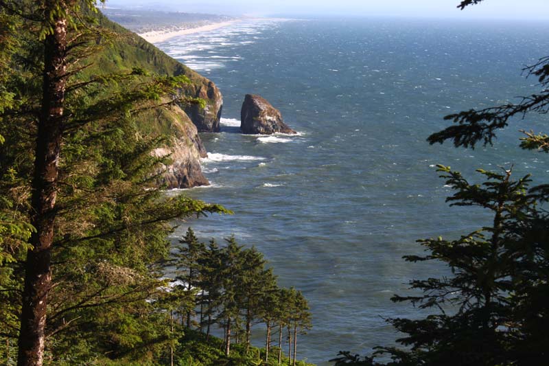
The 'Orphan' of Neskowin on N. Oregon Coast
Underneath that looming presence of Cascade Head an ancient geology tale
Four Unique to Bizarre Aspects of One Chunk of Oregon Coast: Between Yachats ...
Weird steps, wondrous pathway, volcanic remnants. Geology
N. Oregon Coast's Hug Point Has Its Ancient, Millions-of-Years-Old Secrets
Just a few short miles of Cannon Beach you'll bump into Hug Point. Geology, marine sciences, history
Heceta Head Lighthouse Florence, Oregon Coast Virtual Tour
Glimpse history of the lighthouse, its geology and other fun facts
Beloved Beach Arch in Newport Crumbles, Leaving Oregon Coast With Bit of Geol...
It survived millions of years, but there's a geology puzzle here. Sciences
Three Curiosities of Seaside's The Cove - North Oregon Coast Oddities
From morbid to delightful; geology, history, surprises
Small Quakes This Week Off Oregon Coast; Prineville and Welches Possible Volc...
Magnitude 3.8 off Brookings. Oregon coast news: Curry County news. Geology


ALSO SEE OREGON COAST GEOLOGY
ALSO SEE OREGON COAST HOTELS
Search over 7,5000 Pages for Oregon coast subjects, articles or lodging...
Back to Oregon Coast
Contact Advertise on BeachConnection.net
All Content, unless otherwise attributed, copyright BeachConnection.net Unauthorized use or publication is not permitted
Follow us on


South Coast Hotels
Oregon
Coast Hotels
Seaside
Cannon
Beach Lodging
Nehalem Bay Lodgings
Manzanita Hotels, Lodging
Rockaway Beach Hotels
Three Capes Lodging
Pacific City Hotels, Lodging
Lincoln
City Lodging
Depoe
Bay Lodging
Newport Lodging
Waldport Lodging
Yachats
Lodging
Oregon
Coast Vacation Rentals
Oregon
Coast Lodging Specials
Oregon Coast Luxury Hotels
Oregon Coast Pet Friendly Hotels/Rentals
Oregon
Coast Bed and Breakfasts / B&Bs
Cannon Beach Vacation Rentals
Pacific City Vacation Rentals
Newport, Depoe Bay Vacation Rentals
Oregon Coast Restaurant, Dining
Guide
Seaside
Cannon
Beach Dining
Manzanita,
Rockaway, Wheeler Dining
Pacific
City, Oceanside, Netarts, Tierra Del Mar Restaurants
Tillamook
Bay Restaurants, Dining
Lincoln
City Dining, Restaurants
Depoe
Bay Restaurants, Dining
Newport Restaurants, Dining
Waldport,
Yachats Restaurants, Dining
Florence Restaurants, Dining
Restaurant
Reviews
Coast
Events Calendar
Astoria
Seaside,
Cannon Beach Calendar
Manzanita,
Rockaway Events
Tillamook,
Pacific City Calendar
Lincoln
City Events Calendar
Newport,
Depoe Bay Events Calendar
Yachats Events Calendar
Oregon Coast Weather
Seaside Weather
Cannon Beach
Manzanita
Nehalem Bay / Wheeler
Rockaway
Oceanside/Tillamook
Pacific City
Lincoln City
Depoe Bay Weather
Newport
Yachats
Florence
Search for Oregon Coast Subjects, Articles
Explore Every Beach Spot

Astoria
Where the Columbia meets the Pacific, Land of Lewis & Clark and loads of atmosphere & history

Seaside
The Promenade, Tillamook Head, family fun & broad, sandy beaches

Cannon Beach
A mysterious lighthouse, upscale yet earthy, a huge monolith, fine eateries & an art mecca

Nehalem Bay - Manzanita, Rockaway, Wheeler
Manzanita's beaches, Nehalem and Wheeler's quirky beauty; laid back Rockaway

Tillamook Bay
Garibaldi, Barview, Bay City, Tillamook & an oceanfront ghost town

Three Cape Loop - Oceanside, Netarts, Pacific City
The hidden secret of the coast: Cape Meares, a lighthouse, Oceanside, Netarts and Pacific City

Lincoln City & the Corridor of Mystery
Miles & miles of unbroken beaches, Cascade Head, Neskowin and manmade attractions

Depoe Bay
A spouting horn downtown, freaky hidden cliffs and whales, whales, whales

Newport
Two lighthouses, timeless Nye Beach, bustling bayfront, regal bridge

Waldport, Seal Rock
Sands and dunes, craggy Seal Rock, semi-secret beaches

Yachats
Constantly dramatic wave action, a mix of the rugged & upscale

Upper Lane County
25 miles of deserted beaches & oodles of wonders

Florence
A lighthouse, ancient bayfront and miles and miles of fluffy dunes
South Oregon Coast Travel
News Headlines from All Over Oregon Need to scan Oregon headlines? Constantly updated news from all over Oregon: a comprehensive, up-to-the-minute display of news headlines from a variety of media
Oregon Coast Oceanfront Lodging, Hotels, Rentals