N. Oregon Coast's Tillamook County Now Has 3-D, Interactive Recreation Map
Published 06/17/21 at 4:10 PM PDT
By Oregon Coast Beach Connection staff
(Tillamook, Oregon) – Now you can literally have one part of the Oregon coast at your fingertips.
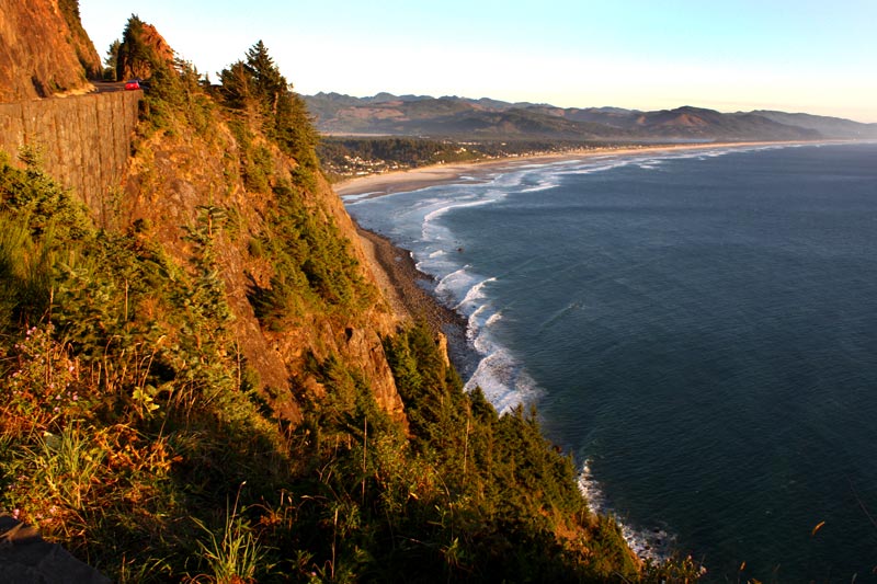
The north Oregon coast's Tillamook Coast Visitors Association (TCVA) has just released an online GIS-enabled map that details Tillamook County's trails and outdoor recreation areas. This area covers the towns of Neskowin, Pacific City, Tierra Del Mar, Oceanside, Netarts, Cape Meares, Tillamook, Bay City, Hebo, Garibaldi, Brighton, Rockaway Beach, Wheeler, Nehalem and Manzanita – as well as all the areas in between.
Includes exclusive listings; some specials in winter
In Cannon Beach:
Includes rentals not listed anywhere else
In Manzanita, Wheeler, Rockaway Beach:
Some specials for winter
In Pacific City, Oceanside:
Some specials for winter
In Lincoln City:
Some specials for winter
In Depoe Bay, Gleneden Beach:
Some specials for winter
In Newport:
Look for some specials
In Waldport
Some specials for winter
In Yachats, Florence
Some specials for winter
Southern Oregon Coast Hotels / Lodgings
Reedsport to Brookings, places to stay; winter deals
Tillamook County offers a bounty of outdoor recreation – fishing, hiking, kayaking, camping, surfing, birdwatching, horseback riding, mountain biking, even just hanging out on the beach. Now, with a new online GIS trails and recreation map, it's easy to plan a trip, do the things you love, and discover new places to do them.
“This recreation map is a ‘live map,' one we'll be updating with new features and data,” said Nan Devlin, executive director of TCVA, otherwise known as Visit Tillamook Coast. “We will also regularly gather information from our land managers and first responders throughout the county to keep the public informed of events, such as fires, trail changes or closures, King Tides and floods.”
The GIS map is at https://tillamookcoast.com/recreation-map and includes downloadable area maps if a person will be in an area without cell service. The GIS map lists more than 800 locations in 13 categories: campgrounds, parks and day use areas, trailheads, boat launches, beach and water access, dispersed campsites, equestrian trails, mountain bike trails, hiking trails, community trails, the Oregon Coast Trail, water trails, and other recreation.
“This recreation map is a ‘live map,' one we'll be updating with new features and data,” said Nan Devlin, executive director of Tillamook Coast Visitors Association. “We will also regularly gather information from our land managers and first responders throughout the county to keep the public informed of events, such as fires, trail changes or closures, King Tides and floods.”
The GIS project is a collaborative effort of Tillamook County Wellness, Mt. Hebo Ranger Station, Tillamook County, Tillamook Coast Visitors Association, and New Youth Corps, which oversaw the intern, Samantha Goodwin, who gathered the database. Cardwell Creative of Salem transformed the data into a user-friendly website page.
Just click on an area of the map and a pop-up window provides information about each recreation site. Additional features will be added in the next few months, and there is a form on the website where recreation users can provide information. There are also links to public transportation, beach wheelchair reservations, and a page about prime birdwatching areas.
For more trip planning ideas, order or download a visitor guide at https://tillamookcoast.com/gettheguide. To learn about destination management – and to take our Tillamook Coast Pledge – go to https://tillamookcoast.com/caring-for-our-coast
MORE PHOTOS BELOW

Hotels in Rockaway Beach - Where to eat - Rockaway Beach Maps and Virtual Tours


Cannon Beach Lodging
Nehalem Bay Lodgings
Manzanita Hotels, Lodging
Three Capes Lodging
Pacific City Hotels, Lodging
Lincoln City Lodging
Depoe Bay Lodging
Newport Lodging
Waldport Lodging
Yachats Lodging
Oregon Coast Vacation Rentals
Oregon Coast Lodging Specials


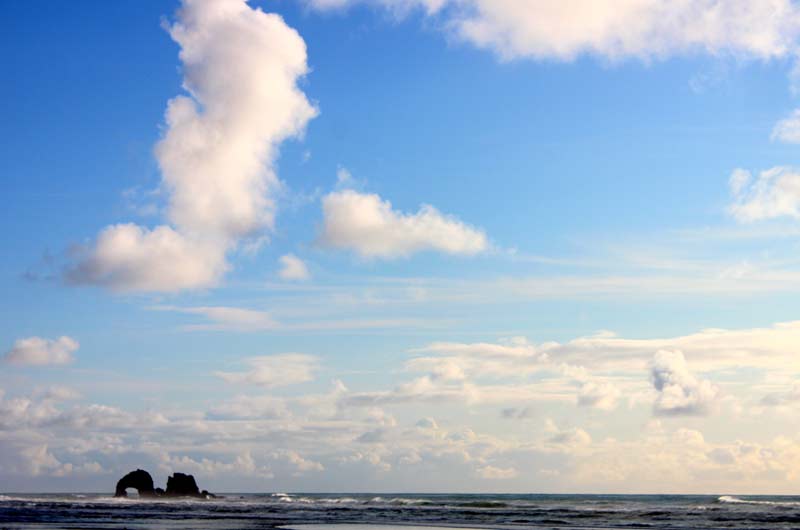
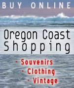
Photo courtesy Pilar French
More About Oregon Coast hotels, lodging.....
More About Oregon Coast Restaurants, Dining.....


LATEST Related Oregon Coast Articles
27 Jun 2026 at 11:23pm
The man was taken to a burn center in Portland. Video of lightning by satellite. Molalla, Clackamas County, Marion County, Wilsonville
Oregon Coast Jazz Party Announces Lineup in Newport - October
27 Jun 2026 at 11:23pm
October 2 - 4 in Nye Beach, Newport. Newport events
Oregon Officials Advice on Fireworks, Leave Them At Home If Heading to State ...
27 Jun 2026 at 11:23pm
Fireworks are banned in all state parks; Sheriffs urge caution. Safety. Astoria events, Seaside events, Cannon Beach events, Manzanita events, Rockaway Beach events, Tillamook events, Oceanside events, Pacific City events, Lincoln City events, Depoe Bay events, Newport events, Waldport events, Yachats events, Florence events, Reedsport events, North Bend events, Coos Bay events, Charleston events, Bandon events, Port Orford events, Gold Beach events, Brookings events. Weather
Absolute Complete Guide to Oregon Coast Fourth of July, 2026: All Towns
26 Jun 2026 at 6:51am
Astoria events, Seaside events, Cannon Beach events, Manzanita events, Rockaway Beach events, Tillamook events, Oceanside events, Pacific City events, Lincoln City events, Depoe Bay events, Newport events, Waldport events, Yachats events, Florence events, Reedsport events, North Bend events, Coos Bay events, Charleston events, Bandon events, Port Orford events, Gold Beach events, Brookings events. Weather
Pirate Invasion, Curry County Fair and Wild Mushrooms Dot S. Oregon Coast Lan...
26 Jun 2026 at 6:51am
Fair in Gold Beach July 23 - 26; Pirates of Pacific Fest Aug 7 - 9; Wild Rivers Mushroom Fest Nov 7 - 8. Brookings events, Gold Beach events
Manzanita in July: History of Oregon Coast's 101 and Pirate-Themed Scavenger ...
26 Jun 2026 at 6:51am
July 9: Scavenger Hunt. July 11: History of Highway. Manzanita events, Nehalem events, Cannon Beach events, Tillamook events
Oregon Coast News Roundup: Dead Whale, Fatal Vehicle Wreck, Arrests
26 Jun 2026 at 6:51am
19th deceased whale this year; fatal collision Yamhill County. Seaside, marine sciences, Gearhart, Newberg, traffic, true crime
Famous Orcas from Alaskan Rescue Effort Pop Up on Oregon Coast, Blowing Up So...
26 Jun 2026 at 6:51am
The pair were stuck in a lake in 2023 and freed by elaborate means. Marine sciences, Newport
Back to Oregon Coast
Contact Advertise on BeachConnection.net
All Content, unless otherwise attributed, copyright BeachConnection.net Unauthorized use or publication is not permitted

Oregon
Coast Hotels
S. Coast Hotels
Seaside Hotels
Cannon
Beach Hotels
Nehalem Bay Lodgings
Manzanita Hotels, Lodging
Rockaway Beach Hotels
Three Capes Lodging
Pacific City Hotels, Lodging
Lincoln
City Lodging
Depoe
Bay Hotels
Newport Hotels
Waldport Lodging
Yachats
Lodging
Oregon
Coast Vacation Rentals
Oregon
Coast Lodging Specials
South Coast Hotels
Dining
Guide
Seaside
Cannon
Beach Dining
Manzanita,
Rockaway, Wheeler Dining
Pacific
City, Oceanside, Netarts, Tierra Del Mar Restaurants
Tillamook
Bay Restaurants, Dining
Lincoln
City Dining, Restaurants
Depoe
Bay Restaurants, Dining
Newport Restaurants, Dining
Waldport,
Yachats Restaurants, Dining
Florence Restaurants, Dining
Restaurant
Reviews
Coast
Events Calendar
Astoria
Seaside,
Cannon Beach Calendar
Manzanita,
Rockaway Events
Tillamook,
Pacific City Calendar
Lincoln
City Events Calendar
Newport,
Depoe Bay Events Calendar
Yachats Events Calendar
Oregon Coast Complete Guides every beach access, attraction
Search for Oregon Coast Subjects, Articles
Explore Every Beach Spot


News Headlines from All Over Oregon Need to scan Oregon headlines? Constantly updated news from all over Oregon: a comprehensive, up-to-the-minute display of news headlines from a variety of media
Oregon Coast Oceanfront Lodging, Hotels, Rentals
Book Coastal Lodging Now
Booking.com