The Decade the Oregon Coast Burned - 1930s
Published 01/04/22 at 6:52 AM PST
By Oregon Coast Beach Connection staff
Includes exclusive listings; some specials in winter
In Cannon Beach:
Includes rentals not listed anywhere else
In Manzanita, Wheeler, Rockaway Beach:
Some specials for winter
In Pacific City, Oceanside:
Some specials for winter
In Lincoln City:
Some specials for winter
In Depoe Bay, Gleneden Beach:
Some specials for winter
In Newport:
Look for some specials
In Waldport
Some specials for winter
In Yachats, Florence
Some specials for winter
Southern Oregon Coast Hotels / Lodgings
Reedsport to Brookings, places to stay; winter deals
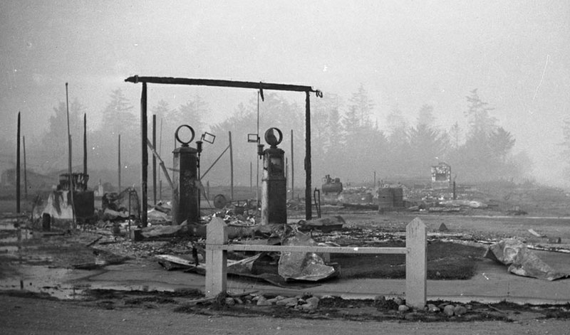
(Oregon Coast) - 1936 was an insanely unlucky year for the Oregon coast, with two major fires of an historical nature happening that year and some 25 different fires hitting other places like Coos Bay or Waldport. A few years prior and after saw other massive forest fires – actually from the same place. (Above: the Bandon Fire in 1936, courtesy State of Oregon)
The ‘30s were simply not a good decade for the coastline in some ways. Some aspects would prove deadly.
Tillamook Burn
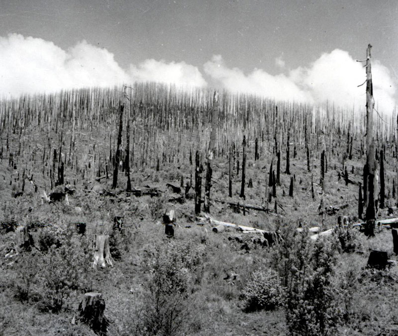
Tillamook Burn in the '40s
These days, some 70 years after the last flame, there's little to no evidence of the Great Tillamook Burn that took away much of the forestland of the Oregon Coast Range. It was unique in history as being one that lasted on and off for two decades. The Tillamook Burn started in 1933 and continued into 1951, returning some three times and occasionally burning the same area over again, destroying over 500 square miles of Coast Range.
On a hot August day in 1933, a logging operation on the north fork of Gales Creek accidentally ignited the first spark, and within an hour this forest fire seared as much as sixty acres. History generally records it as started by one log causing friction against another as it was dragged across it. Despite the best efforts of loggers working the area at the time, the fire continued to spread, and by nightfall it had overwhelmed the men – who were not trained firefighters in the first place. Being in a far flung part of the Oregon Coast Range, at a time when the major highways to the beaches didn't exist, access for actual firefighters was nearly nil. It raged on for ten days.
In the end, the first round consumed some 60 square miles of forestland, finally stopped in its tracks by September rain. The second took place in ‘39 and took out 190,000 acres; the third happened in ‘45 and the last one in 1951. Sometimes, other burned spots saw the trees that were left either standing or on the ground dry up and reignite. The second and third fires included much land that had already been singed out of usefulness.
In each case, the remote locations of the infernos left Oregon fire officials unable to respond, and some re-eruptions came close to the devastation of the first one.
All these lands at the time were privately owned, and with every new burn more companies lost their ownership to local counties. By the mid ‘50s, these were turned over to the state, which helped create entirely new forest management policies, preventing many – but not all – future burns.
The entire disaster helped inspire an epic reclamation effort, with hundreds of people planting more seeds until 1972, into the area known for much of that time as The Burn. Only in recent decades has that moniker been shaken loose.
The Bandon Fire
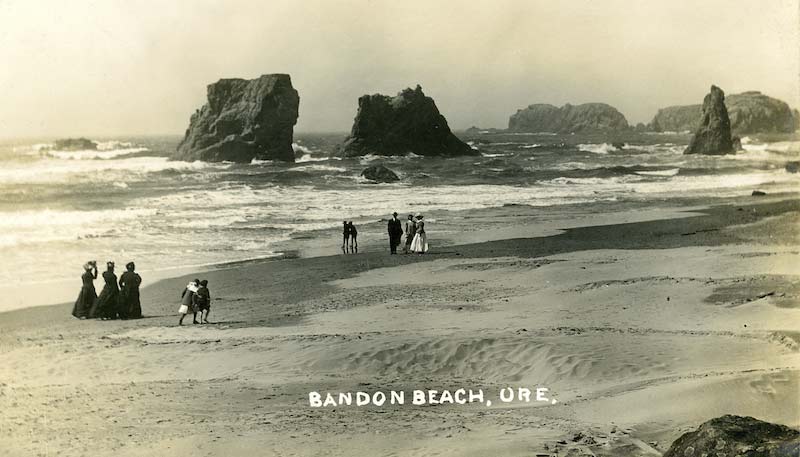
Bandon in the 1910s
All over the coast, but especially in the Bandon area, the thick yellow of the Gorse plant is not a welcome sight – but it's not avoidable, either. An invasive species brought here by Irish immigrant George Bennett in the late 19th century, he found it comforting because it reminded him of home as he slowly lay the foundations for the little town called Bandon.
By the 1930s, at least one scientist had warned locals this plant was going to be sour grapes, and on September 26, 1936, the predictions became horribly true. A fire just east of town found its way to the city limits, catching hold of the oily Gorse and sending the entire place into an inferno state. Witnesses reported seeing the plant nearly exploding once it caught fire, with flames leaping more than ten feet in the air above the shrub.
Just about everything in town burned, even the sidewalks. They reportedly became so hot in spots they melted.
Many residents didn't believe they needed to be evacuated, and for a time some stalled. Emergency vehicles had to hold guard at locals' backs at times as they fled, to keep the fire from overwhelming those on the run. Eventually, all residents wound up on the beach, with many having to hide behind logs that were in turn getting licked by the fire, with some constantly dusting the logs with sand to keep them from burning.
In the end, some ten people died and almost every building in Bandon was burned, including homes. Some died later due to their injuries; one elderly man died of a heart attack in the midst of it. The town was resilient, however, and by a year later much of it had been rebuilt.
The Great Depoe Bay Fire
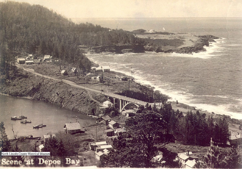
Depoe Bay in the '40s (courtesy North Lincoln County Historical Museum)
In mid September of 1936, Bandon was about to have its run-in with flames, but near Depoe Bay a forest fire had begun a few miles to the east. By September 22, the fire had reignited after a calming period and – fanned by heavy east winds – it jumped the highway. This reportedly created a roaring sound, and quickly caught just about every foliage at hand on fire.
Some 200 men eventually joined the fire fight, including some tourists who had driven out to just watch at first. Pumps were jammed into any body of water to hit the flames with. Most locals were told to evacuate their homes, and when some resisted, the local fire marshal acquired federal law authority to back him up.
Many families simply moved their stuff into the streets, away from any possible flame sources. Still, after the conflagration, the people of Depoe Bay noticed there was scarcely an object – including homes – that did not have a blackened mark from the flames. 12 families lost their homes, but no one lost their lives. Some two and a half miles of central Oregon coast was burned before it came under control on September 28. See the Great Depoe Bay Fire for full story.
Oregon Coast Hotels in this area - South Coast Hotels - Where to eat - Maps - Virtual Tours
Cannon Beach Lodging
Nehalem Bay Lodgings
Manzanita Hotels, Lodging
Three Capes Lodging
Pacific City Hotels, Lodging
Lincoln City Lodging
Depoe Bay Lodging
Newport Lodging
Waldport Lodging
Yachats Lodging
Oregon Coast Vacation Rentals
Oregon Coast Lodging Specials
More About Oregon Coast hotels, lodging.....
More About Oregon Coast Restaurants, Dining.....
LATEST Related Oregon Coast Articles
30th annual Valentine?s Day Celebration of Renewal and Commitment on Saturday, Feb. 14. Yachats events, Florence events, Waldport events, Newport
Oregon Coast's First 'Reviews' Came 220 Years Ago: Lewis and Clark in January
1806 here made its mark in history from Washington, Astoria, Warrenton to Seaside and Cannon Beach
McMinnville Oregon Weather - Forecasts, Sky Cams, Alerts, Current Conditions
Weather forecasts, live sky cams, alerts and current conditions for McMinnville, Oregon. Portland, Hillsboro, Tualatin
S. Oregon Coast's Cape Blanco Celebrating 155 Years: A Look At That Lens
Historical look at the two lenses used since 1870. Port Orford events, history
Newport Truly Fire: Central Oregon Coast's Legendary Inn at Nye Beach
Newport Hotel Review: eco-friendly, upscale and downright glowing. Newport hotel reviews, Newport hotel news
New and Old Pals in Lincoln City As Feb Unveils Different Features for Oregon...
Food truck gets a building, a new park, Lincoln City events, vintage shop digital tour, more. Lincoln City?s annual Retro Expo returns Feb. 6 - 16, Winter Waters dining series, Natural Arts 'n Science on Feb. 19, Finders Keepers
Washington Coast's Cape Disappointment State Construction - Some Closures
Some camping loops and beach accesses closed until spring. Hotel news
126 Years Ago: Cannon That Gave Two Oregon Coast Towns Their Names Was Pulled...
Thursday was a little landmark in history for two towns named Cannon Beach
Back to Oregon Coast
Contact Advertise on BeachConnection.net
All Content, unless otherwise attributed, copyright BeachConnection.net Unauthorized use or publication is not permitted


