Coos Bay Area Discoveries: New South Oregon Coast History, Scientific Finds
Published 12/05/22 at 6:39 PM
By Oregon Coast Beach Connection staff
Includes exclusive listings; some specials in winter
In Cannon Beach:
Includes rentals not listed anywhere else
In Manzanita, Wheeler, Rockaway Beach:
Some specials for winter
In Pacific City, Oceanside:
Some specials for winter
In Lincoln City:
Some specials for winter
In Depoe Bay, Gleneden Beach:
Some specials for winter
In Newport:
Look for some specials
In Waldport
Some specials for winter
In Yachats, Florence
Some specials for winter
Southern Oregon Coast Hotels / Lodgings
Reedsport to Brookings, places to stay; winter deals
(Coos Bay, Oregon) – That old saying of “what's old is new again” really has some interesting dimensions in the Coos Bay area. When it comes to finding something new and even really surprising in the history of the area or some aspect of science on this part of the south coast, it doesn't just mean more knowledge. It also means the visitor has yet another aspect to check out. (Photo courtesy Steven Greif, Coos HIstory Museum)
Just when you think you've seen it all in the Coos Bay / Charleston / North Bend – wow, are you wrong. Check out what's been discovered here in the last two years.
Ghost Forests at Sunset Bay. Ancient ghost forests on the Oregon coast are kind of a big deal these days – or at least the ones in Neskowin are. They're craggy and eerie-looking, but they're by far and away not the only such finds on this coastline.
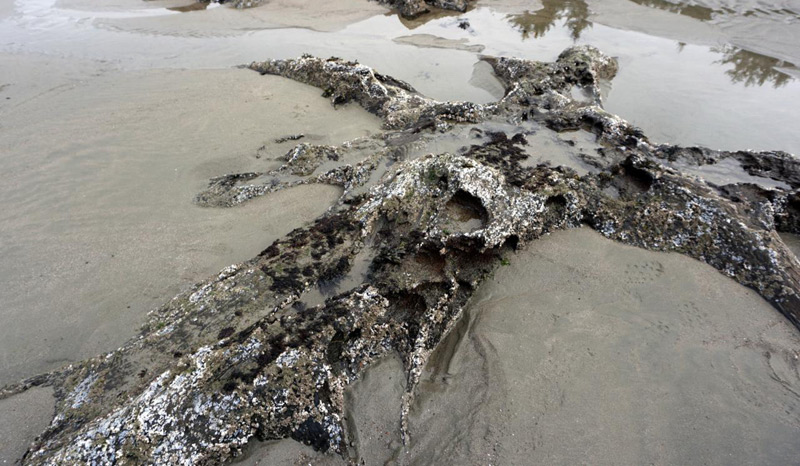
Photo courtesy Brent Lerwill
One set down near Coos Bay is rather spectacular and visible almost year-round: the ghost forests of Sunset Bay. Yet you never hear about them.
It was CoastWatch volunteer and Charleston resident Brent Lerwill that let Oregon Coast Beach Connection know about them nearly two years ago, and there was much to learn about them, as well as plenty of myths to bust.
They have officially been carbon-dated at 800 AD – about the time the Vikings started raiding England. What created them is a bit of a mystery: it's not as certain as the explanation for other beach ghost forests. What Oregon Coast Beach Connection found was a winding path through various past research with a few twists and turns.
In any case, you now know they're here. The Unheralded Ghost Forests of South Oregon Coast / Coos Bay in Photos The stumps at Sunset Bay at Coos Bay / Charleston are intricate and their origin murky
Courtesy Oregon's Adventure Coast
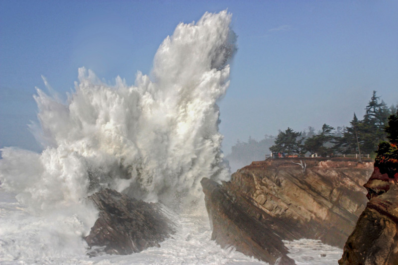
The Mammoth Waves of Shore Acres State Park. One of the largest attractions along this region is down on the south coast at Shore Acres State Park. It's large in terms of tourism numbers and in its physical size. Waves here get compounded and given more energy by a unique terrain beneath the surface, and then they hit a big barrier – all together a bunch of elements that create monsters from the sea.
These often tower over the clifftop by a hundred feet or more.
What is that terrain? How does that happen? Two regional geologists helped us figure it out and the resulting interviews were awe-inspiring. Also, if you ever wondered how those wave heights are measured, you get clued in on that too. Why Shore Acres Waves Are So Big: Height Measurement, Geology | S. Oregon Coast What is it that makes this place so different? How are waves measured?
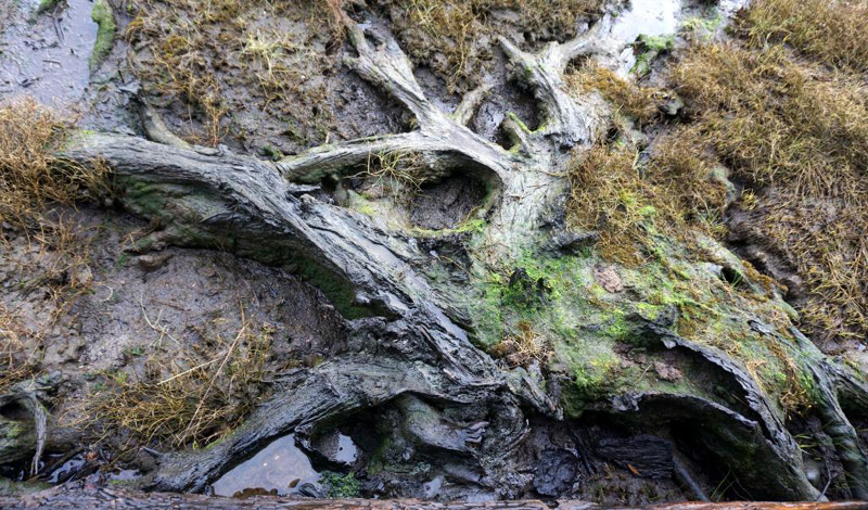
Photo courtesy Brent Lerwill
“New” Ghost Forest Near Coos Bay Discovered. It's not often a local media company gets to help make a scientific discovery, but that happened a couple years ago when Charleston's Lerwill told us about a set of worn-down stumps near his slightly remote property.
Checking in with geologists Oregon Coast Beach Connection was able to confirm: yes, indeed, these were ghost forest stumps not yet documented. These were different than those found on beaches, however. This group was killed and then preserved by debris from the 1700 tsnami that happened because of a massive earthquake. Beach ghost stumps happened because of a slow change in environment, where the area slowly became a swamp. It was not the quake theory like those aforementioned stumps – people and media constantly get those mixed up (See Explanation of Ghost Forests Wrong).
This particular bunch was located along an estuary around Charleston, and estuaries are where you'll often find 300-year-old ghost stumps from that event. See New Ghost Forest on S. Oregon Coast Remains of 1700 Megathrust Quake, Tsunami A new set of stumps is documented at Coos Bay and they're fascinating
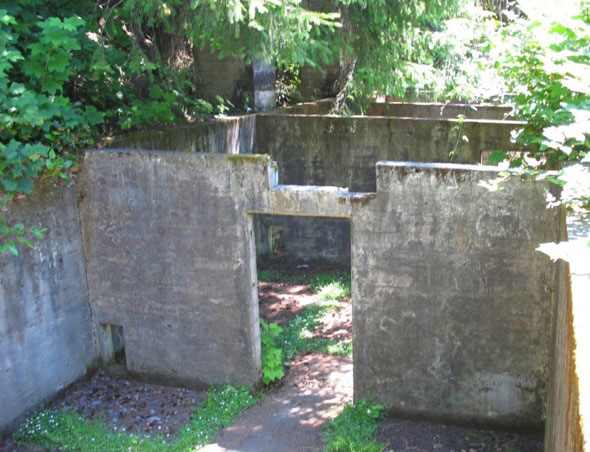
Photo courtesy Steven Greif, Coos HIstory Museum
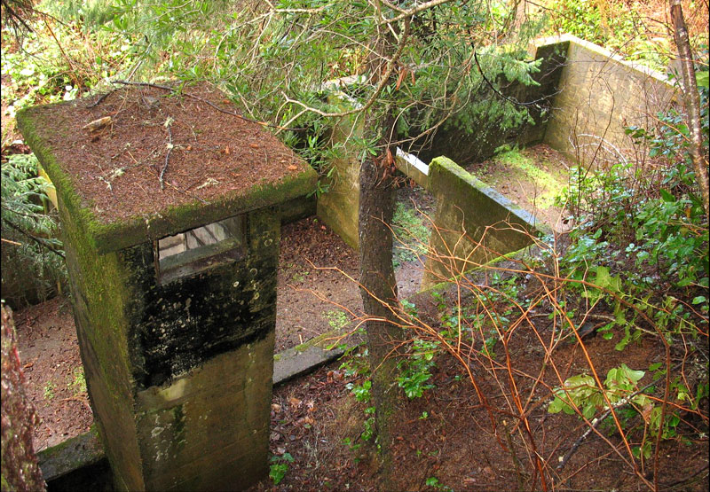
Cape Arago's Radar Bunker. If ancient, almost prehistoric stumps don't thrill you, then maybe a startling surprise of World War II history might. At Cape Arago, near the parking lot, there's the ruins-like remnant of an old radar bunker known as Station B-28, utilizing the SCR-270 radar equipment technology at the time. The mission was to not just look for incoming enemy aircraft but also to assist U.S. planes in their patrols and maneuvers.
It's still there, but it's impossible to tell what it was meant for unless you know that segment of history well. Radar Bunker at Coos Bay's Cape Arago: Living S. Oregon Coast History This one was called Station B-28, utilizing the SCR-270 radar equipment
Santa Clara Shipwreck Terror. There have been so many shipwrecks along this part of the south coast, especially from Coos Bay down through Bandon. One stands out, which happened in 1915. The SS Santa Clara was one of the deadliest in the state's history, where 16 people lost their lives in a few hours.
The ship struck a shoal of some sort around Sunset Bay, in the midst of conditions that were absolutely terrifying. Still, with the ship obviously going nowhere, the captain ordered people into lifeboats where quite a few were taken by the elements.
It's a tense and sad tale. Coos Bay's Santa Clara Shipwreck Among Deadliest on Oregon Coast November 2, 1915 she was on her way into Coos Bay
Oregon Coast Hotels in this area - South Coast Hotels - Where to eat - Maps - Virtual Tours
Cannon Beach Lodging
Nehalem Bay Lodgings
Manzanita Hotels, Lodging
Three Capes Lodging
Pacific City Hotels, Lodging
Lincoln City Lodging
Depoe Bay Lodging
Newport Lodging
Waldport Lodging
Yachats Lodging
Oregon Coast Vacation Rentals
Oregon Coast Lodging Specials
More About Oregon Coast hotels, lodging.....
More About Oregon Coast Restaurants, Dining.....
LATEST Related Oregon Coast Articles
Circles in the Sand April?August; Tour de Fronds on June 20. Bandon events
Newport Police Investigate Two Stabbings and a Shooting Near Oregon Coast's H...
A man was shot as he was allegedly stabbing his second victim
Arch at Neptune Beach Near Yachats: Rising and Falling of Oregon Coast Landmark
A small beauty that changes height at times between Florence and Yachats
Winds, Rain Slam Oregon and Coast: Power Outages, Debris and More Coming
Damage at Astoria, Lincoln City: many power outages, major debris. weather, traffic
N. Oregon Coast's Ecola State Park Closed Due to Landslides That Cracked Road
This part of Cannon Beach is prone to hillside movement: Indefinate closure. Weather, safety
Flooding Shuts Down Roads in Washington, Oregon, Coast
Road issues at Seaside, Neskowin, Hwy 6, SW Washington and more coming. Weather
The Opposite of an Exploding Whale: Oregon Coast History of 'Zombie Whales'
1952: whale would not stay buried. Was it finally entombed in cement. Marine sciences
4.5 Quake Off S. Oregon Coast After A Week of Smaller Ones
Quakes on Dec. 15, 17, 20 and last night off Coos Bay, Bandon. Geology
Back to Oregon Coast
Contact Advertise on Oregon Coast Beach Connection
All Content, unless otherwise attributed, copyright Oregon Coast Beach Connection. Unauthorized use or publication is not permitted


