How Did the Oregon Coast Come to Be - and When?
Updated Periodically
By Oregon Coast Beach Connection Staff
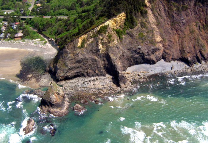
(Manzanita, Oregon) – Look around the Oregon coast and you may wonder: how did all this come to be? Or for that matter: when? (Above: aerial view of Arch Cape).
It’s an insanely complex answer. But the shortest answer, arrived at by skipping over whole gobs of important stuff: probably about ten million years ago the shoreline that we know as the Oregon coast started to exist.
Includes exclusive listings; some specials in winter
In Cannon Beach:
Includes rentals not listed anywhere else
In Manzanita, Wheeler, Rockaway Beach:
Some specials for winter
In Pacific City, Oceanside:
Some specials for winter
In Lincoln City:
Some specials for winter
In Depoe Bay, Gleneden Beach:
Some specials for winter
In Newport:
Look for some specials
In Waldport
Some specials for winter
In Yachats, Florence
Some specials for winter
But wait, there’s more: ice ages came later and changed the ocean levels, drastically shifting things even more. Back and forth the coastline went.
Before that, the continental plates had this coastline much farther east.
Trying to figure out when the Oregon coast as we see it came to be is really quite the rabbit hole. There were times it looked similar to now. Then it shifted its look and layout quite a bit. Then it came back. Then it changed again.
It’s enough to even give Dr. Who a headache even with his/her time machine. Still, it’s fascinating beyond belief.
Tom Horning, Seaside geologist and resident, points to a huge array of things going on. The continental plates shifted westward, just as a massive hole in the Earth’s crust (the same one that powers Yellowstone National Park) poured out lava flow after flow over some 300 miles and created the Columbia River and many of the headlands we now know. That was roughly 15 million years ago. Places like Tillamook Head or Neahkahnie Mountain were of this origin. Parts of Oregon rose and fell, then rose again, including the Coast Range.
If you really want to trace the origin of this shoreline all the way back, you have to go as far as at least 270 million years ago when there were no continents. There was one massive continent known as Pangea, which began breaking up 200 million years ago. And that’s only the most recent of such super continents. Yes, there were others.
Horning said the earliest most recognizable version of the Oregon coast started happening about 190 million years later, after all the big lava flows had finished rampaging across the area. That was about 14 million years ago. Also around that time, the mudstones that make up the bottom of the beaches at places from Yachats up to Astoria came to be.
“Probably around 10 million years ago, the Coast Range as we know it had again become emergent and was rising faster than erosion was destroying it,” Horning said. “From then to the present, the shoreline has been approximately at its present position, except during pronounced Ice Age sea level changes of as much as 400 to 500 ft.”
Horning said that for much of the last two million years the continental shelf was getting flooded now and again, but mostly it was a “coastal plain covered with spruce forests, lakes, and migrating sand dunes.”
The tricky, trippy part: the continental shelf he’s referring to is the area where the water depths are now around 500 to 600 feet. We’re technically living in a time that may be a bit unusual in the grand scheme of things. Ocean levels now are so high they cover the stretch of the continent some 500 feet up from where shorelines and beaches normally were.
“But for the past 2 million years, sea level has been lower than it is now and the shoreline has typically been very close to the edge of the continental shelf, or where water depths are near 500 to 600 ft.,” Horning said.
500 feet is the difference in height between Cape Foulweather’s top point and the ocean, if you need to visualize it.
There’s a lot more than this that went on to form what we know today, but continental drift is probably the largest factor. For instance, 70 million years ago the shoreline was around where Silver Creek Falls State Park is now. Horning said around 41 million years ago the great, big, nasty subduction zone (where all the earthquakes come from) finally arrived at its current spot some 200 miles or more off this coast. Before then it was much farther inland.
Meanwhile, the prehistoric coastline kept marching westward.
At 30 million years ago, the continental slope was lifted up above sea level and then sank back down about 18 million years ago or so. By about 15 million years ago – only three million years later – a whole lot of mudstones accumulated beneath the waves and built so high that the shoreline retreated back inland about 20 miles or more.
Fast forward back again to two million years ago and – as Horning previously said – things began to look the way we know it.

To sum it up: the shoreline itself was in approximately this spot about ten million years ago, whereas it had been farther east before that. But it was two million years ago before things might’ve become recognizable to human eyes, if they could see then and now.
Even so, lots has changed in 10,000 years and less. Ice ages came and went. Back about that time, a massive ice damn broke in what is now Montana and with it came hundreds of feet of water that carved out many of the landmarks we see in the Gorge, the Willamette valley, the Coast Range and even some of the beaches.
As little as 3,000 years ago, there were massive dunes covering spots like Newport’s Yaquina Head which are now gone. 1200 short years ago the location of the Necanicum River in Seaside was likely (perhaps almost overnight) shifted a half mile to the north by a massive tsunami that struck back then. A mere 300 years ago the last enormous tsunami came through and left little ghost forests in river marshes (not the ghost forests on the beaches - those are a different origin).
If you went back in time and tried to recognize landmarks, you might find it difficult. Never mind the lack of good morning coffee two million years ago.
To add even more craziness to all this geologic haziness: the north Oregon coast is understood much more than the central and southern Oregon coast. Up north, much of the basalt rock and mudstones have been better preserved. From Lincoln County southward, scientists aren't as sure about what happened as often as up north.
The south coast, however, is much older and much more of a mish mash; thoroughly complex. In a single beach there may be layers 50 million years old, another section 140 million years old, etc. An example: How Bandon's Face Rock Was Created A Wild S. Oregon Coast Geologic Tale. On top of it, various sections joined onto the south coast from elsewhere.
“As for other parts of the coast, the actual position of the shoreline is not so clearly understood, as uplift and erosion have destroyed the rocks that contain the evidence we need to interpret the environment of deposition,” Horning said. “Presumably, the shoreline was somewhere between the summit of the Coast Range and 20 miles west of the modern beach. Still a bit of a mystery.” Oregon Coast Lodgings in this area - Where to eat - Maps - Virtual Tours = More Oregon Coast Geology


Cannon Beach Lodging
Nehalem Bay Lodgings
Manzanita Hotels, Lodging
Three Capes Lodging
Pacific City Hotels, Lodging
Lincoln City Lodging
Depoe Bay Lodging
Newport Lodging
Waldport Lodging
Yachats Lodging
Oregon Coast Vacation Rentals
Oregon Coast Lodging Specials

More About Oregon Coast hotels, lodging.....
More About Oregon Coast Restaurants, Dining.....


LATEST Related Oregon Coast Articles
Near MP 8 on Hwy 26 to Seaside / Cannon Beach
California Man Dies After Falling Off S. Oregon Coast Cliff Near Natural Brid...
The man had become separated from his wife on the trail. Brookings
US Coast Guard Rescues in April Include 2 Persons, 2 Dogs Off Washington and ...
One near Brookings involving two dogs; other near Queets
Waldport's Beach, Bike 'n Blues Fest Slams Into Central Oregon Coast in May
May 4: a festival that's grown by leaps and bounds. Waldport events, Yachats events, Newport events
Discovering Spring, Summer Along Central Oregon Coast: Hints from Pacific Cit...
A kind of summer preview from Pacific City, Newport, Depoe Bay, Yachats, Florence
Florence, Oregon's Rhody Fest Gears Up for May's Big Start on Central Coast
117th edition for its run of May 16 to 19. Florence events
Winning Photos in Oregon Coast King Tides Photo Contest Announced
Incredible situations and adrenaline-pumping images. Weather
Outstanding Hotels / Places to Stay at Gold Beach: Quirky Gems of S. Oregon C...
Gold Beach boasts a lot more than many may know. Gold Beach hotel reviews
Back to Oregon Coast
Contact Advertise on BeachConnection.net
All Content, unless otherwise attributed, copyright BeachConnection.net Unauthorized use or publication is not permitted

Oregon
Coast Hotels
S. Coast Hotels
Seaside Hotels
Cannon
Beach Hotels
Nehalem Bay Lodgings
Manzanita Hotels, Lodging
Rockaway Beach Hotels
Three Capes Lodging
Pacific City Hotels, Lodging
Lincoln
City Lodging
Depoe
Bay Hotels
Newport Hotels
Waldport Lodging
Yachats
Lodging
Oregon
Coast Vacation Rentals
Oregon
Coast Lodging Specials
South Coast Hotels
Dining
Guide
Seaside
Cannon
Beach Dining
Manzanita,
Rockaway, Wheeler Dining
Pacific
City, Oceanside, Netarts, Tierra Del Mar Restaurants
Tillamook
Bay Restaurants, Dining
Lincoln
City Dining, Restaurants
Depoe
Bay Restaurants, Dining
Newport Restaurants, Dining
Waldport,
Yachats Restaurants, Dining
Florence Restaurants, Dining
Restaurant
Reviews
Coast
Events Calendar
Astoria
Seaside,
Cannon Beach Calendar
Manzanita,
Rockaway Events
Tillamook,
Pacific City Calendar
Lincoln
City Events Calendar
Newport,
Depoe Bay Events Calendar
Yachats Events Calendar
Oregon Coast Complete Guides every beach access, attraction
Search for Oregon Coast Subjects, Articles
Explore Every Beach Spot


News Headlines from All Over Oregon Need to scan Oregon headlines? Constantly updated news from all over Oregon: a comprehensive, up-to-the-minute display of news headlines from a variety of media
Oregon Coast Oceanfront Lodging, Hotels, Rentals
Book Coastal Lodging Now
Booking.com