Tales of the End of a South Oregon Coast Lighthouse: Chief's Island and Arago Light
Published 10/28/22 at 5:33 PM
By Oregon Coast Beach Connection staff
Includes exclusive listings; some specials in winter
In Cannon Beach:
Includes rentals not listed anywhere else
In Manzanita, Wheeler, Rockaway Beach:
Some specials for winter
In Pacific City, Oceanside:
Some specials for winter
In Lincoln City:
Some specials for winter
In Depoe Bay, Gleneden Beach:
Some specials for winter
In Newport:
Look for some specials
In Waldport
Some specials for winter
In Yachats, Florence
Some specials for winter
Southern Oregon Coast Hotels / Lodgings
Reedsport to Brookings, places to stay; winter deals
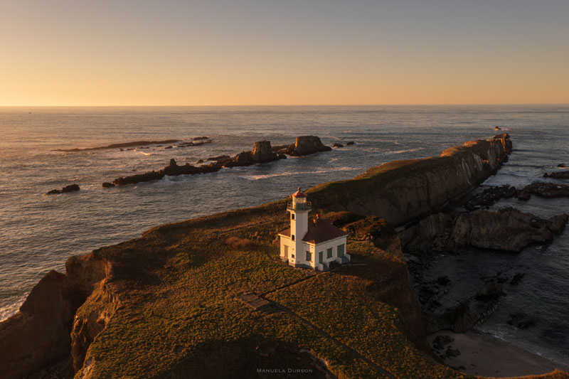
(Charleston, Oregon) - On August 3, 2013, there was an important moment in Oregon coast history that now lies quite a bit below the radar. It was when local tribes got back something precious that was stolen from them some 150 years before. Cape Arago's lighthouse - near Coos Bay – originally known as Chief's Island, was signed over to the Confederated Tribes of Coos, Lower Umpqua and Sisulaw. In a ceremony led by Captain Mark Reynolds, Commander of Coast Guard Sector North Bend, the headland that housed a lighthouse since the 1860s and even a Coast Guard station for awhile went back into the right hands. (Cape Arago Lighthouse near Coos Bay, courtesy Manuela Durson - see Manuela Durson Fine Arts for more)
European history around this south Oregon coast landmark goes back to 1778, when Captain Robert Cook sailed past and named this spot Gregory Point. Regional tribes go back much farther here. According to carbon dating, Chief's Island had humans on it for 1,500 to as much as 2,100 years ago.
Chief's Island / Gregory Point has a variety of tales to tell.
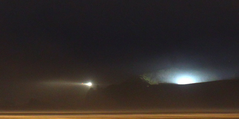
Above: lighthouse glow, photo Oregon Coast Beach Connection
The area was named Chief's Island by local tribes because it was traditionally where the chief had his dwelling. Yet there are plenty of signs of it being a village on and off over those 1,000 or more years. It's a known archaeological site, part of why it's deemed so important.
Going back even farther, the island is made of a kind of sandstone and geologically unstable. Some predictions see the area with the lighthouse caving in over the next decade or so.
Cape Arago Lighthouse is definitely not the only story on this little south Oregon coast island. But it's a big one. You can see the full history of Cape Arago lighthouse here, Surprise History: There Were Three Cape Arago Lighthouses on S. Oregon Coast .
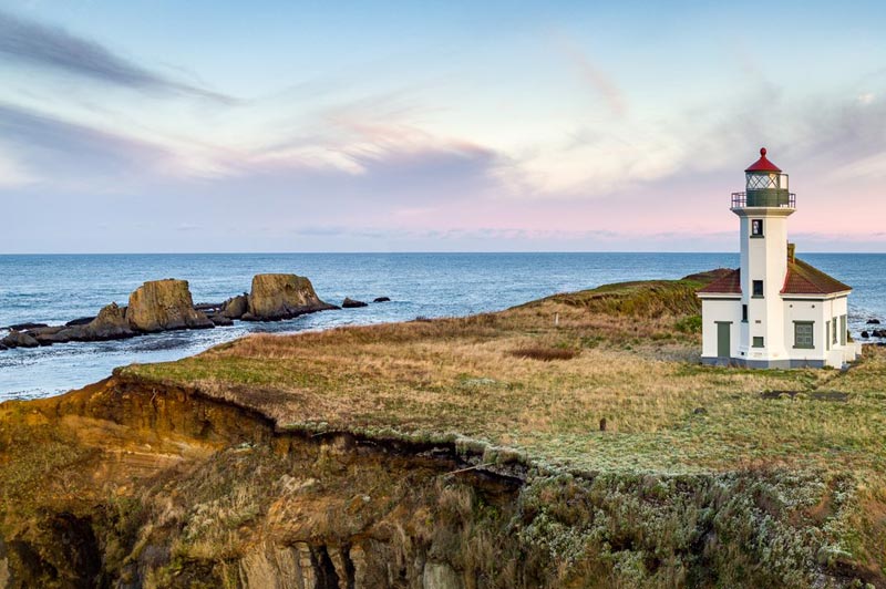
Photo courtesy Oregon's Adventure Coast
The last days of the island in U.S. hands illustrate this fragility well. According to a 2005 article by the Statesman Journal, one local had seen a new hole in the area emerge. A storm in February of that year caused her to notice it. Waves started coming right through from the other side, and all of a sudden you could see right through the little island.
Back then, the Bureau of Land Management said you could throw millions of dollars at the thing and it would still fall away.
Nearby, on the cliffs overlooking Lighthouse Beach, one elderly woman had firsthand witness to how unstable that area was. The cliffs are made of the same stuff as Chief's Island.
Irene Quick had purchased oceanfront land at this spot in the '40s, starting with building a cabin there. Running water didn't arrive until the '70s, so for thirty years they had an outhouse with what was called a “million-dollar view” of the lighthouse. A full house eventually was built, but in the meantime the cliffs kept eroding away. 35 feet disappeared over the decades, even taking the outhouse with it.
The lighthouse itself was victim to this crumbling. At least one of the rebuilds of the structure had to do with the area eroding, causing Oregon coast officials to build the next one back a ways.
Quick was 90 when the Statesman Journal talked to her. She also told another tantalizing tidbit: Chief's Island was occasionally still accessible on foot during extreme low tide events.
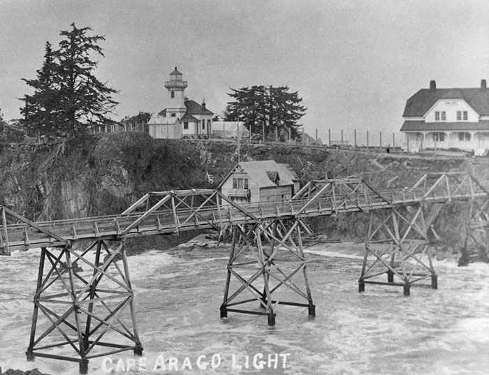
The bridge across to Cape Arago Light, many decades ago
In the mid 2000s, she was given a chance to be one of the last people to walk over the rickety bridge to see the lighthouse. By this time, it had been closed off for years. Much of that was due to the archaeological significance of the place, the fact it was sacred to local tribes because so many ancestors were there, and safety concerns. In those final years of the bridge, however, it was dangerous, shaky and slippery. Even local tribes had to get permits to go across for ceremonies or visits with their forebears.
One group in November 2003 were one of the last forays across, and according to accounts the Coast Guard only let two or three at a time walk over that unstable bridge.
For a time charter boats used to get closer for a better look, but not allowed to make landfall.
While the Cape Arago Lighthouse was placed on the National Register of Historic Places in 1993, its days as a viewable attraction were numbered. Even then, the process was slowly brewing to bring it back to tribes and cut off all access. In the early 2000s, that process began moving forward in earnest, slowly working its way through Washington, D.C.
The light was deactivated in 2006.
By 2012, a year before the signing ceremony, the bridge was finally dismantled. Just before that, Coast Guard engineering officer Lt. Jennifer Lopez was interviewed by the Associated Press saying the lighthouse was getting patched up and readied for retirement. Walls were getting fixed, sealed and repainted to better its condition and make it water-tight.
Oregon Coast Hotels in this area - South Coast Hotels - Where to eat - Maps - Virtual Tours


Cannon Beach Lodging
Nehalem Bay Lodgings
Manzanita Hotels, Lodging
Three Capes Lodging
Pacific City Hotels, Lodging
Lincoln City Lodging
Depoe Bay Lodging
Newport Lodging
Waldport Lodging
Yachats Lodging
Oregon Coast Vacation Rentals
Oregon Coast Lodging Specials


More About Oregon Coast hotels, lodging.....
More About Oregon Coast Restaurants, Dining.....


LATEST Related Oregon Coast Articles
20 May 2026 at 11:34pm
Even a chance of heat risk, but possibly lots of rain on Monday. Weather, Salem, Burns, Medford, Bend, Eugene, Salem, Corvallis, Ontario, The Dalles
Woman Dies After 40-Ft Fall at Oregon Coast Attraction
4 Jun 2026 at 8:29am
Someone wandered beyond the fences at Devil's Punchbowl. Rescue, US Coast Guard, Depoe Bay, Newport, Lincoln City, weather
U.S. Issues Some International Travel Restrictions Due to New Ebola Virus Strain
22 May 2026 at 9:34pm
No cases are being monitored within the U.S.; restrictions only for some incoming travelers. Safety
Oregon Coast Highway 101 Road Conditions, Traffic - Coast Range Passes
22 May 2026 at 9:34pm
Check out all traffic between Astoria, Seaside, Cannon Beach, Pacific City, Newport, Florence, Coos Bay, Bandon, Brookings
A big change for central Oregon coast's Lincoln City Summer Kite Festival
18 May 2026 at 9:54am
June 27 - 28: but with a hefty change: moved from the D River to Chinook Winds Resort. Lincoln City events
Oregon Coast Authorities Offer Tips on Safe Vehicle Travel with Your Pet
8 Jun 2026 at 12:09am
Lincoln County Sheriffs urge take these extra precautions. Traffic
Potential for Lightning / Wind Storms in Valley, Cascades; South Oregon Coast...
27 May 2026 at 9:15pm
Risk of dangerous waves Thurs; dramatic lightning, hail, wind Cascades, NW Oregon. Weather
South Oregon Coast All Summer: Nature, History Events at Bandon's Bullards Be...
8 Jun 2026 at 12:09am
From now through August there a ton of Bandon events. Literally
Back to Oregon Coast
Contact Advertise on Oregon Coast Beach Connection
All Content, unless otherwise attributed, copyright Oregon Coast Beach Connection. Unauthorized use or publication is not permitted

Oregon
Coast Hotels
S. Coast Hotels
Astoria/Warrenton Hotels
Seaside Hotels
Cannon
Beach Hotels
Nehalem Bay Lodgings
Manzanita Hotels, Lodging
Rockaway Beach Hotels
Three Capes Lodging
Pacific City Hotels, Lodging
Lincoln
City Lodging
Depoe
Bay Hotels
Newport Hotels
Waldport Lodging
Yachats
Lodging
Oregon
Coast Vacation Rentals
Oregon
Coast Lodging Specials
South Coast Hotels
Dining
Guide
Seaside
Cannon
Beach Dining
Manzanita,
Rockaway, Wheeler Dining
Pacific
City, Oceanside, Netarts, Tierra Del Mar Restaurants
Tillamook
Bay Restaurants, Dining
Lincoln
City Dining, Restaurants
Depoe
Bay Restaurants, Dining
Newport Restaurants, Dining
Waldport,
Yachats Restaurants, Dining
Florence Restaurants, Dining
Restaurant
Reviews
Coast
Events Calendar
Astoria
Seaside,
Cannon Beach Calendar
Manzanita,
Rockaway Events
Tillamook,
Pacific City Calendar
Lincoln
City Events Calendar
Newport,
Depoe Bay Events Calendar
Yachats Events Calendar
Oregon Coast Complete Guides every beach access, attraction
Search for Oregon Coast Subjects, Articles
Explore Every Beach Spot


News Headlines from All Over Oregon Need to scan Oregon headlines? Constantly updated news from all over Oregon: a comprehensive, up-to-the-minute display of news headlines from a variety of media
Oregon Coast Oceanfront Lodging, Hotels, Rentals
Book Coastal Lodging Now
Booking.com