NASA Images Show Wildfire Smoke Over Seattle, Portland, Oregon / Washington Coast
Published 10/11/22 at 5:24 PM
By Oregon Coast Beach Connection staff
Includes exclusive listings; some specials in winter
In Cannon Beach:
Includes rentals not listed anywhere else
In Manzanita, Wheeler, Rockaway Beach:
Some specials for winter
In Pacific City, Oceanside:
Some specials for winter
In Lincoln City:
Some specials for winter
In Depoe Bay, Gleneden Beach:
Some specials for winter
In Newport:
Look for some specials
In Waldport
Some specials for winter
In Yachats, Florence
Some specials for winter
Southern Oregon Coast Hotels / Lodgings
Reedsport to Brookings, places to stay; winter deals
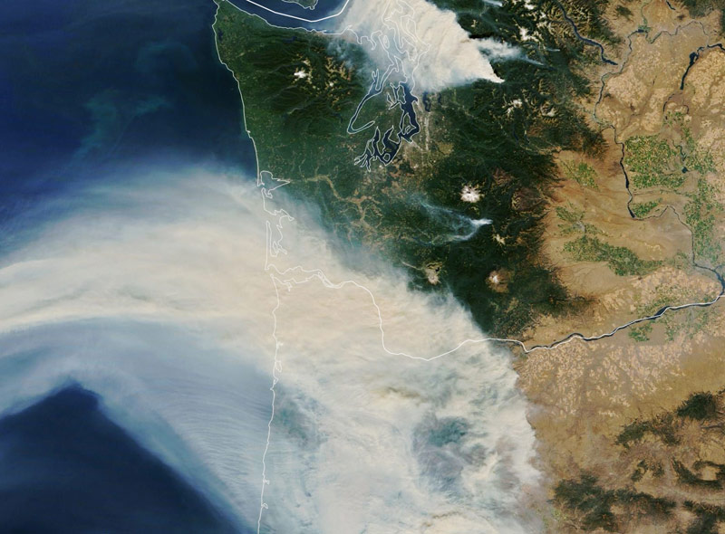
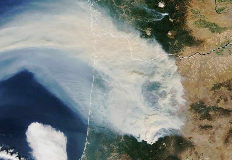
(Cannon Beach, Oregon) – Not unlike the last week or so, chunks of the Oregon coast and Washington coast were dealing with some heavy smoke haze from wildfires around the Pacific Northwest about a month ago. It made life more uncomfortable in places like the Willamette Valley and the Seattle / I-5 corridor. Some 100 wildfires burned in the U.S. this past summer (which is technically not quite over with here), and a good number of them were in this region. Oregon's Cedar Creek fire and Washington's Bolt Creek fire together ate up some 130,000 acres – and they're still going. (Photo NASA: a detail from the whole image)
It's gnarly enough when you have to breathe it, but seeing it from space adds a whole new chill to the concept. NASA Earth's MODIS and VIIRS instruments captured some of that wispy drama from above the atmosphere, and these dramatic photos of the plumes heading across the Oregon coastline and Washington coast were just released by NASA.
They show Seattle and the Puget Sound in the sights of the Bolt Creek blaze, but largely missing the Washington coast.
FULL IMAGE
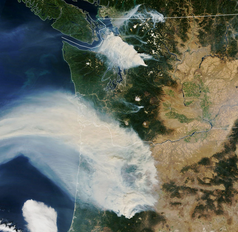
The Cedar Creek fire is the monster in this photo, taken September 10. It reaches across the Cascades, rounding one section of the mountains to some degree, where it thins out a little, and then the two streams appear to rejoin on the west side and make a darker, thicker spot – all looking a little like foam in your espresso.
The bottom edge of the smoky mass just misses Florence, and you can see Winchester Bay and Coos Bay on the south Oregon coast as the two snakelike indentations in the satellite shot.
On the northern Oregon coast, Tillamook Bay is the most prominent feature this far up, where the thickest smoke was at this time, getting even thicker around Warrenton and Astoria.
Oregon detail
Long Beach on the south Washington coast is also getting some of the worst of it on this date, with the last of it dissipating around Grays Harbor, Westport and Aberdeen.
The color NASA image comes from the Terra satellite, equipped with Moderate Resolution Imaging Spectroradiometer (MODIS). It was taken around 11 a.m. that day.
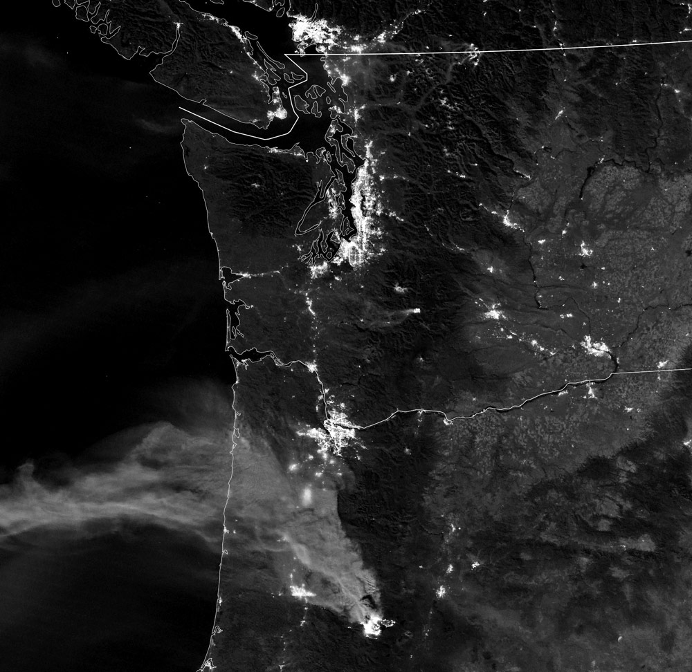
The black and white image was shot at night at 3 a.m. It was just before the Bolt Creek fire erupted, so it's noticeably missing. This one was snapped by the Visible Infrared Imaging Radiometer Suite (VIIRS) on the Suomi-NPP. The striking thing here is seeing the fires glow at night: it adds a bit more fright to the scene.
“Smoke and the fires were visible via the instrument’s day-night band, which measures nighttime light emissions and reflections,” NASA said. “In this case, some of the smoke plumes reflected light from the full Moon.”
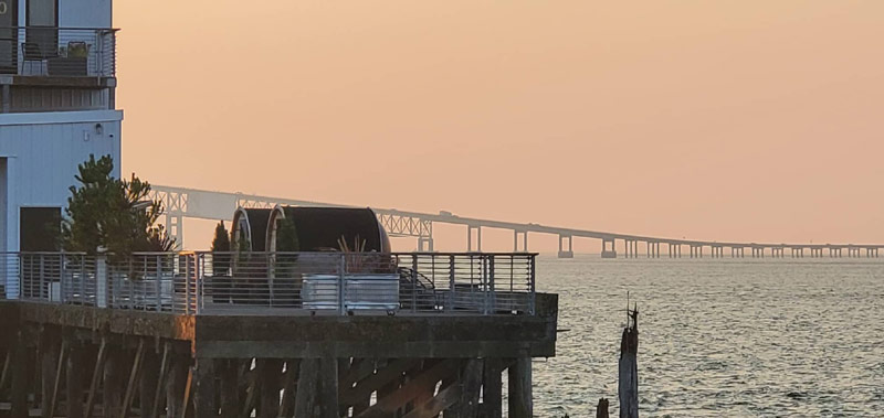
On the ground, on that very day, Oregon Coast Beach Connection had eyes in Astoria. Thanks to Angi Wildt of Angi D Wildt Gallery, there was this glimpse of the bridge and the very haze that had been captured hundreds of miles above earlier in the day.
Oregon Coast Hotels in this area - South Coast Hotels - Where to eat - Maps - Virtual Tours


Cannon Beach Lodging
Nehalem Bay Lodgings
Manzanita Hotels, Lodging
Three Capes Lodging
Pacific City Hotels, Lodging
Lincoln City Lodging
Depoe Bay Lodging
Newport Lodging
Waldport Lodging
Yachats Lodging
Oregon Coast Vacation Rentals
Oregon Coast Lodging Specials

More About Oregon Coast hotels, lodging.....
More About Oregon Coast Restaurants, Dining.....


LATEST Related Oregon Coast Articles
27 Jun 2026 at 11:23pm
The man was taken to a burn center in Portland. Video of lightning by satellite. Molalla, Clackamas County, Marion County, Wilsonville
Oregon Coast Jazz Party Announces Lineup in Newport - October
27 Jun 2026 at 11:23pm
October 2 - 4 in Nye Beach, Newport. Newport events
Oregon Officials Advice on Fireworks, Leave Them At Home If Heading to State ...
27 Jun 2026 at 11:23pm
Fireworks are banned in all state parks; Sheriffs urge caution. Safety. Astoria events, Seaside events, Cannon Beach events, Manzanita events, Rockaway Beach events, Tillamook events, Oceanside events, Pacific City events, Lincoln City events, Depoe Bay events, Newport events, Waldport events, Yachats events, Florence events, Reedsport events, North Bend events, Coos Bay events, Charleston events, Bandon events, Port Orford events, Gold Beach events, Brookings events. Weather
Absolute Complete Guide to Oregon Coast Fourth of July, 2026: All Towns
26 Jun 2026 at 6:51am
Astoria events, Seaside events, Cannon Beach events, Manzanita events, Rockaway Beach events, Tillamook events, Oceanside events, Pacific City events, Lincoln City events, Depoe Bay events, Newport events, Waldport events, Yachats events, Florence events, Reedsport events, North Bend events, Coos Bay events, Charleston events, Bandon events, Port Orford events, Gold Beach events, Brookings events. Weather
Back to Oregon Coast
Contact Advertise on Oregon Coast Beach Connection
All Content, unless otherwise attributed, copyright Oregon Coast Beach Connection. Unauthorized use or publication is not permitted

Oregon
Coast Hotels
S. Coast Hotels
Astoria/Warrenton Hotels
Seaside Hotels
Cannon
Beach Hotels
Nehalem Bay Lodgings
Manzanita Hotels, Lodging
Rockaway Beach Hotels
Three Capes Lodging
Pacific City Hotels, Lodging
Lincoln
City Lodging
Depoe
Bay Hotels
Newport Hotels
Waldport Lodging
Yachats
Lodging
Oregon
Coast Vacation Rentals
Oregon
Coast Lodging Specials
South Coast Hotels
Dining
Guide
Seaside
Cannon
Beach Dining
Manzanita,
Rockaway, Wheeler Dining
Pacific
City, Oceanside, Netarts, Tierra Del Mar Restaurants
Tillamook
Bay Restaurants, Dining
Lincoln
City Dining, Restaurants
Depoe
Bay Restaurants, Dining
Newport Restaurants, Dining
Waldport,
Yachats Restaurants, Dining
Florence Restaurants, Dining
Restaurant
Reviews
Coast
Events Calendar
Astoria
Seaside,
Cannon Beach Calendar
Manzanita,
Rockaway Events
Tillamook,
Pacific City Calendar
Lincoln
City Events Calendar
Newport,
Depoe Bay Events Calendar
Yachats Events Calendar
Oregon Coast Complete Guides every beach access, attraction
Search for Oregon Coast Subjects, Articles
Explore Every Beach Spot


News Headlines from All Over Oregon Need to scan Oregon headlines? Constantly updated news from all over Oregon: a comprehensive, up-to-the-minute display of news headlines from a variety of media
Oregon Coast Oceanfront Lodging, Hotels, Rentals
Book Coastal Lodging Now
Booking.com