Oregon Coast History Then and Now Photos: Perpetua, Waldport, Bandon, Depoe Bay
Published 03/12/23 at 4:33 PM
By Oregon Coast Beach Connection staff
Includes exclusive listings; some specials in winter
In Cannon Beach:
Includes rentals not listed anywhere else
In Manzanita, Wheeler, Rockaway Beach:
Some specials for winter
In Pacific City, Oceanside:
Some specials for winter
In Lincoln City:
Some specials for winter
In Depoe Bay, Gleneden Beach:
Some specials for winter
In Newport:
Look for some specials
In Waldport
Some specials for winter
In Yachats, Florence
Some specials for winter
Southern Oregon Coast Hotels / Lodgings
Reedsport to Brookings, places to stay; winter deals
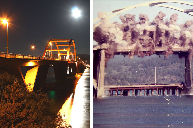
(Oregon Coast) - “Ch-ch-ch-ch-changes.....” said one extremely influential rock star some 50 years ago. That famous line from Bowie is itself history now, in a song talking about things in the present all becoming history at one point. (Above: at left, Waldport's bridge today, photo copyright Oregon Coast Beach Connection. At right, blowing up the old bridge, courtesy photo)
Certainly here on the Oregon coast, change is a constant. It's not just the waves and winds eroding stuff away and changing shape, it's progress itself, and sometimes even things returning to a more natural state by the urging of mankind. It's not always bad stuff we do.
There's a lot going on here, and the stark differences aren't something we always notice unless we see old historic photographs or we return to a fave Oregon coast beach after a decade or more.
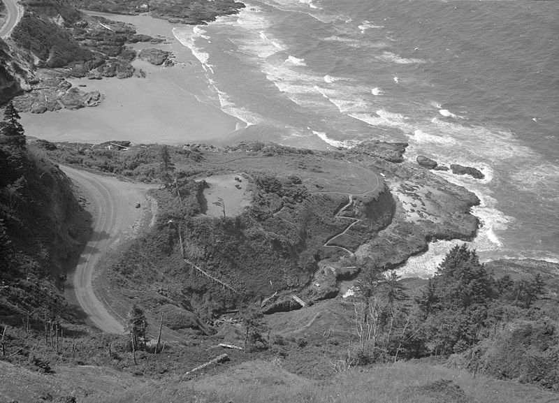
Among such examples is towering Cape Perpetua and the Devil's Churn. Above, here's what the area near Yachats looked like in the '30s. The zig-zagging pathway downward doesn't look as manicured as it does now. There's even a bridge over the Churn at the bottom – which undoubtedly didn't last long with the way Oregon coast storms like to batter the region.
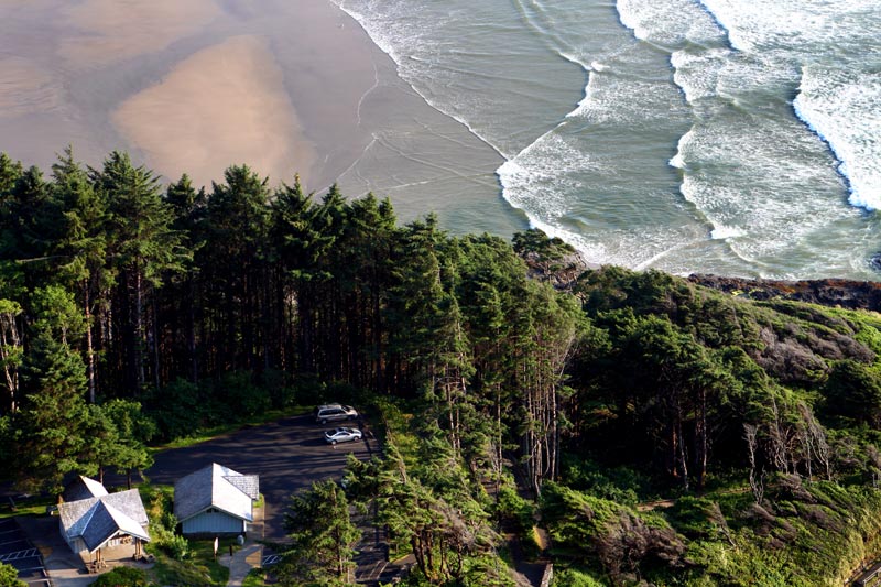
What's also striking in this before / after is sequence is the flat, cleared area where the parking lot and the restrooms are now.
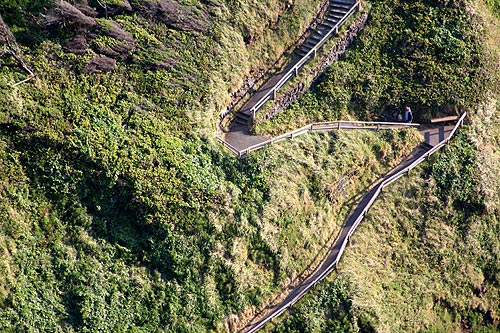
Also compare and contrast the modern vs. 100 years ago: the trees now are so much higher than they were then.
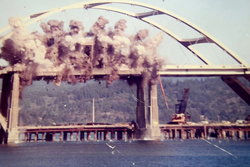
Blowing Up of Alsea Bay Bridge in Waldport. The famed Alsea Bay Bridge you now see in Waldport isn't as old as the Art Deco architecture implies. Waldport's largest feature is nearly 3,000 feet long and is one of the prime connections across Highway 101. But it's the second bridge here, after the first one was blown up in 1991.
The original, designed by Conde McCullough, was finally the big connection for the central Oregon coast after Highway 101 had gone up. McCullough's famed accomplishment was completed in 1936 with a huge celebration that is said to have had as many as 15,000 present (estimates differ.) That first bridge for Waldport started to get run down later in life, with rust being one of the primary problems. Chunks of concrete from its underside started to crack off and hit the Aslea Bay as well.
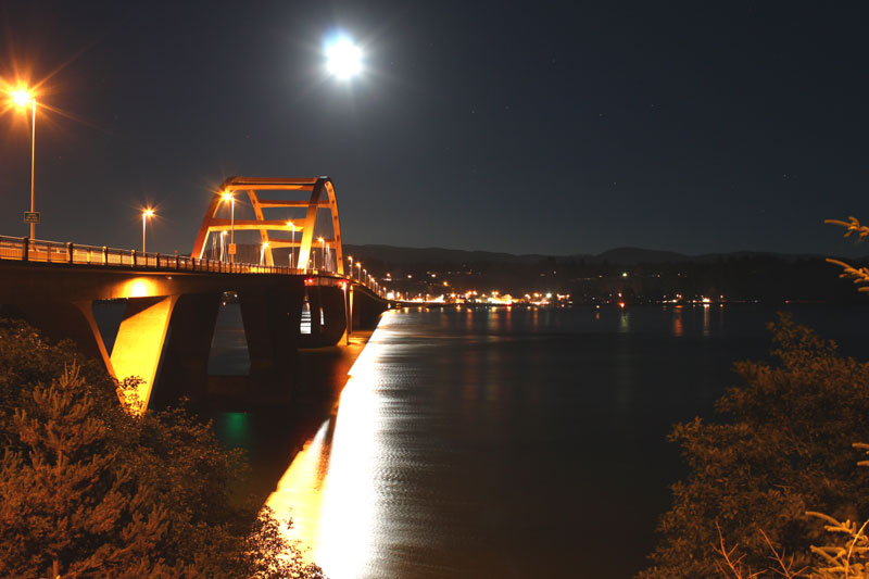
In 1972 it was decided to phase this one out and build a new Alsea Bay Bridge. Construction on that began in the late '80s, side by side with the old one. Completed sometime in 1991, there was another huge dedication in August – known as the largest celebration since the first one in '36. The yellow crystal lights and the Art Deco-style stone pillars they sat in were retained with the new Oregon coast bridge, as well as other design elements, keeping the tradition.
Sometime after that, demolition slowly began on the historic Waldport bridge, starting with slowly dismantling parts of it. Finally, it was blown apart with dynamite and the remnants slowly cleared over the next several months. Hotels in Waldport - Where to eat - Waldport, Seal Rock Maps and Virtual Tours
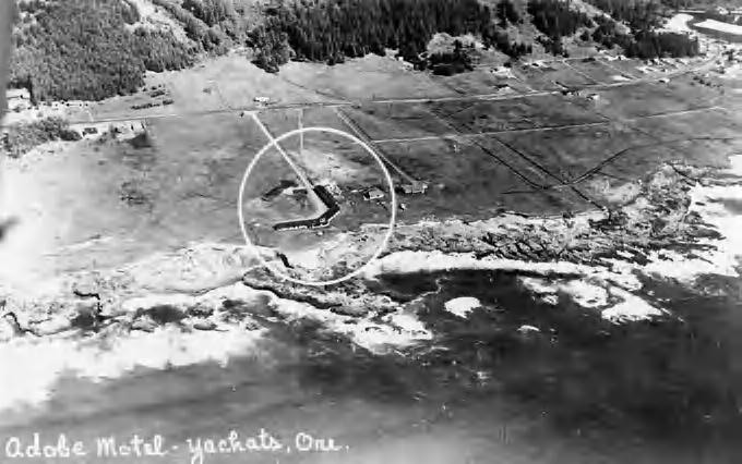
Yachats By Air in the Past. Oregon Coast Beach Connection has been lucky enough to snag two historical aerials of Yachats.
First up is Yachats in 1959. It makes a point of the Adobe Motel back then, now known as the Adobe Resort for at least three decades. What's remarkable is the lack of anything else nearby. The adorable central Oregon coast town is essentially bare of mankind's constructs. It's all still wild country.
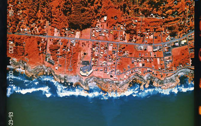
Fast forward to 1993, there's this infrared shot from ODFW. Infrared shows heat sources, and the agency was likely looking at plant life in the area. The Adobe has a strikingly different configuration, and it's thicker than before. Meanwhile, there's a ton of other buildings and roads by this time, looking more or less like it does today, even just 30 years after the first shot. Hotels in Yachats - Where to eat - Yachats Maps and Virtual Tours
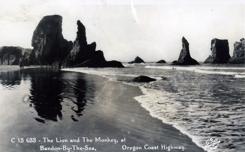
Bandon Early in the Century. These old photographs can really reveal some fascinating discoveries, especially with this one provided by the Bandon Historical Museum. Back about 100 years ago or so, the southern Oregon coast town had completely different names for its landmark rock structures. Then, this set contained the Lion and the Monkey – though it's hard to be sure which is which.
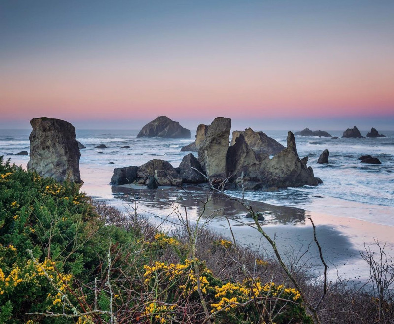
Photo Manuela Durson - see Manuela Durson Fine Arts for more.
Fast forward to now, the rock structure that's prominent in both shots is known as the Castle. None of Bandon's rocks here are officially named by the state or the city, and consequently some folks in town have different names for them than others. A few names even cause considerable argument. Oregon Coast Hotels in this area - South Coast Hotels - Where to eat - Maps - Virtual Tours
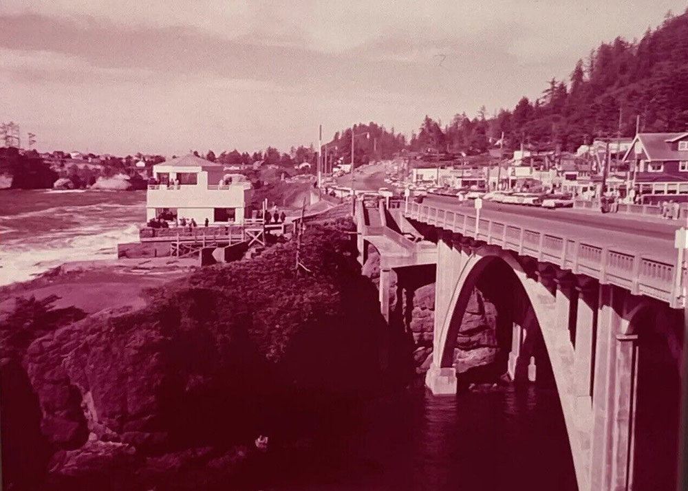
Depoe Bay in '50s. It's possible this old-timey shot is from the '60s too, though it's difficult to zoom in enough on the image to clearly see the cars.
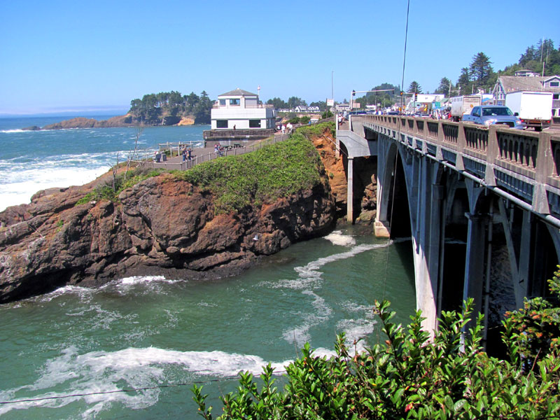
Depoe Bay is a late comer on the Oregon coast, only officially becoming a city in the '70s. Even so, little has changed from this vantage point, showing what would eventually become the Oregon Coast Aquarium store – and then later the Whale Watching Center. Hotels in Depoe Bay - Where to eat - Depoe Bay Maps and Virtual Tours
Cannon Beach Lodging
Nehalem Bay Lodgings
Manzanita Hotels, Lodging
Three Capes Lodging
Pacific City Hotels, Lodging
Lincoln City Lodging
Depoe Bay Lodging
Newport Lodging
Waldport Lodging
Yachats Lodging
Oregon Coast Vacation Rentals
Oregon Coast Lodging Specials
More About Oregon Coast hotels, lodging.....
More About Oregon Coast Restaurants, Dining.....
 Andre' GW Hagestedt is editor, owner and primary photographer / videographer of Oregon Coast Beach Connection, an online publication that sees over 1 million pageviews per month. He is also author of several books about the coast.
LATEST Related Oregon Coast Articles
Sea lion wandering near Newport / South Beach streets got some interesting looks. Marine sciences
Flooding Shuts Down Roads in Washington, Oregon, Coast
Road issues at Seaside, Neskowin, Hwy 6, SW Washington and more coming. Weather
S. Oregon Coast's Cape Blanco Celebrating 155 Years: A Look At That Lens
Historical look at the two lenses used since 1870. Port Orford events, history
McMinnville Oregon Weather - Forecasts, Sky Cams, Alerts, Current Conditions
Weather forecasts, live sky cams, alerts and current conditions for McMinnville, Oregon. Portland, Hillsboro, Tualatin
Video: Notorious Bump on Route to Oregon Coast Replicates - But There's a Hum...
Recent storms have caused more landslides that lead to roadway buckling. Traffic
Oregon Coast Town Looks at Possibility of Life Out There with Yachats Event
Jan 11 at the Yachats Commons examines the moon Europa. Yachats events
2026 Beachcombers 'n Glass Float Expo Brings Real Glass Floats to Washington ...
Feb 14 through March 8 they're dropped; Expo at Ocean Shores March 7?8. Washington events
State Parks Dept Wants Input on New Drone Rules for Inland Oregon, Coast
Public input: rules would affect where drones can take off, land. Safety
Back to Oregon Coast
Contact Advertise on Oregon Coast Beach Connection
All Content, unless otherwise attributed, copyright Oregon Coast Beach Connection. Unauthorized use or publication is not permitted


