Neahkahnie Viewpoint Provides Fun History, Unsolved Mystery on N. Oregon Coast
Published 01/21/21 at 4:46 AM PDT
By Oregon Coast Beach Connection staff
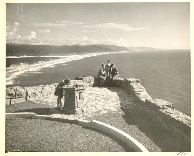
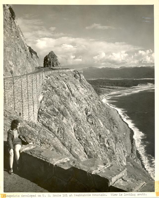
(Manzanita, Oregon) – Neahkahnie Viewpoint, above Manzanita on the north Oregon coast, has been a scenic stunner for over 80 years now. Often known as the Neahkahnie Overlooks, it’s really a series of them, and they’ve probably provided millions with eye-popping views through more than four generations. That stone wall going around each of them, with signage at the largest parking lot, have made for a lot of interesting atmosphere as well, creating almost an ancient castle vibe. (All historical photos courtesy ODOT)
The history of Neahkahnie Viewpoint and its overlooks is a fun one to take a look at in pictures, and the historical arm of Oregon Department of Transportation (ODOT) recently provided Oregon Coast Beach Connection with some interesting glimpses into the landmark's past. Then, however, on top of all the intricate history of the place, it turns out those stone walls have a little mystery built in – a puzzle of a feature that just can’t seem to be solved.
From the mid 1920s to 1932, the Oregon coast was slowly building all of Highway 101, originally known as the Roosevelt Military Highway (named after Teddy, not the later Franklin D.). From Brookings to Astoria, all of it was finished that year. Except at Manzanita: the stretch around Neahkahnie Mountain between Nehalem and the junction of U.S. 101 and U.S. 26 wasn’t there yet, and for a time it seemed like the highway was completed without it. The only way between Cannon Beach and Manzanita was winding, twisty and annoying Highway 53.
The road around Neahkahnie followed an old native trail, according to ODOT documents. Other historical photos of the spot before the road show those trails.
Whether or not the Arch Cape Tunnel was part of the entire package is unclear, but the go ahead to build that came in 1936. It wasn’t started until at least 1937 and opened up somewhere about 1940.
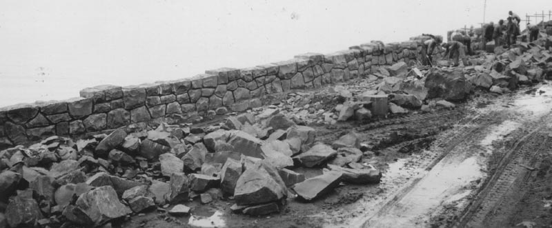
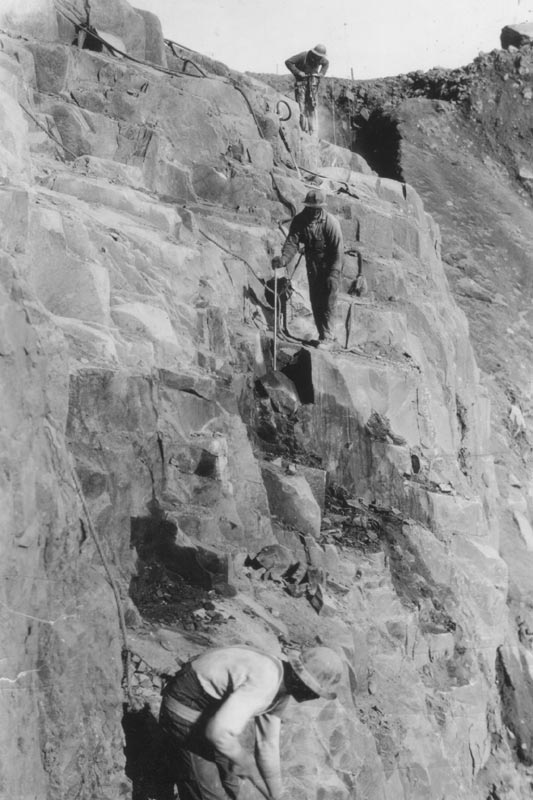
Above: work on the rock wall in 1940
What is known is that – according to ODOT librarian Laura Wilt – paving and major construction on the Neahkahnie Mt. area was started in early 1940 (photo at bottom of article). However, the viaducts and the chasm bridge started work in 1937, and photos clearly show a primitive road inching around what must’ve been a precarious bend.
“The contract for the section of the Coast Highway along Neahkahnie Mt. was awarded to K. L. Goulter Co. on 12/08/1939,” Wilt told Oregon Coast Beach Connection.
Indeed, newspaper coverage at the time shows some work in August of 1938, such as Coos Bay’s The World writing about grading work being done around Neahkahnie and the stretch from Arch Cape to Cannon Beach.
ODOT historical documents show the overlooks and the highway here were officially opened up in 1941. Newspaper coverage around Oregon gets a little all-over-the-place in the summer of 1941, with some saying it was partially opened up on August 16, then a full opening in September, and another paper writes it officially opened on August 3.
According to ODOT:
“The concrete curbing and the masonry stone wall that line this stretch of road were designed to be scenic as well as functional. Carved from the rock, the roadway accommodates the scenic splendor and natural features of the mountainside. Envisioned as both a scenic byway and an artery of commerce, the Oregon Coast Highway construction incorporates natural features and ample pullouts whereby motorists and cyclists can safely stop and take a moment to appreciate the natural beauty. This approach comes from the Bureau of Public Roads (now FHWA), who adopted these designs from the National Park Service.”
ODOT documentation says this was the largest highway rockwork done in the state, and “they reflect the spirit of an era.”
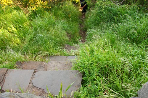
The mysterious stairway at Neahkahnie Overlooks
Yet those rock walls also present a bit of a mystery. At the main overlook parking lot, if you look close, there’s an odd little set of steps descending through the brush, but on the other side of the wall. There’s no gap there, so it takes a little climbing to get over and get down to the steps. The steps then lead to a footpath out onto a dangerous outcropping of Neahkahnie.
The fact the wall is closed there – and the pure dangers inherent in the spot – make it clearly evident state officials don’t want you going out there. So why are the steps still there? When was this walled off?
Finding the steps is truly finding something hidden. Yet when Oregon Coast Beach Connection asked around, no one knew what the story was. Oregon State Parks and Recreation knew nothing of the steps or their history. They deferred to ODOT, who technically run the overlooks at Neahkahnie. ODOT management sent Oregon Coast Beach Connection to its historical librarian, and Wilt knew nothing of it.
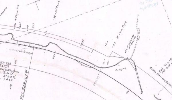
Wilt, however, did find it in the blueprints for the overlooks, dated 1940. You can see the footpath clearly taking off from the rock wall, but the document doesn’t necessarily show an opening or not. (The footpath is the dotted line)
It’s now like finding a hidden compartment in an old house. Cool.
“The contract plan for the project, 3V-095, shows that parking area on sheet 5, but doesn’t indicate that there would be a gap in the masonry wall,” Wilt said. “One item of note is that the parapet wall ended with that parking area. I wonder if there was originally a path around the outside end leading to the foot trail?”
The history of Neahkahnie Viewpoint may be clear, well mostly clear. But that footpath and any opening that might’ve been there remains a mystery. See more historical photos below:
Hotels in Manzanita, Wheeler - Where to eat - Manzanita, Wheeler Maps and Virtual Tours


Cannon Beach Lodging
Nehalem Bay Lodgings
Manzanita Hotels, Lodging
Three Capes Lodging
Pacific City Hotels, Lodging
Lincoln City Lodging
Depoe Bay Lodging
Newport Lodging
Waldport Lodging
Yachats Lodging
Oregon Coast Vacation Rentals
Oregon Coast Lodging Specials


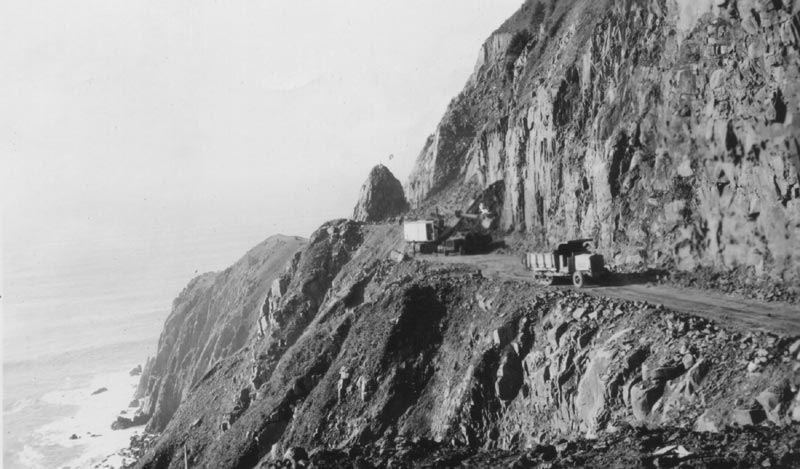
Under construction, dated February 1940
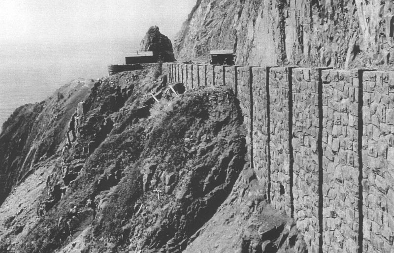
After the construction, circa 1941
Caption on photo: "Construction activities near Sta. 223. 4/10/40 – Neahkahnie Mt. Section, showing inclination of rock sloping towards future wall. This inclined plane is found beneath each layer."
More About Oregon Coast hotels, lodging.....
More About Oregon Coast Restaurants, Dining.....


LATEST Related Oregon Coast Articles
New and Freaky Critters at Oregon Coast Aquarium with Amazon Exhibit20 May 2026 at 11:34pm
Starting May 23 in Newport and going through January. Newport events
Oregon Coast Highway Near Neskowin Finally Reopens Both Lanes After Dec Lands...
Nearly six months of one lane are over. Traffic, Lincoln City, Pacific City
Coast Guard Calls Off Search Along Inner Washington Coast After Body Found
23 May 2026 at 11:27pm
65-year-old man missing near Point Wilson, Washington. Safety
Gnarly, Somewhat Gruesome Video of Killer Whale Attack on Oregon Coast
19 Jun 2026 at 9:06am
Unusual top-down footage of them hunting a harbor seal. Marine sciences, Seal Rock, Depoe Bay, Newport, Yachats
A big change for central Oregon coast's Lincoln City Summer Kite Festival
18 May 2026 at 9:54am
June 27 - 28: but with a hefty change: moved from the D River to Chinook Winds Resort. Lincoln City events
Absolute Complete Guide to Oregon Coast Fourth of July, 2026: All Towns
19 Jun 2026 at 9:06am
Astoria events, Seaside events, Cannon Beach events, Manzanita events, Rockaway Beach events, Tillamook events, Oceanside events, Pacific City events, Lincoln City events, Depoe Bay events, Newport events, Waldport events, Yachats events, Florence events, Reedsport events, North Bend events, Coos Bay events, Charleston events, Bandon events, Port Orford events, Gold Beach events, Brookings events. Weather
World's Largest Creature: Skeleton Assembled and Now Open at Oregon Coast's H...
22 May 2026 at 9:34pm
New landmark rising in Newport: the fully assembled skeleton of a 70-foot blue whale. Newport events
2026 Elections: Oregon's Measure 120 Goes Down Fast - At Least So Far
20 May 2026 at 12:34am
Controversial gas tax is out, says Associated Press. Traffic
Back to Oregon Coast
Contact Advertise on BeachConnection.net
All Content, unless otherwise attributed, copyright BeachConnection.net Unauthorized use or publication is not permitted

Oregon
Coast Hotels
S. Coast Hotels
Seaside Hotels
Cannon
Beach Hotels
Nehalem Bay Lodgings
Manzanita Hotels, Lodging
Rockaway Beach Hotels
Three Capes Lodging
Pacific City Hotels, Lodging
Lincoln
City Lodging
Depoe
Bay Hotels
Newport Hotels
Waldport Lodging
Yachats
Lodging
Oregon
Coast Vacation Rentals
Oregon
Coast Lodging Specials
South Coast Hotels
Dining
Guide
Seaside
Cannon
Beach Dining
Manzanita,
Rockaway, Wheeler Dining
Pacific
City, Oceanside, Netarts, Tierra Del Mar Restaurants
Tillamook
Bay Restaurants, Dining
Lincoln
City Dining, Restaurants
Depoe
Bay Restaurants, Dining
Newport Restaurants, Dining
Waldport,
Yachats Restaurants, Dining
Florence Restaurants, Dining
Restaurant
Reviews
Coast
Events Calendar
Astoria
Seaside,
Cannon Beach Calendar
Manzanita,
Rockaway Events
Tillamook,
Pacific City Calendar
Lincoln
City Events Calendar
Newport,
Depoe Bay Events Calendar
Yachats Events Calendar
Oregon Coast Complete Guides every beach access, attraction
Search for Oregon Coast Subjects, Articles
Explore Every Beach Spot


News Headlines from All Over Oregon Need to scan Oregon headlines? Constantly updated news from all over Oregon: a comprehensive, up-to-the-minute display of news headlines from a variety of media
Oregon Coast Oceanfront Lodging, Hotels, Rentals
Book Coastal Lodging Now
Booking.com